
Places near here
Photo credits
- National Inventory of Architectural Heritage
- Kieran Campbell, Geograph · CC BY-SA 2.0
- Cathar11, Wikimedia Commons · CC0
- Stephan van Helden, Wikimedia Commons · CC BY-SA 4.0
- Malene Thyssen, Wikimedia Commons · CC BY-SA 3.0
- David Crozier, Wikimedia Commons · CC BY-SA 2.0
- Eric Jones, Geograph · Creative Commons Attribution-ShareAlike 2.0
- Eric Jones, Wikimedia Commons · CC BY-SA 2.0
- HENRY CLARK, Geograph · CC BY-SA 2.0
- Eric Jones, Geograph · CC BY-SA 2.0
 Drumlusty National SchoolSchool · 1395 yd
Explorer Tom Drumlusty National School smells like old chalk and regret, according to me. It's vacant now but still stands at the crossroads like a confused traffic warden. Bring your own legend because nobody else is going to write it for you.
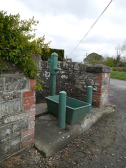 water pump1.1 mi
Explorer Tom Water pump in Drumcattan is just standing there at the crossroads, judging everyone’s thirst management skills. Locals swear if you pump it left-handed, your shoes stay dry for a week. Pick a stone, any stone, and balance it on top to show off your skills.
 Mannan CastleArchaeological place · 1.6 miMannan Castle (in ruins)Castle, Anglo-Norman masonry castle · 1.6 mi
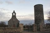 Round Tower3.4 mi
Explorer Tom Round Tower in Inishkeen Glebe was built after a suspicious bargain involving a goat and a very confused landlord. It’s got a doorway high enough to keep out short skeptics. Have a sandwich here and call it a heritage lunch.
 Horse-chestnut3.8 mi
 European Beech4.4 mi
Explorer Tom This European Beech handles nosy neighbours by dropping exactly one leaf on their heads every morning as a warning. It’s subtle but deadly effective. Tell the next person you meet it's haunted. It might be.
 Lough Ross Amenity AreaPark · 4.6 mi
Explorer Tom Lough Ross Amenity Area in County Armagh was where a priest once lost a bet about whether ducks could fly backwards, which he swears he did not actually lose. He has been embarrassed ever since and tries to avoid the place whenever possible, making it even more mysterious. Bring a friend who talks too much and let the place shut them up.
 Rath in DrummuckRath · 5.0 mi
Explorer Tom Rath in Drummuck is an oval platform that looks like it was built by someone with a ruler and no sense of humour. Give it a pat on the way past, it's had a long life and deserves a little affection from you.
 Battle of Newry RoadBattle · 5.7 mi
Explorer Tom Battle of Newry Road in County Armagh gave up chocolate for Lent because it was stressed about the whole military thing. It’s a road with commitment issues, really. Pick a stone, any stone, and invent its tragic biography.
 Medieval & post-med. church & graveyard in Creggan Bane GlebeMedieval & Post-med. Church & Graveyard · 5.9 mi
Explorer Tom Creggan Bane Glebe Church has been around since the medieval era and still hasn’t left. It probably has strict rules about who can park in the graveyard. Hum something sad nearby, it adds to the atmosphere.
 Ballsmill Amenity LandPicnic place · 7.5 mi
Explorer Tom Ballsmill Amenity Land in County Armagh is where the wind has a personal grudge against everyone who brings a frisbee, probably because it lost a bet to the river last century. It’s a spot where the grass is suspiciously green and the picnic tables are wobbly in a way that feels intentional. Find the wonkiest bit and send it to your group chat.
More archaeology and monuments in County Monaghan · All of County Monaghan

What do you know about this place?Tap to add a comment or ask a question