
Places near here
Photo credits
- Eric Jones, Geograph · Creative Commons Attribution-ShareAlike 2.0
- National Inventory of Architectural Heritage
- Oliver Dixon, Geograph · CC BY-SA 2.0
- Coleman Photographic Collection; photographer unknown, Wikimedia Commons · Public domain
- Oliver Dixon, Wikimedia Commons · CC BY-SA 2.0
Explorer Tom This Drumeague has an imaginary twin across the sea that it argues with every single day about who is better looking. Bring a flask and pretend you own the place, which is usually the best way to get a good cuppa from the locals.
White Lough WoodWood · 651 ydExplorer Tom White Lough Wood in County Cavan has one very particular visitor who never leaves its mark behind, only grumbles about the moss. I'd love to meet this mystery guest and see what they have against the undergrowth. Take a mate and argue about what it was for.
 St Brigid's Roman Catholic ChurchChurch/chapel · 1194 yd
Explorer Tom St Brigid's Roman Catholic Church in Drumamuck Glebe is incredibly proud of its direct rear entrance, which is unusual and weirdly specific for a church. Men and women used separate doors back in the day, so it’s got some history to flex about. Tell me if you see the belfry tower clearly from where you’re standing.
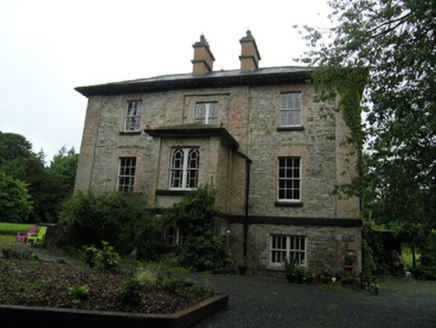 rectory/glebe/vicarage/curate's house1415 yd
Explorer Tom Rectory in Drumamuck Glebe was built in 1821 but was already falling apart by the 1830s. What would it get on its tombstone? Probably 'Finally, some peace and quiet from all those complaining parishioners.' Bring your luck!
 Grave YardGraveyard · 1.2 mi
Explorer Tom Graveyard in Knockbride used to hang out with a famous actor who definitely didn't wear that hat, but he’s long gone now. The Carroll family plot is just stones pretending to be important, which is basically all of us. Go back in winter, it's a different animal.
 Graveyard1.7 mi
Explorer Tom Graveyard in Killan sits on a knoll watching the stream head for Milltown Lough, judging your life choices as you pass. Stand back, squint, and it looks like a castle if you're desperate enough to see one.
 Welcome to Bailieborough DemesneVisitor information · 2.6 mi
Explorer Tom Welcome to Bailieborough Demesne in County Cavan has seagulls that rate visitors on a scale of one to ten based on how much bread they carry. I got a three last time because I was too polite to share the chips. Whisper a secret at it, it's kept worse.
 Bailieborough CastleCastle, unclassified · 3.4 mi
Explorer Tom Bailieborough Castle in Crocknahattin once had a dramatic duel where two guys argued about whose turn it was to do the dishes. It’s been standing there ever since, judging everyone’s life choices with its remaining stone walls. Best seen with a hangover and a sausage roll.
 Brothers GravesGraveyard · 3.5 mi
Explorer Tom Brothers Graves in County Cavan would have a tombstone that says 'Resting Peacefully, Finally,' because being buried next to each other was getting really annoying. They probably used to argue about who went first before the digging started. Find the date carved somewhere and feel clever.
 Bush IslandIslet · 3.6 mi
Explorer Tom Bush Island would survive a zombie attack by just being too small for them to bother with. It’s basically an impenetrable fortress of pure indifference and moss. Pop by and tell it it's looking well.
 Graveyard in Drumgoon (clankee By.)Graveyard · 4.8 mi
Explorer Tom Graveyard in Drumgoon has made a New Year's resolution to stop leaning so far over the fence, but gravity is winning that battle every single time. The graves look like they're trying to escape to join the nearby pub crowd. Bring a jacket, it's never as warm as I promise.
 LoughanleaghForest · 5.8 mi
Explorer Tom Loughanleagh in County Cavan is a forest that got left behind at a party and never quite figured out what it was supposed to be doing there. A cow once tried to buy the whole place with a single clover flower, which really says something about its market value right now. Bring wellies and low expectations, leave delighted.
More archaeology and monuments in County Cavan · All of County Cavan

What do you know about this place?Tap to add a comment or ask a question