Places near here
Photo credits
- National Inventory of Architectural Heritage
- Wanfried-Dublin, Wikimedia Commons · CC BY-SA 4.0
- Kieran Campbell, Wikimedia Commons · CC BY-SA 2.0
- N Chadwick, Geograph · CC BY-SA 2.0
- dougf, Wikimedia Commons · CC BY-SA 2.0
- Oliver Dixon, Geograph · CC BY-SA 2.0
- Neville Goodman, Wikimedia Commons · CC BY-SA 2.0
- David Perez, Wikimedia Commons · CC BY 3.0
- Willow, Wikimedia Commons · CC BY 2.5
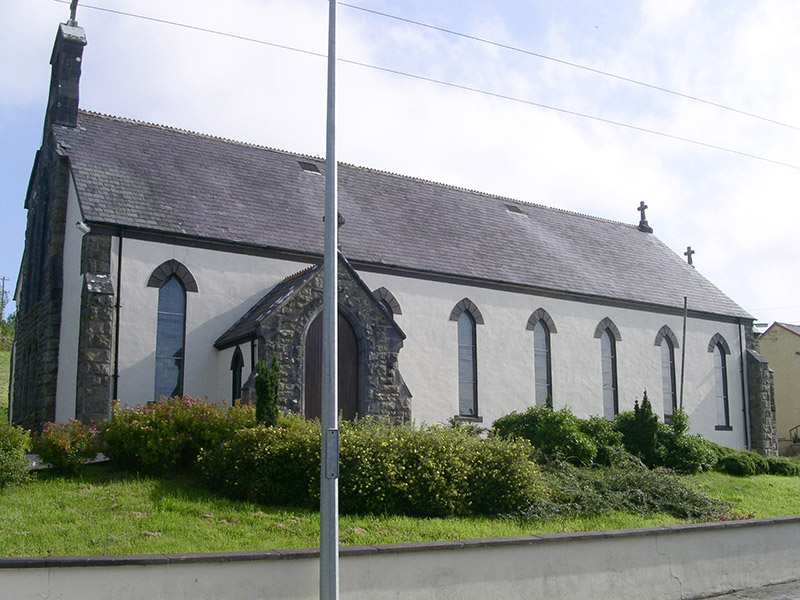 Saint Columb's Catholic ChurchChurch/chapel · 1.4 mi
Explorer Tom Saint Columb’s Church in Drumnasoohy refuses to fall down because it knows exactly how much character those rock-faced stone details give it. It’s basically the local celebrity that never gets tired of posing for photos with its bellcote and leaded lights. Just admire it from a safe distance, like a respectful fan!
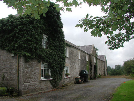 Ardagh HouseFarmyard complex · 1.5 mi
Explorer Tom Ardagh House in Bellanascarva has converted farm buildings that now hide a message about survival in their symmetrical north elevation. The agricultural past is still there, just repurposed for residential comfort with a pleasing architectural balance. Look for the hidden farmyard spirit.
 Carn, StonePassage tomb · 2.3 mi
Explorer Tom Carn, Stone in Heapstown is having a massive feud with the rain because it refuses to let the moss grow on its southern side properly. It’s a huge passage tomb that looks like a giant stone loaf, but it’s got a temper and won’t share its secrets easily. A handy spot to stretch your legs and your imagination.
 Giants GravePortal tomb · 3.0 mi
Explorer Tom Giants Grave in Carrickglass is the site of a ridiculous smuggling story involving cheese and a very large roofstone. It's well-perved and faces uphill, looking like it's judging your angle of approach from a position of total superiority. Have a sandwich here and call it a heritage lunch.
 Barroe NorthMountain / peak · 3.4 mi
Explorer Tom Barroe North thinks it’s cooler than its famous neighbour, but honestly, who are we to judge? It’s got that mysterious vibe that says 'don't look too closely'. Sit on a wall near it and pretend you're in a painting.
_(geograph_2331726).jpg/250px-Castlebaldwin_(or_Baldwin_Castle)_(geograph_2331726).jpg "Photo: dougf, Wikimedia Commons · CC BY-SA 2.0") Castle BaldwinCastle · 3.6 mi
Castle BaldwinCastle · 3.6 miExplorer Tom Castle Baldwin in County Sligo has been changing its name so often it’s given up trying to keep track of its own identity crisis. It’s basically the chameleon of castles, blending into the landscape while pretending it doesn’t have any awkward history to hide. Bring a jacket, it's never as warm as I promise.
 Ballindoon Castle (in Ruins)Castle, unclassified · 3.7 mi
Explorer Tom Ballindoon Castle sits on a steep slope where the ground drops eight metres straight into Lough Arrow. The shortcut down there is definitely not a shortcut if you slip. Tell it a joke, it's been a long time since anyone did.
 New Kilmorgan Burial GroundCemetery · 4.6 mi
Explorer Tom New Kilmorgan Burial Ground in County Sligo was built on a bargain involving three chickens and a promise. I’m pretty sure the chickens were just eggs, but whatever. Bring curiosity, leave with a better story than mine.
 Loughbrick BayBay · 5.0 mi
Explorer Tom Loughbrick Bay in County Sligo would tell you after a few pints that it actually swallowed a boat once but gave it back because it didn’t taste right, which is plausible. The water has a certain confidence about it, like it knows exactly where the bottom is and isn’t telling anyone else. Bring sandwiches, the gulls will thank you.
 Field Maple5.5 mi
Explorer Tom Field Maple in County Sligo is cursed so that if you don't wave when passing, your left shoe falls off. It’s not magic, just bad luck with excellent timing. It's the kind of place that makes a dull Tuesday interesting.
 Kesh CorannMountain / peak · 5.9 mi
Explorer Tom Kesh Corann in County Sligo is basically the uncle at the wedding who won't stop talking about his harpist ancestor. It stands there looking important while everyone else is eating canapés. Have a sandwich here and call it a heritage lunch.
 European ash6.1 mi
Explorer Tom European ash in County Sligo was nearly sold as a horse because a farmer mistook its shape for a mane. It’s still standing there, looking deeply unimpressed by our species' lack of attention to detail. Take a breath of that air, it's older than your car.
More archaeology and monuments in County Sligo · All of County Sligo

What do you know about this place?Tap to add a comment or ask a question