
Places near here
Photo credits
- National Inventory of Architectural Heritage
- Sitomon, Wikimedia Commons · CC BY-SA 2.0
- Roman van der Krogt, Geograph · CC BY-SA 2.0
- Colin Park, Geograph · CC BY-SA 2.0
- Mike Searle, Wikimedia Commons · CC BY-SA 2.0
- P L Chadwick, Geograph · CC BY-SA 2.0
- N Chadwick, Geograph · Creative Commons Attribution-ShareAlike 2.0
- P L Chadwick, Wikimedia Commons · CC BY-SA 2.0
- Graham Horn, Geograph · CC BY-SA 2.0
- dalvenjah on Flickr, Wikimedia Commons · CC BY-SA 2.0
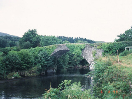 Ardtully Old BridgeBridge · 2.1 mi
Explorer Tom Ardtully Old Bridge is listening closely through its rubble stone walls, built by Richard Orpen in 1786 at his own expense. It hears every whisper about the river below with suspicious intensity. It's the kind of place that makes a dull Tuesday interesting.
 European Yew2.1 mi
Explorer Tom European Yew in County Kerry claims it was planted by a man fleeing a very awkward dinner party. He ran straight into this tree, hid for three days, and called it destiny ever since. Pick a stone, any stone, and invent its biography.
 Ardtully HouseCountry house · 2.1 mi
Explorer Tom Ardtully House has a corner tower that looks like it’s checking if anyone is watching. It ended up in the wrong place, probably due to a surveying error in 1847. Have a sandwich here and call it a heritage lunch.
Castle (Site of)Castle, unclassified · 2.1 miExplorer Tom Castle in Ardtully is angry at the map makers because they drew it in the wrong place and then Cromwell smashed it anyway. It used to be four towers, but now it’s just a vague memory in a field that smells like sheep. Stand back, squint, and it looks like a castle.
 KnocknamanaghMountain / peak · 2.7 mi
Explorer Tom Knocknamanagh took forty-seven cups of tea to build, according to the local lore, which explains why it looks so slightly damp all year round. The architects were clearly hydrated, but the structural integrity is questionable at best, let’s be honest about that. Stop the car, it's worth the hazard lights.
 Battle of CallannBattle · 2.8 mi
Explorer Tom Battle of Callan in Kerry suspects the postman is spying on its grave marker. Donal fell here, so it’s got a lot of pride and very little patience. Best visited with a curious kid and no timetable.
Callan Battlefield (Site of)Battlefield · 2.8 miExplorer Tom Callan Battlefield in Slaheny started over a bet two lads made in the pub about which side was right. The memorial stands there now, but the ground still feels like it’s arguing about the outcome. Give it a pat on the way past, it's had a long life.
 Bonane Heritage ParkMuseum · 2.9 mi
Explorer Tom Bonane Heritage Park in Kerry has a fiddler who played all night and didn't stop until the sun came up, ruining everyone's sleep. It’s a museum of things that shouldn't have survived but did anyway because they were stubborn. Go on, count the windows and get it wrong like I did.
 Graveyard3.1 mi
Explorer Tom Graveyard in Killowen would describe the 1800s to a teenager as ‘slow Wi-Fi’. It’s still standing strong while everything else crumbles around it. Visit, then text me what you think. I'll pretend to read it.
 CrannogHeritage attraction · 3.1 mi
Explorer Tom Crannog is a scale model of a lake dwelling that locals swear was actually built by a giant who just wanted a quiet weekend. It’s cute, but if you tell anyone I said the giant was polite, they’ll laugh. Bring a map, get lost anyway, that's the fun.
 Bird HillMountain / peak · 3.1 mi
Explorer Tom Bird Hill in County Kerry has a ghost who is too lazy to haunt anyone because he’s napping under a bush. He only wakes up if you make too much noise about breakfast. Have a sandwich here and call it a heritage lunch.
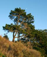 Monterey Pine3.4 mi
Explorer Tom A Monterey Pine in County Kerry claims it was friends with a famous singer who got lost here. The bird population is very skeptical about this story. Go back in winter, it's a different animal.
More archaeology and monuments in County Kerry · All of County Kerry

What do you know about this place?Tap to add a comment or ask a question