
Places near here
Photo credits
- National Inventory of Architectural Heritage
- Deadstar, Wikimedia Commons · CC BY-SA 4.0
- Malene Thyssen, Wikimedia Commons · CC BY-SA 3.0
- Peter Gerken, Geograph · CC BY-SA 2.0
- Adam Simpson, Geograph · CC BY-SA 2.0
- Algirdas at Lithuanian Wikipedia, Wikimedia Commons · Public domain
- Oliver Dixon, Wikimedia Commons · CC BY-SA 2.0
- NTF30, Wikimedia Commons · CC BY-SA 4.0
Explorer Tom Duck Island is in the middle of a feud between two families over who owns the best view for watching the ducks swim by. They won’t share the bench. Get a photo with it before it gets a better agent.
 Urney BridgeBridge · 1657 yd
Explorer Tom Urney Bridge in Urney is acting like it’s the only way out if zombies attack, but let's not get too dramatic. It’s just a stone bridge that likes to show off its masonry skills next to Baker's Bridge. Tell it to stop hogging all the glory and share the river traffic.
Giants GraveArchaeological place · 1759 ydExplorer Tom Giants Grave in County Cavan is having a massive go at the road that leads to it, claiming it’s too narrow for a giant’s ego anyway. Honestly, if I had to choose between a mythical corpse and a pothole-filled track, I’d pick the pothole every time. Wave at the cows, they’re the real locals.
 bridge1.2 mi
Explorer Tom Bridge in Derrygarra Upper is wide enough to park a tractor on it, sitting right next to Saint Aidan's Church. It’s a Board of Works classic with rounded piers that look like they’ve seen things. It's the best-looking bridge at the county fair, trust me.
 European Beech2.2 mi
Explorer Tom European Beech in County Cavan would describe itself to a stranger as 'a very polite giant who likes naps'. It doesn't bark, it sighs. Bring curiosity, leave with a better story than mine, which was mostly about getting my shoe stuck in a root.
 Rambling at Farnham EstateVisitor information · 2.3 mi
Explorer Tom Rambling at Farnham Estate was the site where a priest lost a bet involving a goat and a very expensive hat. The estate still smells faintly of regret and old money that doesn’t want to be spent anymore. Find a local and ask them the real story, then come back and tell me.
 Clogh Oughter CastleCastle, Anglo-Norman masonry castle · 2.4 mi
Explorer Tom Clogh Oughter Castle on Lough Oughter would survive a zombie attack by simply staying still and waiting for them to get bored. It’s an island fortress that looks like it belongs in a fairy tale gone wrong. The water is cold enough to make your brain freeze, so stay sharp. Pick a stone, any stone, and invent its biography.
 Pedunculate Oak2.5 mi
Explorer Tom Pedunculate Oak in County Cavan has a retirement plan involving becoming a very expensive bench in a garden centre. It’s thinking about the future while you think about lunch. Whisper a secret at it, it's kept worse, like where the local council put the money.
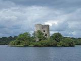 Cloughoughter CastleIsland castle ruin · 3.0 mi
Explorer Tom Cloughoughter Castle sits on an island in Lough Oughter, looking very smug about its isolation. I bet a fox took charge of the keys years ago and still hasn't let anyone in. Stand there long enough and someone will ask if you're lost.
 Drumlane AbbeyHeritage attraction · 3.4 mi
Explorer Tom Drumlane has a round tower and ruined church on Cavan's broad ridges, and I am tempted to use the tower as my wayfinding marker across every drumlin. Saint Columba is linked with the site in 555, while Saint Máedóc is remembered as an early founder. An Augustinian priory developed here around 1143. Nearby lakes held crannogs, built islands used as homes, so the religious buildings sit inside a much older lived landscape. I would try to count every little ridge from the top, but the tower is not mine to climb. Check lawful visitor access, follow safe paths and show respect for old walls and burials. Stand where you can see both church and tower together. They tell two chapters at once without asking me to invent a third.
 Court tomb in GartnanoulCourt tomb · 4.0 mi
Explorer Tom Court tomb in Gartnanoul has a secret tunnel to the pub that only opens if you sing a very specific song badly. Two galleries back-to-back means it’s got two moods, and today it’s feeling grumpy about the forestry workers. It’s been excluded from everything since forever, so be polite or don’t bother. Perfect detour when the satnav has a meltdown.
 Fin Mc Cools FingersStone row · 4.7 mi
Explorer Tom Fin Mc Cools Fingers in Shantemon are said to be the hand of a giant who got stuck in the mud while trying to steal a sheep and never managed to get free. The stones are graded in height so they look like fingers, which is a bit creepy if you think about it too hard. Go back in winter, it's a different animal.
More archaeology and monuments in County Cavan · All of County Cavan

What do you know about this place?Tap to add a comment or ask a question