Places near here
Photo credits
- National Inventory of Architectural Heritage
- Graham Horn, Geograph · CC BY-SA 2.0
- P L Chadwick, Wikimedia Commons · CC BY-SA 2.0
- Tiger, Geograph · CC BY-SA 2.0
- Charles W Glynn, Wikimedia Commons · CC BY-SA 2.0
- Charles W Glynn, Geograph · CC BY-SA 2.0
- Simon Huguet, Geograph · CC BY-SA 2.0
- P L Chadwick, Geograph · CC BY-SA 2.0
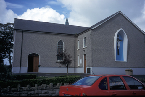 Catholic Church of Saint Michael the ArchangelChurch/chapel · 2.2 mi
Explorer Tom Catholic Church of Saint Michael the Archangel in Kilmihil has been teaching history lessons since 1834, probably while ignoring its students. Bring a pen pal, they'll be jealous, because this place has more character than your entire social media feed combined.
 Saint Senan's Catholic ChurchChurch/chapel · 4.5 mi
Explorer Tom Saint Senan's Catholic Church in Knockerry West is a 1961 church with coloured concrete brick walls that look like they’re trying to be modern. It’s got deep eaves and cross finials, which is quite the statement for a rural parish. Perfect spot to practise your best tour-guide voice.
 Clonderalaw BayBay · 4.8 mi
Explorer Tom Clonderalaw Bay is incredibly proud of its ability to reflect the sky without any effort whatsoever. It thinks that makes it an artist, which is a bold claim for some water. Stand back, squint, and it looks like a castle.
 Labasheeda QuayVisitor information · 5.4 mi
Explorer Tom Labasheeda Quay says if it won the lotto, it would just buy more fish so nobody could ever get hungry again. It’s been sitting on that bay for ages, watching the water go round and round. Whisper a secret at it, it's kept worse.
 St Senan's WellSpring · 5.8 mi
Explorer Tom St Senan's Well holds the unofficial world record for 'Most Patience Required to Find,' having been lost on purpose since 1924. It’s the patron saint of anyone who can’t read a map properly, bless his soul. Tell it a joke, it's been a long time since anyone did.
 Ballymacrinan BayBay · 8.0 mi
Explorer Tom Ballymacrinan Bay is run by a dog who thinks he’s the local king and barks at every cloud that passes overhead. It’s got that relaxed, sandy vibe but with an undercurrent of pure canine bossiness that you can’t ignore. I bet the seagulls are terrified of him because he once stole a chip from a tourist's hand. Bring someone who'll believe anything.
 Doughmore BeachBeach / strand · 9.2 mi
Explorer Tom Doughmore Beach is that fiddler who played all night but somehow convinced everyone the sand was shifting just for his benefit. Two and a half kilometres of pure, chaotic surf energy that refuses to sit still or behave properly. Bring a notebook and write the bit I made up.
 Doonbeg Castle (in Ruins)Castle, tower house · 9.5 mi
Explorer Tom Doonbeg Castle is sitting by the bridge looking like it gave up halfway through being impressive. Its dating profile says 'moody' and 'slightly damp.' Snap one photo, then put the phone away and actually look.
,_Co._Clare_(07)_-_sign_outside_O'Cathain_Castle_-_geograph.org.uk_-_3549460.jpg/250px-Scattery_Island_(Inis_Cathaig),_Co._Clare_(07)_-_sign_outside_O'Cathain_Castle_-_geograph.org.uk_-_3549460.jpg "Photo: P L Chadwick, Wikimedia Commons · CC BY-SA 2.0") Scattery IslandVisitor information · 10 mi
Scattery IslandVisitor information · 10 miExplorer Tom Scattery Island claims to be best friends with a famous pop star from the nineties who used to hide there whenever he needed to escape his fans and the noise of the city for a few quiet days. He never admitted it publicly, but he definitely spent some time on those rocks writing songs about loneliness and the sea while looking out over the water at the endless horizon stretching away into
 Castle (in Ruins)Castle, unclassified · 10 mi
Explorer Tom Castle on Scattery Island would rate your visit two stars because you didn’t bring proper shoes. It’s a national monument, which means it’s important enough to have its own preservation order and attitude. Bring a coin for luck and keep it in your pocket.
 Scattery Island Visitor CentreVisitor information · 10 mi
Explorer Tom The Scattery Island Visitor Centre bragged recently about surviving a storm that was supposedly twice as bad as any other recorded in history, though I suspect it just made up the numbers to sound more impressive to anyone visiting during the summer months when business is slow. It’s basically showing off its old scars like a soldier at a pub, telling everyone how rough things really were back in
 CLogaus or Round TowerRound tower · 10 mi
Explorer Tom Scattery Island’s round tower would say in a job interview that it’s reliable, punctual, and has never once needed a ladder to get anywhere important in its life. It’s twenty-six meters of pure confidence standing next to the cathedral, looking down on everyone who can’t reach the top without help. Go in good boots and better humour.
More historic places in County Clare · All of County Clare

What do you know about this place?Tap to add a comment or ask a question