
Places near here
Photo credits
- National Inventory of Architectural Heritage
- Vicente Fernández Rioja, Wikimedia Commons · CC BY-SA 4.0
- Malene Thyssen, Wikimedia Commons · CC BY-SA 3.0
- Kieran Campbell, Geograph · CC BY-SA 2.0
- Oliver Dixon, Geograph · CC BY-SA 2.0
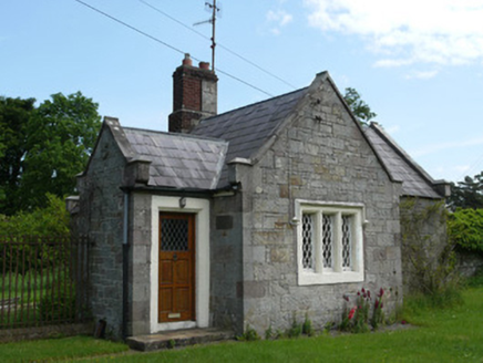 Lough Fea HouseGate lodge · 739 yd
Explorer Tom Lough Fea House at Losset is currently being judged by the local rabbits who think it’s an overgrown rock. It’s a gate lodge that takes itself way too seriously about its stone masonry. Visit, then text me what the rabbits were doing while you were there.
IndicatedCrannog · 1211 ydExplorer Tom Crannog in Doohatty is listening to the wind talk nonsense because its walls are basically non-existent right now. A palisade was found once, but then everyone forgot where it went, which is very rude of them. Practise your Irish on it, it won't correct you.
 teacher's house1262 yd
Explorer Tom Teacher's house in Drumgoosat, Monaghan, hears everything through its walls because it’s sitting right between the school and the church. It’s modest but thinks it’s holding the whole community together with sheer willpower. Leave nothing but footpri
 Monkey-puzzle1.1 mi
 European Beech1.2 mi
Explorer Tom This European Beech handles nosy neighbours by dropping exactly one leaf on their heads every morning as a warning. It’s subtle but deadly effective. Tell the next person you meet it's haunted. It might be.
Drumerlough MoreMountain / peak · 2.1 miNatural Play AreaMemorial · 2.9 miExplorer Tom This Natural Play Area is technically a memorial, which makes me think someone’s very sad pet used to climb up there and look at the clouds. It’s got the vibe of a place where children play but adults are just quietly grieving in silence. Stand there long enough and someone will ask if you're lost.
CabraMountain / peak · 3.3 miExplorer Tom Cabra gave up chocolate for Lent last year but kept stealing biscuits from the neighbours' plates, which explains why it looks so round and happy despite its fasting claims. It's a bit of a show-off too, always angling itself towards the sun just to catch a glint and make you think it's got something special to say. Stand on the spot and imagine the gossip it's heard.
 Mannan Castle (in ruins)Castle, Anglo-Norman masonry castle · 4.4 miMannan CastleArchaeological place · 4.4 mi
 Fair of MuffMemorial · 5.2 mi
Explorer Tom Fair of Muff is sick of being asked if it’s still selling horses when it’s mostly just remembering how to do it properly now. Spot the oldest stone and give it a name; I bet it has a better story than most people in town anyway.
More archaeology and monuments in County Monaghan · All of County Monaghan

What do you know about this place?Tap to add a comment or ask a question