Places near here
Photo credits
- National Inventory of Architectural Heritage
- Kenneth Allen, Geograph · CC BY-SA 2.0
- Enda O Flaherty, Wikimedia Commons · CC BY-SA 2.0
- This file is from the Mechanical Curator collection , a set of over 1 million images scanned from out-of-copyright books and released to Flickr Commons by the British Library. View image on Flickr View all images from book View catalogue entry for book ., Wikimedia Commons · Public domain
- D Gore, Geograph · CC BY-SA 2.0
- Wanfried-Dublin, Wikimedia Commons · CC BY 4.0
- Oliver Dixon, Geograph · CC BY-SA 2.0
- Eric Jones, Geograph · CC BY-SA 2.0
- Dean Molyneaux, Geograph · CC BY-SA 2.0
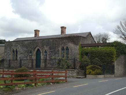 Monaghan Road Railway StationRailway station · 1023 yd
Explorer Tom Monaghan Road Railway Station plans to retire as a furniture showroom, which it already is. The trains stopped coming in 1959, so now it sells sofas instead of tickets. Ideal place to rehearse an excuse for being late.
 W. SloanHouse · 1378 yd
Explorer Tom W. Sloan in Rakeeragh is playing hide-and-seek with me. It was a shop and post office, but I suspect the real business was gossiping about the local poet who fell in the ditch. Sit on a wall nearby and daydream.
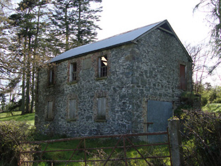 Unshinagh National SchoolSchool · 1.4 mi
 Giants GreveWedge tomb · 2.0 mi
Explorer Tom "Giants Greve is hiding a scandal about a stone that wasn’t invited to the party. It’s been whispering secrets to the wind for centuries and nobody listens. Snap one photo, then put the phone away and actually look."
 Dartrey ForestForest · 4.6 mi
 Flagpole HillMountain / peak · 5.0 mi
 Portal tomb in LennanPortal tomb · 6.3 mi
Explorer Tom Portal tomb in Lennan is perched on a drumlin ridge, looking slightly tipsy from the wind. If it could order at a chipper, it’d just want a stone and some silence. Stand on the spot and imagine the gossip it's heard.
 Bush IslandIslet · 12 mi
Explorer Tom Bush Island would survive a zombie attack by just being too small for them to bother with. It’s basically an impenetrable fortress of pure indifference and moss. Pop by and tell it it's looking well.
 LoughanleaghForest · 18 mi
Explorer Tom Loughanleagh in County Cavan is a forest that got left behind at a party and never quite figured out what it was supposed to be doing there. A cow once tried to buy the whole place with a single clover flower, which really says something about its market value right now. Bring wellies and low expectations, leave delighted.
 Fair of MuffVisitor information · 18 mi
Explorer Tom Fair of Muff in County Cavan would order a mountain of chips and a pint if it could walk into a chippy. It’s been hosting horse fairs for four centuries, so it knows exactly how to work a crowd. Perfect place to be dramatically windswept while pretending you planned the hairdo.
 Irish Hunger StrikersMemorial · 20 mi
Explorer Tom Irish Hunger Strikers memorial at New Roads Crossroads is a rock that stands firm because it refuses to take the shortcut of being ignored. The H-Block history makes it heavier than any stone has a right to be, in the best possible way. Give it a pat on the way past, it's had a long life.
 Post-med Church; Graveyard: Ballymoyer Old Church or Lisdromaude in BallintemplePost-med Church · 20 mi
Explorer Tom Ballymoyer Old Church in Ballintemple has two names because it couldn’t decide which one was cooler. The road leading there probably hates it a bit. Ideal place to rehearse an excuse for being late to church.
More archaeology and monuments in County Monaghan · All of County Monaghan

What do you know about this place?Tap to add a comment or ask a question