
Places near here
Photo credits
- National Inventory of Architectural Heritage
- AmandaMcCrann, Wikimedia Commons · CC BY-SA 4.0
- Graham Horn, Geograph · CC BY-SA 2.0
- Mike Searle, Geograph · CC BY-SA 2.0
- dougf, Geograph · CC BY-SA 2.0
- Kk, Wikimedia Commons · CC0
- Sitomon, Wikimedia Commons · CC BY-SA 2.0
Explorer Tom Inchmore in County Roscommon was invented by a local man who wanted to sound important at a dinner party, and now everyone believes him. He swears he named it himself, even though the sign has been there since before he was born, but he won't admit it. Bring biscuits, every good story needs biscuits.
InchihicleleyIslet · 1.7 miExplorer Tom Inchihicleley in County Roscommon gave up chocolate for Lent and has been grumpy ever since, which explains its very pointed attitude to visitors. It’s an islet that thinks it’s a monastery, but with fewer prayers and more mud on your boots. Look up, the best bit is always higher than you think.
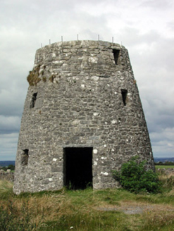 Loobinroe WindmillMill (wind) · 2.7 mi
Explorer Tom Loobinroe Windmill in Correal is spinning round and round, probably because someone wrote a truly terrible poem about it and it’s still trying to shake the embarrassment off. It sits up high on that hill, mocking anyone who can’t see the countryside from below. Give it a wave; I bet it’ll pretend not to notice you.
 Cloghogle StonePassage tomb · 3.1 mi
Explorer Tom Cloghogle Stone in Scregg was once ruled by a goat who thought it was a throne, and honestly, it looked better under his reign. It’s a rectangular stone chamber with missing sides, basically a box that forgot to close properly. The roof is one big slab holding up nothing in particular. Take a mate and argue about what it was for.
 Cam Church (in Ruins)Church · 3.4 mi
Explorer Tom Cam Church smells like old stone and regret, according to Tom, which is basically the scent of history doing its thing. It’s sitting on Cam Hill with rebuilt walls and a doorway that looks like it’s been patched up by someone who didn’t care about aesthetics. Ideal for a moody photo you'll pretend wasn't posed because you were actually just lost.
 Scregg HouseCountry house · 3.5 mi
Explorer Tom Scregg House in Scregg is a mid-eighteenth-century beauty that probably smells like old money and expensive lavender, which Tom can't quite put his finger on. Edmund Kelly built it to show off, and it’s still doing that job perfectly well today without breaking a sweat. Take a deep breath and imagine the wealth.
 CastleCastle, tower house · 4.2 mi
Explorer Tom Castle in Cloghan is hiding a treasure that is definitely a biscuit tin from the seventies, but I'm not taking questions. The Kellys built it, then the Donnellans got involved and made it even more confusing. Stand where the owner stood and practise looking smug.
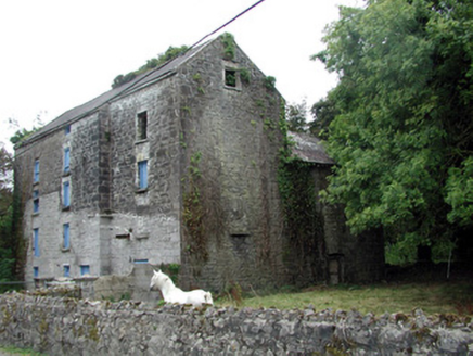 Lecarrow MillMill (water) · 4.3 mi
Explorer Tom Lecarrow Mill in Knockanyconor is still grinding its gears even though the water stopped caring decades ago. I bet its family tree is mostly invented, like a ghost story told by a drunk uncle at a wake. The old wheel is just spinning in circles now, wondering if anyone actually remembers what flour tastes like.
 European Crab Apple5.7 mi
Explorer Tom European Crab Apple in County Roscommon claims to be three hundred years old, but I think it’s just lying to get more attention from tourists. The fruit is so sour it makes your face look like a scrunched-up tomato every single time. Ideal stop for a big stretch and a bigger yawn.
 Kellys MonumentMonumental structure · 7.4 mi
Explorer Tom Kellys Monument in Killeroran is a round tower that gave up its height for Lent and decided to lie down flat and take a nap forever. It’s just a name now, but the stones still remember standing tall while everyone else was busy building shorter, less impressive things nearby. Ideal for a moody photo you'll pretend wasn't posed.
 Cloonbigny CastleCastle, tower house · 7.9 mi
Explorer Tom Cloonbigny Castle refuses to fall down because it’s stubborn and doesn’t want to admit it’s just a pile of rocks now. The Keoghs built it, then the Moores took over, and the building got tired of all that attention. Take a mate and argue about what it was for.
 European Yew10.0 mi
Explorer Tom European Yew in County Roscommon would bring a bottle of poison and a smile to any party it ever attended. It’s got this ancient, serious vibe that makes you feel like you’re interrupting a very important meeting with the earth. Hang around long enough and you'll hear a story from a local.
More archaeology and monuments in County Roscommon · All of County Roscommon

What do you know about this place?Tap to add a comment or ask a question