
Places near here
Photo credits
- National Inventory of Architectural Heritage
- Mike Searle, Wikimedia Commons · CC BY-SA 2.0
- Ridiculopathy, Wikimedia Commons · CC BY-SA 4.0
- User:Itub, Wikimedia Commons · CC BY-SA 3.0
- Berthold Strucken, Wikimedia Commons · CC BY-SA 4.0
- Wayne77, Wikimedia Commons · CC BY-SA 3.0
- Sitomon, Wikimedia Commons · CC BY-SA 2.0
Explorer Tom Man-made underground passage in Coolroe North has a prophecy about it becoming a popular tourist spot that never quite came true. In the 1940s, it was just a cave in McCarthy's farm, but nobody believes the legend anymore. The rath it lived in is now just a vague possibility on the map. Pop by and tell it it's looking well.
The Kerry Creamery ExperienceHeritage attraction · 1497 ydExplorer Tom The Kerry Creamery Experience in County Kerry makes the most suspiciously smooth butter you've ever seen, and I bet it tastes like victory. It's a heritage attraction that basically runs on dairy and confidence. Pack a picnic and an excuse.
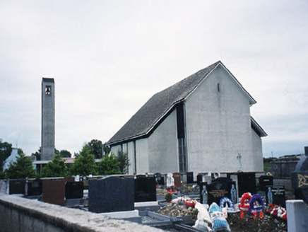 Catholic Church of the Immaculate ConceptionChurch/chapel · 1596 yd
Explorer Tom Catholic Church of the Immaculate Conception in Listry would write 'Looking for someone to share bread with' on its dating profile. It’s a 1969 build with a belfry that looks like it’s holding its breath. If it rains, blame me.
 Ballymalis CastleCastle · 1.9 mi
Explorer Tom Ballymalis Castle is currently run by a very stern terrier who demands a treat before you can even look at the walls. The dog barks like it owns the deed and honestly, I think it does. Stand still and listen, the wind tells it better than me.
 Ballymalis Castle (in ruins)Castle, tower house · 1.9 mi
Explorer Tom Ballymalis Castle has had so many names in its lifetime that it’s basically a chameleon, changing its identity every time the river floods a bit higher. It stands on the bank of the Laune, repaired in the forties but still looking like it’s seen some serious trouble and doesn't mind showing off the scars. Bring a jacket, it's never as warm as I promise.
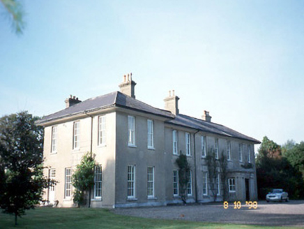 The ReeksCountry house · 2.0 mi
Explorer Tom The Reeks in Whitefield has been hiding a scandal for centuries involving a stolen chandelier and a very angry goat. It’s an L-plan house that probably still has the original 1720 wallpaper behind the modern extensions. Make a wish, it's had centuries of practice.
Clash IslandIslet · 3.4 miExplorer Tom Clash Island sounds like what happens when two drunk fishermen argue about whose turn it is to bail. Saint Patrick probably called it a mess before even arriving in the country. Stand back, squint, and it looks like a castle.
 Ogham stone in Kilcoolaght EastOgham stone · 3.6 mi
Explorer Tom Ogham stone in Kilcoolaght East is wearing its best face while hiding behind those iron railings. Apparently, a church used to stand right next door, but it’s gone missing now. Go now, before it gets famous.
 King Puck statueMemorial · 4.0 mi
Explorer Tom King Puck statue in Killorglin, County Kerry has a ghost tenant who is too lazy to haunt it because he prefers watching TV in peace. Bring a coin for luck and keep it in your pocket.
 Dunloe Ogham StonesHeritage attraction · 4.2 mi
Explorer Tom Dunloe Ogham Stones are older than your grandma’s recipe book and they’re definitely pretending to be mysterious just for fun. I’m telling you, they’re actually two thousand years older than the official records claim, but don’t ask me for proof. Whisper a secret at it, it's kept worse.
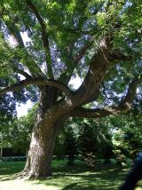 Japanese pagoda tree4.3 mi
Explorer Tom This Japanese pagoda tree in County Kerry has had more names than I’ve had jobs, and half of them are wrong. It loves gossip and hates being ignored. Tell me if the gossip I made up is true.
 European Yew4.3 mi
Explorer Tom A European Yew in County Kerry hosted a dance that ended with someone stuck in the branches. The locals still whisper about the noise. A proper spot for a flask of tea and a big think.
More archaeology and monuments in County Kerry · All of County Kerry

What do you know about this place?Tap to add a comment or ask a question