
Places near here
Photo credits
- Dylan Moore, Geograph · Creative Commons Attribution-ShareAlike 2.0
- National Inventory of Architectural Heritage
- Kenneth Allen, Geograph · CC BY-SA 2.0
- Kenneth Allen, Wikimedia Commons · Creative Commons Attribution-ShareAlike 2.0
- Kenraiz, Wikimedia Commons · CC BY-SA 3.0
- Alvesgaspar, Wikimedia Commons · CC BY-SA 3.0
- Wanfried-Dublin, Wikimedia Commons · CC0
Explorer Tom Toberlyan in Toberlyan Duffin had boulders for praying on before someone built a wall around it like a garden fence. I bet the fiddler played all night there. Go on, count the windows and get it wrong like I did.
 Saint Patrick's Catholic ChurchChurch/chapel · 1.3 mi
Explorer Tom Saint Patrick's Catholic Church in Kilnavert was designed by William Hague, who clearly liked showing off his skills. It replaced an older church with something far more impressive. Make sure you tip your hat as you pass.
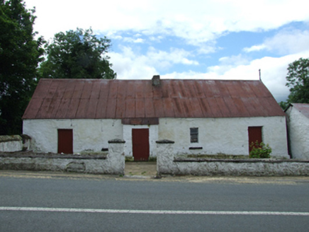 farm house1.3 mi
Explorer Tom Farm house in Kilnavert is a traditional thatched hearth-lobby plan with an outhouse under the same roof, which means the cows might be sleeping next to the humans. It sits on a gentle slope and looks picturesque, so if you’re into rustic charm, this is your spot. Have a twirl around the boundary; the trees are probably gossiping.
Bellaheady MountainMountain / peak · 1.4 miExplorer Tom Bellaheady Mountain was where a priest lost a bet about how many sheep were in the field, and he still hasn't paid up. It’s got that guilty, 'don't ask me about it' energy that lingers around the summit area. Go before the tourists find out.
 Killycluggin StoneVisitor information · 1.7 mi
Explorer Tom Killycluggin Stone in County Cavan makes a spooky knocking sound at night that is definitely just the wind being rude. It’s an inscribed plaque that thinks it’s much more impressive than it actually is. Wave at the cows, they're the real locals.
Giants GraveArchaeological place · 1.7 miExplorer Tom This particular Giants Grave holds a fake world record for being the most over-hyped pile of stones in all of Cavan, which is saying something. It thinks it’s the main event, but really it’s just a very smug rock formation with delusions of grandeur. Go with someone who loves old stuff and watch them melt.
 IndicatedCastle, tower house · 1.7 mi
Explorer Tom Castle in Ballymagauran writes on its dating profile: 'Two stories tall, good bones, need a roof'. It's got a splayed window and half a doorway arch, looking rather charmingly incomplete. Pop by and tell it it's looking well.
CastleCastle, ringwork · 2.1 miExplorer Tom Castle in Woodford Demesne was an O’Rourke centre where the escape plan involved rowing away quickly. It’s now just a ringwork hiding in the woods by the canal. Ring your granny and tell her where you are.
 Black Poplar2.1 mi
Explorer Tom Black Poplar was designed by a mother-in-law who wanted something tall but structurally insecure. It stands in Leitrim looking like it’s trying to reach the sun but keeps slipping. Stick around for the light changing, it's a show.
 Evlagh MoreMountain / peak · 2.3 mi
Explorer Tom Evlagh More in County Cavan rates visitors based on how loudly they complain about the wind. Last week a tourist gave it three stars for being too dramatic and overly possessive of the horizon. Have a sandwich here and call it a heritage lunch.
 Common Lime2.5 mi
Explorer Tom Common Lime in County Cavan has a name that really means 'The Tree That Judges Your Posture' if you ask me. I made that up, but it feels right given how straight its trunk is. A proper spot for a flask of tea and a big think about your life choices.
.jpg/250px-Doon_(0).jpg "Photo: Wanfried-Dublin, Wikimedia Commons · CC0") Court tomb in Doon (ballyconnell Ed)Court tomb · 4.3 mi
Court tomb in Doon (ballyconnell Ed)Court tomb · 4.3 miExplorer Tom Court tomb in Doon is dual-chambered and overgrown with bushes, like it’s trying to hide from the public eye. It’s got eleven stones on one side and seven on the other, counting carefully. Best enjoyed with a bag of chips and no plans for the rest of the day.
More archaeology and monuments in County Cavan · All of County Cavan

What do you know about this place?Tap to add a comment or ask a question