
Places near here
Photo credits
- Graham Horn, Geograph · CC BY-SA 2.0
- National Inventory of Architectural Heritage
- AmandaMcCrann, Wikimedia Commons · CC BY-SA 4.0
- dougf, Geograph · CC BY-SA 2.0
- Kk, Wikimedia Commons · CC0
Explorer Tom Embanked enclosure in Liscam is oval-shaped, which makes it feel like an egg waiting to hatch something weird. It’s been hiding a scandal for centuries but can’t seem to remember what it was. Bring biscuits, every good story needs biscuits to go with the gossip.
Castle (Site of)Castle, unclassified · 971 ydExplorer Tom Coolnageer Castle would bring a very awkward silence to any party because nobody knows what to say after five hundred acres of history. The O'Kellys owned it, but they lost it in the fifties like a bad stock tip. Wave at the cows, they're the real locals.
InchihicleleyIslet · 1.8 miExplorer Tom Inchihicleley in County Roscommon gave up chocolate for Lent and has been grumpy ever since, which explains its very pointed attitude to visitors. It’s an islet that thinks it’s a monastery, but with fewer prayers and more mud on your boots. Look up, the best bit is always higher than you think.
InchnagowerIslet · 1.8 miExplorer Tom Inchnagower in County Roscommon makes a sound at night that locals swear is the island clearing its throat, which is very unsettling for campers. It’s an islet with bad manners and excellent acoustics for hearing every twig snap underfoot. Toast it with a cup of tea and move on to the next.
 Cam Church (in Ruins)Church · 2.6 mi
Explorer Tom Cam Church smells like old stone and regret, according to Tom, which is basically the scent of history doing its thing. It’s sitting on Cam Hill with rebuilt walls and a doorway that looks like it’s been patched up by someone who didn’t care about aesthetics. Ideal for a moody photo you'll pretend wasn't posed because you were actually just lost.
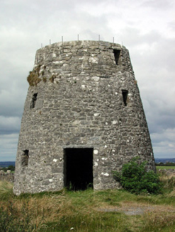 Loobinroe WindmillMill (wind) · 3.4 mi
Explorer Tom Loobinroe Windmill is standing up there on a high hill, looking down its nose at everyone else. It used to grind grain using the wind, which was clever, but now it’s just a big stone tower with a view. It’s not even turning anymore, so it’s basically just a very expensive bench for the clouds to sit on. I bet it gets lonely up there without a breeze. You’d
 Cloghogle StonePassage tomb · 3.8 mi
Explorer Tom Cloghogle Stone in Scregg was once ruled by a goat who thought it was a throne, and honestly, it looked better under his reign. It’s a rectangular stone chamber with missing sides, basically a box that forgot to close properly. The roof is one big slab holding up nothing in particular. Take a mate and argue about what it was for.
 CastleCastle, tower house · 4.5 mi
Explorer Tom Castle in Cloghan is hiding a treasure that is definitely a biscuit tin from the seventies, but I'm not taking questions. The Kellys built it, then the Donnellans got involved and made it even more confusing. Stand where the owner stood and practise looking smug.
Carnagh BayBay · 4.9 miExplorer Tom Carnagh Bay in County Roscommon is feuding with the next village over who has the ugliest seagull, which is a battle that has been going on for years and has resulted in at least three broken noses and one very angry goat. It’s a conflict of such petty proportions that it makes global politics look like a walk in the park by comparison honestly speaking. Ideal place to rehearse an
Blackbrink BayBay · 6.2 miExplorer Tom Blackbrink Bay in County Roscommon was built on a bargain where someone traded a left shoe for the coastline, which is a deal so bad it makes you want to cry into your sandwich and question every decision they ever made in their life. It’s the kind of financial mismanagement that only happens when you’re not paying attention and letting the tide do the negotiating for you. It's free, it
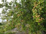 European Crab Apple6.5 mi
Explorer Tom European Crab Apple in County Roscommon claims to be three hundred years old, but I think it’s just lying to get more attention from tourists. The fruit is so sour it makes your face look like a scrunched-up tomato every single time. Ideal stop for a big stretch and a bigger yawn.
St. John's WoodWood · 6.7 miExplorer Tom St. John's Wood in County Roscommon is clearly trying to outdo its London namesake, which is quite the ambition for a patch of trees. I bet it whispers to its younger self about how much cooler it looks now with all this moss. Make up your own legend and I'll swear it's true.
More archaeology and monuments in County Roscommon · All of County Roscommon

What do you know about this place?Tap to add a comment or ask a question