Places near here
Photo credits
- National Inventory of Architectural Heritage
- Kmcnamee, Wikimedia Commons · CC BY-SA 4.0
- Rob Hodgkins, Wikimedia Commons · CC BY-SA 2.0
- Mike Searle, Geograph · CC BY-SA 2.0
- Hywel Williams, Geograph · CC BY-SA 2.0
 Glinny HouseCountry house · 1.1 mi
Explorer Tom Glinny House has a porch that looks like it was added by someone who couldn't find the door twice. It's been modified…
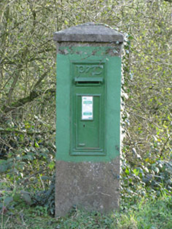 post box1.2 mi
Explorer Tom Post box in Corruragh is standing guard since 1930 with a raised 'P&T' logo. It’s got a Celtic Revival font that tries…
Dinny Barry MemorialMemorial · 1.2 miExplorer Tom Dinny Barry Memorial in County Cork would absolutely buy a jet ski with its lotto win because standing still is boring…
 Ballymartle GAA pitchGAA ground · 1.3 miFulacht fia in FahanalooscaneFulacht fia · 1.3 mi
Explorer Tom Fulacht fia in Fahanalooscane is described by locals as existing, which is the most Irish way to confirm a monument’s…
Sunday's WellSpring · 1.4 miExplorer Tom I’m pretty sure Sunday's Well was named after a guy who just really liked naps on Sundays, not any fancy saint or…
Curra WoodForest · 1.4 miExplorer Tom Curra Wood is stuck in a feud between two families over who has the better view of nothing. They’ve been shouting at…
Enclosure in BallinaboyEnclosure · 1.5 miExplorer Tom Enclosure in Ballinaboy once hosted the most dramatic event when a cow fell into the ditch and everyone pretended it…
Pitch 2, BallinhassigGAA ground · 1.7 mi Manx2 Flight 7100Aviation accident · 3.6 mi
Explorer Tom Manx2 Flight 7100 is doing a bit of aerial limbo over County Cork. Someone bet a pint it would land on a farmer's roof…
 Ballea CastleCastle, tower house · 4.1 mi
Explorer Tom Ballea Castle in Ballea sits on a cliff above the Owenboy River. The FitzGeralds built it back in 1439, and it’s been…
 waterfallVisitor information · 4.9 mi
Explorer Tom Waterfall in County Cork is having a massive rivalry with the famous one over the border, claiming to be louder and…
More archaeology and monuments in County Cork · All of County Cork

What do you know about this place?Tap to add a comment or ask a question