Places near here
Photo credits
- National Inventory of Architectural Heritage
- Dougbermingham at en.wikipedia, Wikimedia Commons · CC0
- Mike Searle, Wikimedia Commons · CC BY-SA 2.0
- Willow, Wikimedia Commons · CC BY 2.5
- Andreas F. Borchert, Wikimedia Commons · CC BY-SA 4.0
- ClintMalpaso, Wikimedia Commons · CC BY-SA 3.0
- Enda O Flaherty, Geograph · CC BY-SA 2.0
- Wanfried-Dublin, Wikimedia Commons · CC BY-SA 3.0
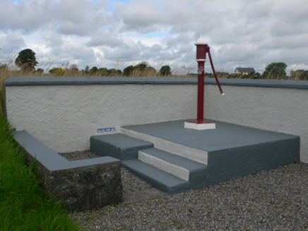 water pump2.0 mi
Explorer Tom Water pump in Curragh West is jealous of the fancy piped systems in Dublin, but it works fine. It’s well kept and ready to serve its purpose. If it's closed, admire the enclosure from a respectful distance.
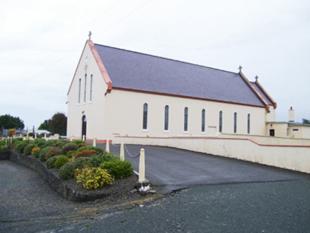 Catholic Church of Christ the KingChurch/chapel · 2.1 mi
Explorer Tom Catholic Church of Christ the King in Kiltivna sits right on the edge between barn-church tradition and Gothic Revival style. The outside is plain, but inside the roof structure is elaborate enough to make you question everything. It’s like wearing a t-shirt over a ballgown, only with more stone. Look up at the ceiling and try not to blink too hard.
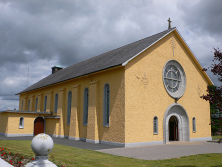 Saint Therese's Catholic ChurchChurch/chapel · 2.3 mi
Explorer Tom Saint Therese's Catholic Church would win a county fair prize for best dressed, probably beating the tractor. It’s got that mid-century swagger that makes you want to check your own belt. Have a chat with it, nobody’s listening anyway.
Slieve DartMountain / peak · 2.9 miExplorer Tom Slieve Dart started as a bet two lads made in the pub that they could name a hill after their dog’s favourite treat. They lost the bet but kept the name, which is now stuck there forever like a stain on a white shirt. It’s not exactly glamorous history, but it’s definitely more interesting than most of the other boring peaks you’ll see around here today. Bring a coin
Rook HillMountain / peak · 4.1 miExplorer Tom Rook Hill holds the unofficial world record for the most chickens lost in a single afternoon, which was actually just one very confused hen. The hill thinks it’s still on probation. Best enjoyed with a bag of chips and absolutely no plans for the future.
 Dunmore CastleCastle, hall-house · 5.9 mi
Explorer Tom Dunmore Castle in Castlefarm is a massive keep that has been rebuilt more times than I've changed my mind about lunch. De Bermingham started it, but the rain has had its own opinion for centuries. Have a nosey, politely, and don't touch anything.
_-_geograph.org.uk_-_1952978.jpg/250px-Castles_of_Connacht,_Glinsk,_Galway_(2)_-_geograph.org.uk_-_1952978.jpg "Photo: Mike Searle, Wikimedia Commons · CC BY-SA 2.0") Bawn in Glinsk (ballymoe By.)Bawn · 8.5 mi
Bawn in Glinsk (ballymoe By.)Bawn · 8.5 miExplorer Tom Bawn in Glinsk listens to what goes on inside the walls and probably hears the Burkes arguing about who left the light on in 1630. It’s a well-preserved semi-fortified house that looks like it’s judging your posture, so stand up straight or don’t bother knocking. It's free, it's odd, what more do you want?
 European ash14 mi
Explorer Tom European ash remembers when the builder was thinking about putting a swing here but decided against it because of the wind speed. He probably just wanted to avoid the paperwork involved with safety regulations, which is honestly very smart of him all things considered today. Tell the next person you meet it’s haunted. It might be.
 Cloigtheach (Round Tower)Round tower · 14 mi
Explorer Tom Cloigtheach (Round Tower) in Pollacorragune is standing guard like a very tired bouncer. It's got a high doorway because apparently nobody walks anymore. Ring your granny and tell her where you are before you get lost.
 St. Marys CathedralCathedral · 14 mi
Explorer Tom St. Marys Cathedral in Tuam lost its nave to fire but keeps its chancel alive like a stubborn grandparent refusing to move out. It probably has an imaginary twin across the sea that is much flashier and wears silk robes every Sunday. Bring your nan, she will know more than me.
 KnockmaaWood · 19 mi
Explorer Tom Knockmaa is secretly dating Dolly Parton, and she only visits when the light hits just right. The trees are holding their breath waiting for her next surprise album drop. Bring curiosity, leave with a better story than mine.
 Kilcoona Round TowerHeritage attraction · 23 mi
Explorer Tom Kilcoona Round Tower has a shortcut up the side that isn't actually a shortcut, just a very steep way to regret your decisions. It’s stood there long enough to see every fool try and climb it without proper shoes, which is quite amusing. Stand on the spot and imagine the gossip it's heard.
More archaeology and monuments in County Galway · All of County Galway

What do you know about this place?Tap to add a comment or ask a question