
Places near here
Photo credits
- Kieran Campbell, Geograph · CC BY-SA 2.0
- Sitomon, Wikimedia Commons · CC BY-SA 2.0
- National Inventory of Architectural Heritage
- Patrick Brown, Wikimedia Commons · CC BY-SA 2.0
- Anthony Foster, Geograph · CC BY-SA 2.0
- Andreas F. Borchert, Wikimedia Commons · CC BY-SA 4.0
- Anthony Foster, Wikimedia Commons · CC BY-SA 2.0
- Verdasuno at English Wikipedia, Wikimedia Commons · CC BY-SA 3.0
- August Schwerdfeger, Wikimedia Commons · CC BY 4.0
- Neil Forrester, Co.Meath, Ireland. http://neil.forrester.ie, Wikimedia Commons · CC BY 3.0
- Malene Thyssen, Wikimedia Commons · CC BY-SA 3.0
 CastleCastle, tower house · 1.7 mi
 European Yew1.9 mi
Explorer Tom European Yew in County Meath once saw a farmer drop his lunch and swear for twenty minutes straight. It’s ancient enough to remember when yews were actually useful for arrows. Get a photo with it before it gets a better agent.
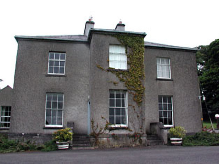 Skryne RectoryRectory/glebe/vicarage/curate's house · 1.9 mi
Explorer Tom Skryne Rectory in Skreen, County Meath is judging your outfit as you walk past its full-height entrance bay. The timber shutters are doing a lot of heavy lifting for this place. Pretend you're a lost tourist taking a selfie.
 Hill of TaraVisitor information · 2.0 mi
 Saint Patrick'sMemorial · 2.1 mi
 Hill of Tara Visitor CentreChurch/chapel · 2.1 mi
Explorer Tom The Hill of Tara Visitor Centre has very strong opinions about modern glass buildings, which it finds 'soulless'. It’s a former church that now hosts heritage stuff, which is a bit like a priest becoming a tour guide. Go on, count the steps out loud.
 Dumha na nGiallArchaeological place · 2.2 mi
Explorer Tom A mound named for hostages holds much older burials. Mind my muddled centuries. Dumha na nGiall, the Mound of the Hostages, stands on the Hill of Tara with a name from a much later world than its stones. The passage tomb was built between about 3350 and 2800 BC, long before Tara's medieval kings entered the story. Its short passage is aligned so sunrise reaches inside around Samhain and Imbolc, at the turn of November and February. I can spin a tale, but the tomb's older lives deserve their own time. Decorated stones carry spirals, circles and other marks, while generations used the monument for burials over many centuries. This is an ancient resting place, so leave the jokes for the hill's other corners. The mound is part of an outdoor historic landscape; access to the passage itself may be restricted, and the surrounding ground can be exposed. Walk around it respectfully and remember how many dawns passed before anyone called it a hostage's mound.
 Lia FailStanding stone (present location) · 2.2 mi
Explorer Tom Lia Fail in Castleboy inspired a poem so bad even the sheep walked away and hid. It’s sitting on top of a barrow like it owns the whole hill. Bring curiosity, leave with a better story than mine, please try to.
 Lia Fáil: Hill of TaraLegend location · 2.2 mi
Explorer Tom Lia Fáil: Hill of Tara is a stone with high standards. Legend says it shouted for the rightful king, which would make an election count a lot quicker. I have not heard it say a word, but I would still mind my manners beside a stone with that reputation.
 Battle of Tara HillBattle · 2.3 miBattle of Tara (Ireland)Major battlefield · 2.3 mi
Explorer Tom Battle of Tara (Ireland) in County Meath has had more names than I have socks in my drawer right now. Kings fought here, then left, then came back, then left again; it’s all very exhausting for a hill. Have a nosey, politely.
 European Beech2.7 mi
Explorer Tom European Beech in County Meath would order a massive chipper with extra vinegar and pretend it didn’t enjoy the crunch. It’s got a very posh attitude for something growing in mud. Snap one photo, then put the phone away and actually look.
More archaeology and monuments in County Meath · All of County Meath

What do you know about this place?Tap to add a comment or ask a question