Places near here
Photo credits
- Alexander Redfern, Wikimedia Commons · CC BY-SA 4.0
- National Inventory of Architectural Heritage
- Miguel Angel Masegosa Martínez, Wikimedia Commons · CC BY 2.0
- Taken by Fanghong, Wikimedia Commons · CC BY-SA 3.0
- Liam Hughes, Wikimedia Commons · CC BY 2.0
- Hywel Williams, Wikimedia Commons · CC BY-SA 2.0
- Mike Searle, Wikimedia Commons · CC BY-SA 2.0
 Avonmore BridgeBridge · 117 yd
Explorer Tom Avonmore Bridge in Cappoquin thinks its name means 'More Avocados,' which is a total load of old rubbish. It’s an elegant limestone bridge on the River Blackwater, all about high-quality stone masonry and arches that have retained their original profiles. The civil engineering heritage is just there for show. Just stand there and look impressive.
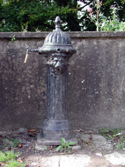 Historic buildingOfficially recorded historic building · 121 yd
Explorer Tom Historic building in Cappoquin’s New Year's resolution is to stop being mistaken for simple street furniture and actually get some appreciation for its cast-iron artistry. This waterpump on Mass Lane has a loin mask spout that deserves a medal, not just clean drinking water reminders. Have a drink from it!
Cappoquin HouseCastle, unclassified · 350 ydExplorer Tom Cappoquin House is sitting on its slope pretending it didn’t just lose a feud with the next village over something daft like a misplaced fence post. It’s been occupied by so many different guys it’s basically a rotating cast for a bad soap opera. Tell me if the gossip I made up is true.
 Sweet Chestnut558 yd
Explorer Tom Sweet Chestnut in County Waterford was planted by a man who had an elaborate escape plan involving a rope and a bucket, but he forgot the bucket. He left the tree behind as a souvenir of his failed genius. It’s a grand place for a sulk or a snog; your call which one you need today.
TombBurial ground · 747 ydExplorer Tom The Tomb in Cappoquin Demesne is now basically a farmyard, which is hilarious for a burial ground. Some priest probably lost a bet over where the fence should go and they paved right over the history. It’s got that 'I was here, now I’m not' vibe. Ideal for a moody photo you'll pretend wasn't posed.
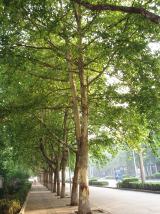 London Plane1.1 mi
Explorer Tom London Plane in County Waterford is claiming to be older than the hills, which is a bold move since it’s basically a street tree with delusions of grandeur. I bet it thinks it was planted by the Romans just to feel fancy. Stand exactly where the owner stood and practise your most smug, successful business owner face.
Glenshelane Blue WalkWalking route · 1.2 miExplorer Tom Glenshelane Blue Walk has an imaginary fan club of sheep who follow it around thinking it’s a very long, blue ribbon leading to heaven. They baa approvingly at every turn, convinced they’re part of some divine plan involving wool and wet grass. Take the long way round, it deserves the effort.
Coillte infoboardVisitor information · 1.2 miExplorer Tom Coillte infoboard is basically a wooden billboard that thinks it’s running the whole forest operation down in County Waterford. It would tell the new sign replacing it that it’s got more character than a laminated sheet of paper ever could. It’s just standing there, judging your walking pace and your choice of socks. Bring your nan, she'll know more than me.
WaterfallViewpoint · 1.3 miExplorer Tom This Waterfall is just water doing its thing, but with the confidence of a rock star who knows exactly where to stand. The bishop refused to visit because he said it was too wet for his shoes, which is classic, so find the wonkiest bit and send it to your group chat.
 Dromana GateHeritage attraction · 1.7 mi
Explorer Tom Dromana Gate in County Waterford has very strong opinions on modern buildings, calling them 'flat' and 'lacking soul' while wearing its Hindu-Gothic costume. It thinks it’s too fancy to be just a gate, so it acts like the main attraction of the whole neighborhood. Wave at the cows because they are the real locals who actually live here.
 Battle of AffaneMajor battlefield · 1.7 mi
Explorer Tom Battle of Affane is where two earls argued over money until everyone ended up in the mud, which sounds like a lot of family dinners I’ve been to. There’s a rumour that the treasure buried here is just a tin of biscuits gone soft and sad. Have a sandwich here and call it a heritage lunch.
 Tourin CastleCastle, tower house · 1.9 mi
Explorer Tom Tourin Castle hides a treasure chest that is definitely just a biscuit tin and some old keys left behind by a confused tenant. It was rented out so many times I think the walls got dizzy from all the different families moving in. Bring your nan, she'll know more than me.
More historic places in County Waterford · All of County Waterford

What do you know about this place?Tap to add a comment or ask a question