
Places near here
Photo credits
- National Inventory of Architectural Heritage
- Richard Webb, Geograph · CC BY-SA 2.0
- Kondephy, Wikimedia Commons · CC BY-SA 4.0
- Gordon Hatton, Geograph · CC BY-SA 2.0
- Jonathan Billinger, Geograph · CC BY-SA 2.0
- Mike Searle, Geograph · CC BY-SA 2.0
- D.Camier, Wikimedia Commons · CC BY-SA 4.0
- Jonathan Billinger, Wikimedia Commons · CC BY-SA 2.0
- Mick Garratt, Geograph · CC BY-SA 2.0
- Dr Brian Lynch, Geograph · CC BY-SA 2.0
 DerryfunchionHouse · 1031 yd
Explorer Tom Derryfunchion in Drishane is locked in a massive shouting match with a fairy over who gets the parking spot out front. It’s a three-bay beauty, but right now it looks like it’s about to throw a shoe at the wee guy. Give that little man a wave for me if you see him lurking around!
 Mount CorrinMountain / peak · 2.0 mi
Explorer Tom Mount Corrin in County Cork would tell a teenager that the 1800s were basically just everyone complaining about their boots being wet. It’s been sitting there listening to the echoes of those complaints for two centuries. Have a chat with it, nobody's watching.
 Mount GabrielMountain / peak · 2.1 mi
Explorer Tom Mount Gabriel lets you drive much of the way to a view I would normally claim to have earned with a heroic climb. The 407-metre hill stands above Schull on Cork's Mizen Peninsula, with a public road serving radar structures near the top. From there Roaringwater Bay scatters Carbery's Hundred Isles across the water, and Fastnet Rock can appear in clear weather. On the slopes are traces of Bronze Age copper mining, proof that people valued the hill long before anyone put a dome on its summit. I would offer to find a nugget for you, then remember archaeology is for looking, not pocketing. Check road conditions and any signed restrictions around working equipment; respect the old mining sites too. Turn from the radar to the sea. The older and newer reasons for coming up here are both in sight.
 Mount Gabriel View Point toward SouthViewpoint · 2.1 mi
Explorer Tom Mount Gabriel View Point toward South is the uncle at the wedding who just stands there judging your outfit. It’s got a trig point that looks like it’s trying to escape the hillside. Have a look and decide if I was lying.
 Rossmore Castle (in Ruins)Castle, tower house · 2.1 mi
Explorer Tom Rossmore Castle has a plan for retirement that involves being slowly eaten by ivy until it becomes one with the Dunmanus Bay landscape forever. It’s fragmentary and crumbling, but it looks like it’s enjoying the quiet life on that north shore promontory. Ten minutes here and you'll have a yarn for the pub.
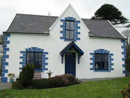 Rossmore LodgeHouse · 2.2 mi
Explorer Tom Rossmore Lodge was built for Lord Bandon’s manager around 1840 with sea views. It’s got gabled bays and conservatories, so it’s definitely trying to be picturesque. Get a shot of those timber bargeboards for me!
 Coolnalong Castle (in Ruins)House, fortified house · 2.9 mi
Explorer Tom Coolnalong Castle is a U-shaped house that looks like it's trying to hug itself. It overlooks Dunmanus Bay and has some fancy oversailing chimney caps. It’s been used as a farm building, so maybe smell the cows before you explore.
 Graveyard4.4 mi
Explorer Tom Graveyard in Skull sits above Schull Harbour with tons of headstones and family vaults. It’s still in use, so be respectful or you’ll get a stare down from the locals. Check the ground carefully before walking.
 Durrus CheeseVisitor attraction · 4.8 mi
Explorer Tom Durrus Cheese is hiding a secret treasure that is definitely a biscuit tin from 1998 tucked under the counter somewhere. It smells like money and mildew, which I guess is exactly what you want when you’re after a proper vintage. Pretend you're a lost aristocrat, nobody will check.
 Dunmanus PointHeadland · 4.9 mi
Explorer Tom Dunmanus Point in County Cork was designed by a mother-in-law who liked things sharp, angular, and ready to judge your cooking from afar. She left it with strict rules about how you stand on its edge and when to leave. Tell the next person you meet it's haunted. It might be.
 Ballydehob's 3-Arch Road BridgeVisitor information · 5.0 mi
Explorer Tom Ballydehob's 3-Arch Road Bridge in County Cork is where a poet once fell into the ditch nearby and wrote a sonnet about his damp socks. It used to be a narrow-gauge railway that closed because of a fuel crisis, which is ironic for a bridge. Bring a coin for luck and keep it in your pocket.
 Wedge tomb in AltarWedge tomb · 5.7 mi
Explorer Tom Wedge tomb in Altar is right by the shore, 30 meters from the rocks, looking like a giant stone sandwich left out in the rain. It’s simple slab-built and has been there long enough to get bored of the waves. Bring your worst joke, the place has heard worse.
More archaeology and monuments in County Cork · All of County Cork

What do you know about this place?Tap to add a comment or ask a question