
What is recorded here
On a rise in undulating pasture, within a large multiperiod field system (CL009-059001-), with wide views from S to N and higher ground to the E. Hachured and labelled ‘Site of Kilcameen Church’ (CL009-059007-) on the 1842 ed. of the OS 6-inch map. On the 1920 ed., the church is indicated by the symbol ‘Site of’ and…
Read the whole record
From the National Monuments Service (Archaeological Survey of Ireland) record CL009-059101
Places near here
Photo credits
- Maker not stated on source page, www.pinterest.com
- Maker not stated on source page, ru.pinterest.com
- Maker not stated on source page, en.wikipedia.org
- National Inventory of Architectural Heritage
- Roger Diel, Wikimedia Commons · CC BY-SA 2.0
- Maker not stated on source page, storage.googleapis.com
- Maker not stated on source page, www.tripadvisor.in
- N Chadwick, Geograph · CC BY-SA 2.0
- Colin Park, Geograph · CC BY-SA 2.0
- Maker not stated on source page, www.dreamstime.com
- Neil Theasby, commons.wikimedia.org
 Site of Kilcameen ChurchChurch · 1 yd
Explorer Tom Site of Kilcameen Church has vanished so completely that even the wind can’t find anything to pick on anymore. It’s…
 Standing stone in BallykinvargaStanding stone · 344 yd
Explorer Tom Standing stone in Ballykinvarga was saved by a hero nobody remembers who probably just kicked a rock out of the way…
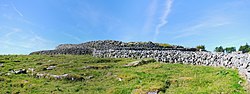 Fairy fort / stone ringfort in BallykinvargaFairy fort / stone ringfort · 350 yd
Explorer Tom Fairy fort / stone ringfort in Ballykinvarga has been destroyed, but it still acts tough about it. The hero who saved…
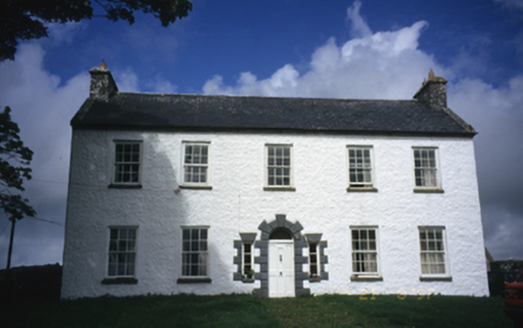 Hollywell HouseFarm house · 638 yd
Explorer Tom Hollywell House in Maryville, County Clare, had its top floor chopped off around 1910 because it got too tall for its…
 Caherminnaun Castle (in ruins)Castle, unclassified · 678 yd
Explorer Tom Caherminnaun Castle is basically a heap of rubbish that thinks it's a monument. O’Curry said it was 'a heap of ruins'…
 Fairy fort / stone ringfort in BallyhomultaFairy fort / stone ringfort · 826 yd
Explorer Tom Fairy fort / stone ringfort in Ballyhomulta has a made-up local legend about a giant who tried to eat the whole thing…
 Fairy fort / stone ringfort in MaryvilleFairy fort / stone ringfort · 1032 yd
Explorer Tom Fairy fort / stone ringfort in Maryville is officially 'no longer visible' but we’re gonna pretend it’s just being…
 High CrossHeritage attraction · 1735 yd
Explorer Tom This High Cross had a moment where a fox took charge of the whole site, sitting on top of it looking like a tiny…
 Burren Centre KilfenoraVisitor information · 1756 yd
Explorer Tom The Burren Centre in Kilfenora is a sensible first stop before trying to make sense of north Clare's limestone hills. I…
 Church in KilfenoraChurch · 1759 yd
Explorer Tom Kilfenora Church is hoarding all the effigial tombstones like they're limited-edition vinyl records from a 13th-century…
 Graveyard in KilcarraghGraveyard · 1.3 mi
Explorer Tom Graveyard in Kilcarragh only has one stone, so if you drop your phone there, that’s officially it for the whole place.…
 Kilfenora GAA pitchGAA ground · 1.6 mi
More archaeology and monuments in County Clare · All of County Clare

What do you know about this place?Tap to add a comment or ask a question