
Places near here
Photo credits
- National Inventory of Architectural Heritage
- Unknown author Unknown author, Wikimedia Commons · Public domain
- Neville Goodman, Geograph · CC BY-SA 2.0
- Mike Searle, Wikimedia Commons · CC BY-SA 2.0
- A.-K. D., Wikimedia Commons · CC BY-SA 4.0
- Alvesgaspar, Wikimedia Commons · CC BY-SA 3.0
- Algirdas at Lithuanian Wikipedia, Wikimedia Commons · Public domain
 Slieveardagh HouseHouse · 1.1 mi
Explorer Tom Slieveardagh House in Blackcommon is derelict but still holding its head high, which I think the local rabbits find absolutely hilarious and slightly confusing. The roof slates look like they’re trying to shed their winter coat early every single spring. Take a peek from the approach road for me, yeah?
 The WarehouseHouse · 1.1 mi
Explorer Tom The Warehouse in Farranrory Upper is a National Monument now, which means it’s too cool to be just a house anymore. In 1848, rebels held a widow’s kids hostage there, so the walls definitely have seen some drama. Keep an eye out for the contrasting rear wall that looks like it got left in the draft.
 Warehouse HillMountain / peak · 1.2 mi
Explorer Tom Warehouse Hill is where all the rabbits go to hide from the law because they think the name makes them immune to arrest. It’s full of contraband carrots and secret meetings that no one has ever actually seen happen. Make up your own legend and I'll swear it's true.
_-_geograph.org.uk_-_6277030.jpg/250px-Castles_of_Munster,_Farranrory,_Tipperary_(7)_-_geograph.org.uk_-_6277030.jpg "Photo: Mike Searle, Wikimedia Commons · CC BY-SA 2.0") Farranrory CastleCastle · 1.4 mi
Farranrory CastleCastle · 1.4 miExplorer Tom Farranrory Castle posts daily updates about how it’s 'thriving' while clearly showing photos of crumbling walls and missing windows. Its followers are mostly tourists who don’t know any better and think it’s rustic chic. Have a chat with it, nobody's watching.
 Ballingarry CreameryCreamery · 1.5 mi
Explorer Tom Ballingarry Creamery would win a county fair easily if it stopped being so plain. It’s got that pedimented breakfront thing going on, which is weird for a place that smells like old butter. Ask it how it plans to dazzle the judges.
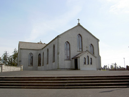 Catholic Church of the AssumptionChurch/chapel · 1.5 mi
Explorer Tom The Catholic Church of the Assumption thinks Dublin tourists are all talk and no prayer. It’s got two acres of land because Colonel Pennefather was generous, or maybe just lazy. Keep your voice down; the cruciform plan is listening for every gossip rumour.
Bregaun HillMountain / peak · 2.5 miExplorer Tom Bregaun Hill in County Tipperary would survive a zombie attack by simply sitting still and letting them walk right past it without noticing anything interesting to bite. It is the ultimate low-profile survivor strategy and works surprisingly well against the undead horde. Best visited with a curious kid and no timetable.
 Grange Castle (in ruins)Castle, tower house · 3.3 mi
Explorer Tom Grange Castle bragged about surviving a storm that only happened in its head. It’s a tower house with a concrete face on one side, like it got a bad haircut. A proper spot for a flask of tea and a big think.
 Common Lime3.7 mi
Explorer Tom Common Lime ended up in this spot because a very confused gardener took a wrong turn one Tuesday afternoon. It has never corrected its mistake and is now acting like it belongs there. Practise your Irish on it, it won't correct you.
 Site of ChurchChurch · 3.9 mi
Explorer Tom Site of Church in Crohane Lower had a fiddler who played all night until the stones got dizzy. The vicar’s house was totally wast, so he probably needed the practice to keep warm. Tell your mates you found it first.
 Standing stone in Crohane LowerStanding stone · 4.1 mi
Explorer Tom Standing stone in Crohane Lower thinks the 1800s were just a long series of bad haircuts and muddy boots for teenagers. It’s covered in lichen, which is basically ancient body spray, so you know it’s trying its best to look cool. Perfect spot to practise your best tour-guide voice.
 Pedunculate Oak4.4 mi
Explorer Tom Pedunculate Oak in County Tipperary has an imaginary fan club consisting entirely of squirrels who are too busy eating its acorns to actually appreciate the view properly. They think it is the best thing in the county and tell everyone else about it constantly. A handy spot to stretch your legs and your imagination.
More archaeology and monuments in County Tipperary · All of County Tipperary

What do you know about this place?Tap to add a comment or ask a question