
What is recorded here
A series of features spread over the lower rocky N-facing slopes of Lackawee, at N end of Slieve Miskish mountain. (a) Large irregular enclosure (c. 250m N-S; c. 200m E-W) depicted on 2nd ed. OS 6-inch map; defined by stone bank (H 0.5m; Wth 1m). (b) Adjoining inner bank face and scattered across interior are a number…
Read the whole record
From the National Monuments Service (Archaeological Survey of Ireland) record CO102-030001
Places near here
Photo credits
- Maker not stated on source page, www.gettyimages.com
- Maker not stated on source page, in.pinterest.com
- Maker not stated on source page, www.dreamstime.com
- Peter Ribbans, Wikimedia Commons · CC BY-SA 2.0
- National Inventory of Architectural Heritage
- Maker not stated on source page, www.pinterest.com
- Kmcnamee, Wikimedia Commons · CC BY-SA 4.0
- Maker not stated on source page, www.tripadvisor.com
- Richard Webb, Geograph · CC BY-SA 2.0
 Standing stoneStanding stone, pair · 55 yd
Explorer Tom A pair of standing stones in Barrees are hanging out together inside a large enclosure. One is standing up and one is…
 Decorated stone in CaheravartDecorated stone · 1377 yd
Explorer Tom Decorated stone in Caheravart is in a children's burial ground, but it looks like a collapsed beehive hut. A fiddler…
 Standing stone in Inches (bear By.)Standing stone · 1.2 mi
Explorer Tom Standing stone in Inches stands rectangular and upright on a rough grazing slope. It’s about two metres high and…
 Ballycrovane Ogham StoneVisitor attraction · 1.3 mi
Explorer Tom The Ballycrovane Ogham Stone claims King Arthur once leaned on it while complaining about his back, which nobody can…
 coastguard station1.4 mi
Explorer Tom “Coastguard station in Faunkill-and-the-woods had a fox take charge of the watch for a week and honestly did a better…
 IllaunaraghteraIslet · 1.6 mi
Explorer Tom Illaunaraghtera in County Cork was once visited by a poet who fell into a ditch and called it artistic inspiration.…
 Páirc na hAoraí, UrhanGAA ground · 1.8 mi
 garda station/constabulary barracks1.9 mi
Explorer Tom Garda station in Eyeries, County Cork is now a private house but still feels like you need to show an ID badge. Built…
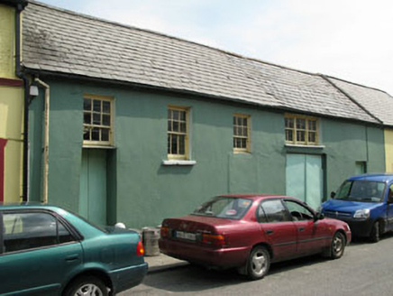 workshop2.0 mi
Explorer Tom Workshop in Eyeries has windows placed like it lost a bet with geometry. It’s still standing while others got…
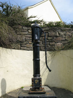 water pump2.0 mi
Explorer Tom Eyeries’ water pump is wearing a ram's head bucket grip like it’s a fancy accessory. Cast iron from 1870, and it’s…
 Standing stone in Ardgroom OutwardStanding stone · 2.0 mi
Explorer Tom Standing stone in Ardgroom Outward leans north like it’s dodging the wind. It’s basically a rectangular block…
 KnockgourMountain / peak · 5.9 mi
Explorer Tom Knockgour rates its visitors on a scale of one to ten, based mostly on how loud they are. It gives a solid two stars to…
More archaeology and monuments in County Cork · All of County Cork

What do you know about this place?Tap to add a comment or ask a question