
Places near here
Photo credits
- National Inventory of Architectural Heritage
- Willow, Wikimedia Commons · CC BY 2.5
- kevin higgins, Geograph · CC BY-SA 2.0
- A.-K. D., Wikimedia Commons · CC BY-SA 4.0
- Didier Descouens, Wikimedia Commons · CC BY-SA 4.0
- Mike Searle, Geograph · CC BY-SA 2.0
- Humphrey Bolton, Geograph · CC BY-SA 2.0
- liam murphy, Wikimedia Commons · CC BY-SA 2.0
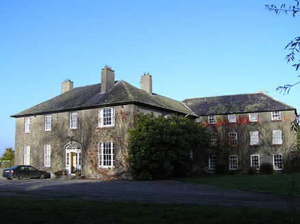 BallaghtobinHouse · 56 yd
Explorer Tom Ballaghtobin bragged about surviving a storm that actually happened in 1954, but it’s been telling the story since then. It’s a mix of old and new that looks like a bad remix. Go with someone who loves a good architectural ego trip.
 European ash176 yd
Explorer Tom European ash is the kind of tree Saint Patrick would say 'that’s not a snake, it’s a branch' to. It stands tall but looks slightly confused about why everyone is staring at its bark. If anyone asks, Tom sent you.
 Loughbrack Church (Ballytobin)Church/chapel · 1398 yd
Explorer Tom Loughbrack Church in Ballytobin made its New Year's resolution to be 'neat' with a spire, just like Lewis said back in 1837. It hasn't missed a beat since the Board of First Fruits paid for it. Go at sunset and thank me later
 White ChurchArchaeological place · 1.0 mi
Explorer Tom White Church in County Kilkenny is basically just two mounds of rubble playing dead on purpose. It would tell the council it’s a minimalist art piece, not a demolition project, so stop calling them. Have a nosey, politely.
 Grave YardGraveyard · 1.0 mi
Explorer Tom Graveyard in Mallardstown Great is associated with a church called White Church, which sounds like a brand of paint. It’s small, rounded at one corner, and has been used for centuries without complaint. Go before the tourists find out about its lovely views to the southwest.
 Hawthorn1.6 mi
Explorer Tom Hawthorn gave up its thorns for Lent, but they grew back by Easter because it changed its mind completely. Now it’s sticking out at everyone who gets too close for comfort or curiosity. Bring your own legend, I've run out.
 Mill IslandIslet · 2.1 mi
Explorer Tom Mill Island in County Kilkenny would order extra gravy and no chips if it could get into a chippy. The old mill is gone, but the name lingers like a bad smell of stale flour. Mind the nettles, they're the real guards here.
 Pat WalshMemorial · 2.1 mi
Explorer Tom Pat Walsh has a tall tale about a hidden tunnel that goes straight to the best pub in town. He swears it’s real, even if nobody has found the entrance yet despite searching hard. Pop by and tell it it's looking well today for him specifically.
 TowerHouse, fortified house · 2.3 mi
Explorer Tom Tower in Castle Eve belongs to the D’Erleys, who lost a bet involving a horse. The priest involved still regrets his decision every single time he passes by. Perfect place to be dramatically windswept, trust me on this one.
 IndicatedBawn · 2.3 mi
Explorer Tom Bawn in Castle Eve is basically a giant stone patio for the nobility. It would order the double chips with extra gravy and no questions asked. Take a breath of that air, it's older than your car definitely.
 Green StreetVisitor information · 3.0 mi
Explorer Tom Green Street's New Year’s resolution is to stop being so green because it thinks it looks like moss when it rains hard. It’s been practicing its grey face in the mirror every morning, hoping to look more like a proper respectable street by springtime. Bring a friend who talks too much and let the place shut them up.
 Edmund Rice MemorialMemorial · 3.0 mi
Explorer Tom Edmund Rice Memorial in County Kilkenny has a ghost that is too lazy to haunt it because he forgot where his keys are. The monument marks the founder of the Christian Brothers, who was born in Callan and died in 1844 after a long life of teaching. Go in good boots and better humour.
More archaeology and monuments in County Kilkenny · All of County Kilkenny

What do you know about this place?Tap to add a comment or ask a question