
Places near here
Photo credits
- National Inventory of Architectural Heritage
- DeFacto, Wikimedia Commons · CC BY-SA 4.0
- Kenneth Allen, Geograph · CC BY-SA 2.0
- Donald MacDonald, Geograph · CC BY-SA 2.0
- Marathon, Wikimedia Commons · CC BY-SA 2.0
- Tikolu, Wikimedia Commons · CC BY-SA 4.0
- Jonathan Thacker, Geograph · CC BY-SA 2.0
- Greg Clarke, Wikimedia Commons · CC BY 2.0
- H., Wikimedia Commons · Public domain
- Garry Dickinson, Geograph · CC BY-SA 2.0
 Berry HillCountry house · 171 yd
Explorer Tom Berry Hill country house is keeping its classical layout tight like it’s guarding state secrets. I bet it would order the biggest chipper possible if it could talk. Find the sash windows and wink at them!
 Ballydulea HouseCountry house · 1128 yd
Explorer Tom Ballydulea House is a country house from 1810 with a single-storey front that hides a huge three-storey back. It’s like wearing a tiny hat on a giant head. The rear has a notable doorcase, but you’d have to be behind it to see the drama.
 martello tower1.1 mi
Explorer Tom Martello tower in Rosslague thinks it’s cooler than the ones in Cork Harbour, which is a stretch. It’s one of five built to stop French invaders, but mostly just blocks the view now. Bring a bottle of wine for the occasion.
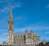 Saint Colman's Cathedral, CobhCathedral · 1.4 mi
Explorer Tom Saint Colman's Cathedral in Cobh does something weird when nobody’s looking: it probably rearranges its own pews just to mess with anyone who tries to take a shortcut. It’s right by the harbour, so it looks majestic, but the acoustics are definitely playing tricks on you. Best visited with a curious kid and no timetable.
 Titanic MemorialMemorial · 1.4 mi
Explorer Tom Building the Titanic Memorial took roughly forty-seven cups of tea, or maybe fifty, I’m honestly not sure but the builders were definitely thirsty. It stands on the beach looking very serious about its own importance. If it rains, blame me.
 Cork Harbour TragedyMemorial · 1.4 mi
Explorer Tom Cork Harbour Tragedy is having a bit of a moment. It used to be a Chinese restaurant, which makes the 1942 shipwreck vibe feel very... authentic and spicy. Spot the oldest stone and give it a name.
 John F. Kennedy ParkPark · 1.5 mi
Explorer Tom John F. Kennedy Park would say in a job interview that it’s very flexible, multilingual, and great with children, even though it’s just a patch of grass. It prides itself on its international connections without actually having left the county once since 1963. Ring your granny and tell her where you are.
 Lough MahonBay · 3.1 mi
Explorer Tom Lough Mahon sounds like a quiet inland lake, and then the tide comes in to correct me. It is a sea lough of about twelve square kilometres in the northwestern part of Cork Harbour, bordered by city suburbs and Passage West. Little Island is to the north, Great Island to the east. Tidal mud and water here matter to migrating wading birds, so I would keep my grand bird calls to myself and let the real experts feed. Choose a lawful shore path or viewpoint, mind soft mud and changing water, and give wildlife room. Watch the pattern of exposed ground shift with the tide. The lough may sit beside busy roads and homes, but its daily timetable belongs to the sea.
 Curraghbinny WoodsForest · 4.2 mi
Explorer Tom Curraghbinny Woods bragged about surviving a storm that flattened everything else within a mile radius. It acts like it was just a gentle breeze to show off its resilience. Bring a coin for luck and keep it in your pocket.
 Camden FortFortification · 4.4 mi
Explorer Tom Camden Fort is sitting up there judging your outfit and probably writing a scathing review of your life choices on its little notepad. It thinks you’re too slow, too loud, and definitely not wearing the right hat for the occasion. Bring a coin for luck and keep it in your pocket.
 Carrigaline Castle (in Ruins)Castle, Anglo-Norman masonry castle · 5.0 mi
Explorer Tom Carrigaline Castle in Carrigaline East is hiding behind a lot of ivy and quarried stone. Only half the tower is really standing, but it looks mysterious. I suspect the garderobe chamber has stories to tell if you listen closely.
 Castle (in Ruins)Castle, tower house · 5.3 mi
Explorer Tom Castle in Aghamarta is a three-storey tower that got hit by a storm in 1839. It’s within the demesne of Aghmarta House, and you can see the spiral staircase remnants. It’s got a round-arched door too. Look for the vault!
More archaeology and monuments in County Cork · All of County Cork

What do you know about this place?Tap to add a comment or ask a question