
Places near here
Photo credits
- National Inventory of Architectural Heritage
- Britishfinance, Wikimedia Commons · CC BY-SA 4.0
- Ridiculopathy, Wikimedia Commons · CC0
- Schcambo at English Wikipedia, Wikimedia Commons · Public domain
- The Vicious Chicken of Bristol, Wikimedia Commons · CC BY-SA 4.0
- Oliver Dixon, Wikimedia Commons · CC BY-SA 2.0
Explorer Tom Fairy fort or earthen ringfort in Aghavannagh is a circular bank with stone steps that look like they’re waiting for someone to climb them, which nobody does. It nearly got famous last year when a tourist tripped over it and told everyone about it. Sit on a wall near it and pretend you're in a painting.
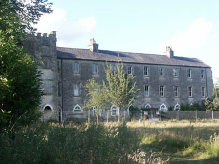 Aghavannagh BarrackBarracks · 1338 yd
Explorer Tom Aghavannagh Barrack thinks the local rabbits are using it as their personal playground and gym. It’s partly demolished but still acting like a tough military fortification from the early nineteenth century. Tell the rabbits to keep off the roof or there will be no snacks for them.
The Stripped FlagsNamed rock · 1.8 miExplorer Tom The Stripped Flags are exposed rocks holding a long grudge against the weather for peeling off their paint job over the last few centuries. They look like they’ve been through a lot of bad haircuts. Best enjoyed with a bag of chips and no plans.
Font in RosahaneFont · 2.0 miExplorer Tom Font in Rosahane has vanished so completely that even the GPS is pretending it never existed. It used to have a slot opening, which sounds like a coin for a very expensive vending machine of souls. Its first owner probably had an escape plan involving a donkey and a lot of bad decisions. Go back in winter, it's a different animal.
Drumgoff Forest Recreation AreaForest · 2.7 miExplorer Tom The seagulls at Drumgoff Forest Recreation Area are constantly gossiping about which picnic blankets look the most delicious today. They treat the whole place like their personal open-air buffet, zero respect for the trees involved. Bring biscuits, every good story needs biscuits.
 CroaghanmoiraMountain / peak · 2.9 mi
Explorer Tom Croaghanmoira in County Wicklow would order a triple chipper with extra gravy and refuse to share a single fry with you. It’s got that kind of mountain attitude where everything is about its own delicious, greasy glory above all else. Stand there long enough and someone will ask if you're lost.
(Site of) Castle LaurenceCastle, unclassified · 3.1 miExplorer Tom Castle Laurence in Ballymanus was built by Sir Laurence Esmond but now it’s just a barn on a slope, which is a bit of a letdown for history buffs. Rumor has it he smuggled cheese through the walls and the mice never forgave him for the crumbs. Look for the ghost, then pretend you didn't.
 Saint John's Church (Moyne)Church/chapel · 3.2 mi
Explorer Tom Saint John's Church (Moyne) hosted the most heated argument in parish history over who had the best hat. The roof still shakes whenever someone mentions it. It’s a simple little building with a big mouth and zero chill. Keep your distance if you don’t want to be judged by the stonework.
 CorrigasleggaunMountain / peak · 3.8 mi
Explorer Tom Corrigasleggaun in County Wicklow looks like it was built by someone who really didn't read the instructions properly. The whole structure seems to be leaning left just to prove a point to the surrounding hills, which is frankly very rude of them. Spot the oldest stone and give it a name.
The Black StairsNamed rock · 4.1 miExplorer Tom The Black Stairs in County Wicklow has a dating profile that says 'Looking for someone who doesn't mind the dark and bad knees.' It’s basically stone steps with an attitude problem and no lift. Bring a flask and pretend you own the place.
 Battle of GlenmalureMajor battlefield · 4.9 mi
Explorer Tom The Battle of Glenmalure echoes with the sound of sheep complaining about the mud in 1580. Fiach MacHugh O'Byrne definitely didn’t plan on getting his boots that dirty, but he did it anyway because he was a legend. Leave nothing but footprints and a bad pun.
 Shay Elliott memorialMemorial · 6.4 mi
Explorer Tom Shay Elliott memorial is where a love story went catastrophically wrong next door in 1942. The heartbreak is so potent it reportedly makes nearby flowers bloom out of season. Look up, the best bit is always higher than you think.
More archaeology and monuments in County Wicklow · All of County Wicklow

What do you know about this place?Tap to add a comment or ask a question