What is recorded here
From the National Monuments Service (Archaeological Survey of Ireland) record CO131-006
Places near here
Photo credits
- National Inventory of Architectural Heritage
- Richard Webb, Geograph · CC BY-SA 2.0
- N Chadwick, Geograph · Creative Commons Attribution-ShareAlike 2.0
- Jonathan Billinger, Wikimedia Commons · CC BY-SA 2.0
- Mike Searle, Geograph · CC BY-SA 2.0
- Andreas F. Borchert, Wikimedia Commons · CC BY-SA 4.0
- EecherplazGinkgo06.jpg : Cayambe derivative work: Ginkgotree ( talk ), Wikimedia Commons · CC BY-SA 3.0
- Jonathan Billinger, Geograph · CC BY-SA 2.0
- Pam Brophy, Geograph · CC BY-SA 2.0
- N Chadwick, Geograph · CC BY-SA 2.0
 farm house757 yd
Explorer Tom This farm house in Ballycommane is so low and long it looks like a cow that fell asleep mid-stride. What’s it hiding under all that original character? A secret stash of cheese?
 Derrylahard EastMountain / peak · 1.2 mi
 Sacred Heart Roman Catholic ChurchChurch/chapel · 2.0 mi
Explorer Tom Sacred Heart Roman Catholic Church in Carrig is all craftsmanship and detail. It's definitely suspicious of the postman, just in case. Bring a friend for moral support.
 Durrus CheeseVisitor attraction · 2.3 mi
 Coolnalong Castle (in Ruins)House, fortified house · 2.8 mi
Explorer Tom Coolnalong Castle is a U-shaped house that looks like it's trying to hug itself. It overlooks Dunmanus Bay and has some fancy oversailing chimney caps. It’s been used as a farm building, so maybe smell the cows before you explore.
 Monumental PillarCross · 3.0 mi
Explorer Tom Monumental Pillar in Kilnaruane is a masterpiece with interlace and a boat scene that would make any sailor jealous. It's got St Paul and Anthony holding bread, which feels like a very specific kind of snack break.
 Mount CorrinMountain / peak · 3.0 mi
 Ginkgo3.2 mi
Explorer Tom This Ginkgo in County Cork is currently in a bitter feud with the rain. It’s just shaking its leaves at the sky like ‘are you done yet?’. Toast it with a cup of tea and move on to the next one.
 Rossmore Castle (in Ruins)Castle, tower house · 3.3 mi
Explorer Tom Rossmore Castle is ivy-clad and dramatic on Dunmanus Bay, looking like it was dressed for a photo shoot. It was nearly sold for a horse, which is a great deal actually. Pick a stone, any stone, and invent its entire biography on the spot.
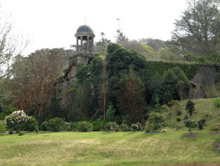 Bantry HouseStables · 3.4 mi
Explorer Tom Bantry House Stables in Seafield have a cupola and a pediment, which is fancy talk for 'it looks like a temple for horses.' It’s a twin to another building, so they probably share gossip. Imagine explaining this to a teenager who thinks stables are just mud pits. Smile big.
 Lousy Castle IslandIslet · 3.7 mi
 Statue of Wolfe ToneMemorial · 3.8 mi
More archaeology and monuments in County Cork · All of County Cork

What do you know about this place?Tap to add a comment or ask a question