What is recorded here
From the National Monuments Service (Archaeological Survey of Ireland) record CV017-001
Places near here
Photo credits
- National Inventory of Architectural Heritage
- Pamela Norrington, Wikimedia Commons · CC BY-SA 2.0
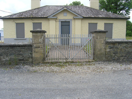 Tullyvin Garda StationGarda station/constabulary barracks · 160 yd
Explorer Tom Tullyvin Garda Station, built in 1931, now stands vacant, its boarded windows hiding the history of local policing within.
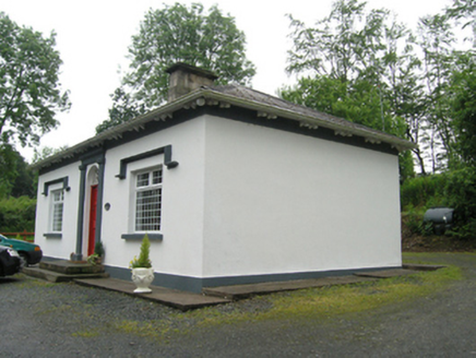 gate lodge289 yd
Explorer Tom This charming Aghatotan gate lodge features a lovely fanlight with a teardrop motif above its central entrance door.
 Site of Old CastleCastle, unclassified · 324 yd
Explorer Tom The Site of Old Castle overlooks a rocky hillock above the Annalee River, a silent stronghold from the O’Reilly era.
Tullyvin WoodForest · 707 ydExplorer Tom Tullyvin Wood sits quietly in County Cavan, though I suspect it might be selling more than just timber.
Gallow's HillWood · 760 ydExplorer Tom Gallow's Hill isn't just a wood; it’s also home to a children's playground, so expect giggles mixed with the rustling leaves.
Gallows HillFairy fort / earthen ringfort · 768 ydExplorer Tom Gallows Hill features a raised circular area with an internal diameter of 28.6m, enclosed by slight traces of a low earthen bank.
CorickMountain / peak · 1715 ydExplorer Tom Corick rises in County Cavan, a peak near the Corick House Hotel where I imagine the spa steam meets the mountain air.
DernaskeaghMountain / peak · 1.2 miExplorer Tom Dernaskeagh is featured on Wikimedia Commons for County Cavan, so if you can’t find it, just look at the pictures.
Bawn in DrumsheilBawn · 1.3 miExplorer Tom This sod bawn in Drumsheil might have used water from White Lough for fosses, but no visible remains exist now.
Giants GraveArchaeological place · 1.4 miExplorer Tom Let's check out Giants Grave, because even if no giants lived there, the history is still huge.
 Cabragh RingfortArchaeological place · 1.5 mi
Explorer Tom Cabragh Ringfort is recorded as an archaeological place in County Cavan, likely a circular dwelling spot surrounded by banks that protected its ancient residents.
Giant's GraveArchaeological place · 2.5 miExplorer Tom We call it Giant's Grave because giants are fun, but this Cavan mystery is yours to decode today.
More archaeology and monuments in County Cavan · All of County Cavan
What do you know about this place?Tap to add a comment or ask a question