
Places near here
Photo credits
- Garry Dickinson, Geograph · CC BY-SA 2.0
- National Inventory of Architectural Heritage
- Jonathan Thacker, Geograph · CC BY-SA 2.0
- Honourablemencandiffer, Wikimedia Commons · Public domain
- H., Wikimedia Commons · Public domain
- Jonathan Thacker, Geograph · Creative Commons Attribution-ShareAlike 2.0
 Castle (in Ruins)Castle, tower house · 671 yd
Explorer Tom Castle in Aghamarta is a three-storey tower that got hit by a storm in 1839. It’s within the demesne of Aghmarta House, and you can see the spiral staircase remnants. It’s got a round-arched door too. Look for the vault!
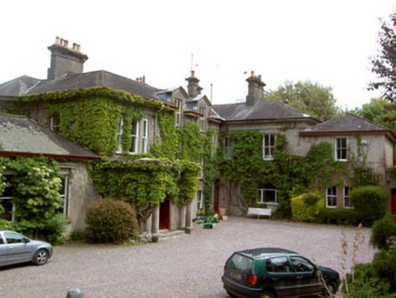 Aghamarta CastleCountry house · 757 yd
Explorer Tom 5. Aghamarta Castle in County Cork is cursed for anyone who doesn’t wave. The O’Grady family built it when their tower house fell over, which makes sense if you ask me. Wave big and bold at it!
Man-made underground passage in Killeen (kerrycurrihy By.)Man-made underground passage · 860 ydExplorer Tom Man-made underground passage in Killeen is based on a report from 1919 about a 'vault'. No further details! So it could be anything from a treasure chest to a fancy toilet. Your guess is as good as mine.
Coolmore WoodWood · 1419 ydExplorer Tom Coolmore Wood in County Cork claims to hold the world record for the most suspiciously quiet trees. I bet you a fiver it’s just hiding a very large, very grumpy badger. Bring a flask and pretend you own the place.
 vent pipe1.0 mi
Explorer Tom Vent pipe in Aghamarta is a group of fluted, cowled pipes that look like they’re trying to breathe easy. There was a prophecy they’d turn into gold, but it never happened, sadly. Just enjoy the rural breeze blowing through those fancy little tubes.
Fountainstown BeachBeach / strand · 1.8 miExplorer Tom Fountainstown Beach would bring a huge platter of sandwiches to any party, because it knows that people who come to the beach are always hungry after swimming in the cold Atlantic water. It’s got that friendly, accessible vibe where you can just show up and be part of the local hangout without needing an invitation. Stand still and listen, the wind tells it better than me.
Crosshaven Tourist OfficeVisitor information · 1.9 miExplorer Tom Crosshaven Tourist Office holds a long-running grudge against the weather because it keeps closing right when the sun decides to peek out for exactly ten minutes, which is infuriatingly specific. The staff just sigh and pretend they didn’t see the clear blue sky from the window. Go now, before it gets famous.
William Warren Baldwin plaqueMemorial · 1.9 miExplorer Tom William Warren Baldwin plaque is the ultimate passive-aggressive defense mechanism against nosey neighbors who keep trying to read over its shoulder without actually knowing what the words say. It just sits there, looking unimpressed by every attempt at casual curiosity. Spot the oldest stone and give it a name.
 Curraghbinny WoodsForest · 2.0 mi
Explorer Tom Curraghbinny Woods bragged about surviving a storm that flattened everything else within a mile radius. It acts like it was just a gentle breeze to show off its resilience. Bring a coin for luck and keep it in your pocket.
 Myrtleville BeachBeach / strand · 2.0 mi
Explorer Tom Myrtleville Beach would tell you after a few pints that it once swallowed a whole fishing boat and spat it back out. It’s not entirely true, but it makes for a fantastic story when the light is just right on the water. Wave at the cows, they're the real locals.
 Carrigaline Castle (in Ruins)Castle, Anglo-Norman masonry castle · 2.1 mi
Explorer Tom Carrigaline Castle in Carrigaline East is hiding behind a lot of ivy and quarried stone. Only half the tower is really standing, but it looks mysterious. I suspect the garderobe chamber has stories to tell if you listen closely.
 Grave YardGraveyard · 2.3 mi
Explorer Tom Graveyard in Kilpatrick sits on a steep drop with a ruined church nearby and rows of low markers. It looks like it got left behind by accident. Linger, it’s not going anywhere and neither should you.
More archaeology and monuments in County Cork · All of County Cork

What do you know about this place?Tap to add a comment or ask a question