What is recorded here
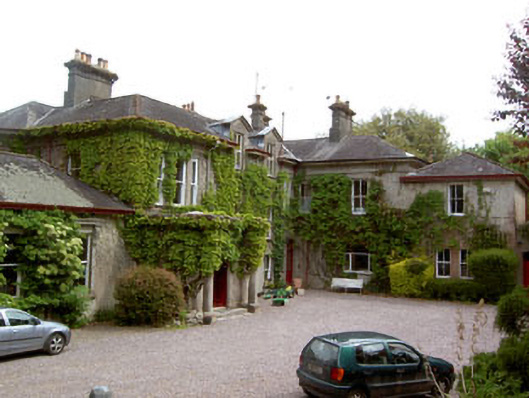
Detached irregular-plan two- and three-storey over-basement house, built c.1860, comprising four-bay south entrance front with projecting single-storey flat-roofed porch, with two-bay two-storey wing to south-east corner having single-bay addition and attached carriage arch to south gable. Two-bay single-storey former ballroom attached to west gable, entrance front. Full-height canted bays to north-east and north-west corners. Single-storey addition with curved end to east elevation. Hipped and pitched slate roofs with rendered chimneystacks, moulded eaves course and cast-iron rainwater goods. Gabled dormers to front elevation. Rendered walls. Square-headed openings having one-over-one and two-over-two timber sliding sash windows, in single, paired and tripartite arrangements. Timber panelled internal shutters. Timber panelled door having moulded render surround with vermiculated quoins, flanked by pair of Doric columns with entablature above. Polychrome tiles to porch interior. Garden pavillion to north-east. Farmyard complex to south-west. Remains of mill and lime kilns to site.
Built in the nineteenth century when the tower house to the north-west fell into ruin, this handsome house is thought to have been built by the O'Grady family. With remains of related structures including a mill, lime kilns and extensive outbuildings in the demesne, this house once formed the centre piece of a grand estate. The irregular plan and form are typical features of architectural fashions in the latter part of the nineteenth century. It retains much of its traditional fabric including timber sliding sash windows, decorative render details and internal features including timber panelled shutters and polychrome tiles.
From the Buildings of Ireland (National Inventory of Architectural Heritage) record 20909915
This does not grant access. Most recorded buildings are privately owned; view them only from public ground unless the owner allows entry.
Places near here
Photo credits
- National Inventory of Architectural Heritage
- Mike Searle, Geograph · CC BY-SA 2.0
- Jonathan Thacker, Geograph · CC BY-SA 2.0
- Hywel Williams, Geograph · CC BY-SA 2.0
- Honourablemencandiffer, Wikimedia Commons · Public domain
- Garry Dickinson, Geograph · CC BY-SA 2.0
- Jonathan Thacker, Geograph · Creative Commons Attribution-ShareAlike 2.0
Castle (in Ruins)Castle, tower house · 384 ydCoolmore WoodWood · 662 yd vent pipe1122 ydCoolmore HouseCountry house · 1552 ydWilliam Warren Baldwin plaqueMemorial · 1.5 miCurraghbinny WoodsForest · 1.6 miCrosshaven Tourist OfficeVisitor information · 1.6 miThe Giant's GraveMonument · 1.7 miCastle (in Ruins)Castle, tower house · 1.8 miMyrtleville BeachBeach / strand · 2.1 miMartello Tower2.2 miGrave YardGraveyard · 2.6 mi
 vent pipe1122 yd
 Coolmore HouseCountry house · 1552 ydWilliam Warren Baldwin plaqueMemorial · 1.5 mi
 Curraghbinny WoodsForest · 1.6 miCrosshaven Tourist OfficeVisitor information · 1.6 miThe Giant's GraveMonument · 1.7 mi
 Castle (in Ruins)Castle, tower house · 1.8 mi
 Myrtleville BeachBeach / strand · 2.1 mi
 Martello Tower2.2 mi
 Grave YardGraveyard · 2.6 mi
More historic places in County Cork · All of County Cork
What do you know about this place?