What is recorded here
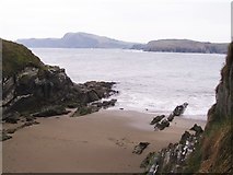
Hut site in Toehead is a hut site in County Cork, Ireland.
From the National Monuments Service (Archaeological Survey of Ireland) record CO151-063
The monument record does not grant public access. Check the route and ask the landowner before entering private land.
- What survives
- Recorded monument
Places near here
Photo credits
- Mac McCarron, Geograph · CC BY-SA 2.0
- Gordon Hatton, Geograph · CC BY-SA 2.0
Faill ChúCliff · 273 ydSliabh RiachMountain / peak · 473 ydCuasínBeach / strand · 523 ydDúinín Dhiarmuid MhóirArchaeological place · 742 ydTobar a' GhrafínSpring · 760 ydBawn in ToeheadBawn · 782 ydFaill a' chipínCliff · 828 ydSt Bartholomews WellHoly well · 984 ydCarraig a' RinceMountain / peak · 990 ydWild Atlantic Way:Toe Head BayVisitor information · 1157 yd Drishane IslandIslet · 1.6 miSandy CoveBeach / strand · 2.5 mi
 Drishane IslandIslet · 1.6 mi
 Sandy CoveBeach / strand · 2.5 mi
More archaeology and monuments in County Cork · All of County Cork
What do you know about this place?