What is recorded here
Subrectangular area projecting S into Atlantic; connected to mainland by narrow neck with V-shaped profile. Excavations by O'Kelly (1952, 35-54) showed that fosse of early defences (CO151-040---) re-cut in late medieval times when headland re-fortified. At neck stone causeway constructed on landward side of fosse; according to O'Kelly wooden drawbridge linked causeway to interior. Along edge of promontory sections of curtain wall survived, particularly to N, with opening corresponding to causeway. On S side of enclosure O'Kelly uncovered lower courses of rectangular structure (min. Wth 16ft; L 33ft) missing S end due to erosion. House had internal partition wall with smaller room used as kitchen with remains of 'hearth or wall-oven' in one corner. Overlying floor of house charred remains of wooden roof timbers and slates showing house destroyed by fire. Associated with occupation of house pottery of period 1550-1650, also lead ball bullets of about 1650. Many of the coastal promontory forts along the West Cork coastline were re-fortified in this period with tower-house and bawn enclosures (eg Dundeady CO144-039003-; Downeen CO143-069002-).
Subrectangular area projecting S into Atlantic; connected to mainland by narrow neck with V-shaped profile. Excavations by O'Kelly (1952, 35-54) showed that fosse of early defences (CO151-040---) re-cut in late medieval times when headland re-fortified. At neck stone causeway constructed on landward side of fosse; according to O'Kelly wooden drawbridge linked causeway to interior. Along edge of promontory…
From the National Monuments Service (Archaeological Survey of Ireland) record CO151-053001
The monument record does not grant public access. Check the route and ask the landowner before entering private land.
- What survives
- Recorded monument
Places near here
Dúinín Dhiarmuid MhóirArchaeological place · 40 ydFaill a' chipínCliff · 46 ydTrá LeathannBeach / strand · 92 ydSteillthúnHeadland · 230 ydSliabh RiachMountain / peak · 331 ydTobar a' GhrafínSpring · 424 ydCarraig a' RinceMountain / peak · 689 ydHut site in ToeheadHut site · 782 ydWild Atlantic Way:Toe Head BayVisitor information · 1570 ydWild Atlantic Way:Toe HeadVisitor information · 1.0 mi Drishane IslandIslet · 2.0 miSandy CoveBeach / strand · 2.3 mi
 Drishane IslandIslet · 2.0 mi
 Sandy CoveBeach / strand · 2.3 mi
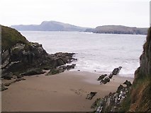
Pictures: Mac McCarron, Geograph · CC BY-SA 2.0; Gordon Hatton, Geograph · CC BY-SA 2.0
More castles and forts in County Cork · All of County Cork
What do you know about this place?