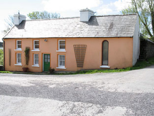
What is recorded here
Detached three-bay two-storey house, built c.1840, with altered double-height block to north-west. Pitched slate roof with rendered chimneystacks and cast-iron and uPVC rainwater goods. Painted rendered walls. Square-headed openings with one-over-one timber sliding sash windows with painted stone sills. Pointed arch…
Read the whole record
From the Buildings of Ireland (National Inventory of Architectural Heritage) record 20914806
Places near here
Picture notes
- National Inventory of Architectural Heritage
- Computer-made picture. It does not show this monument.
- Richard Webb, Geograph · CC BY-SA 2.0
- Richard Webb, Wikimedia Commons · CC BY-SA 2.0
- Computer-made picture. It does not show this playground.
- Mick Garratt, Geograph · CC BY-SA 2.0
- Kondephy, Wikimedia Commons · CC BY-SA 4.0
- Gordon Hatton, Geograph · CC BY-SA 2.0
- Graham Horn, Geograph · CC BY-SA 2.0
- Martin Southwood, Geograph · CC BY-SA 2.0
 Lowertown HouseHouse · 521 yd
Explorer Tom Lowertown House has a symmetrical façade with central chimneystacks that are basically twins. It retains many original features, so it’s got good genes. Best seen when you’re not distracted by the fact that it’s just standing there doing nothing wrong.
 RalahidFairy fort / earthen ringfort · 644 ydTom: I’m here to help · Computer-made picture. It does not show this monument.
Explorer Tom Ralahid in Lowertown is a proper ringfort with a three-metre high earthen bank. It sits on an east-facing slope with a causeway to the entrance, so if you can get past the landowner, it’s quite the imposing little dirt castle.
 Fairy fort / earthen ringfort in GubbeenFairy fort / earthen ringfort · 800 ydTom: I’m here to help · Computer-made picture. It does not show this monument.
Explorer Tom Fairy fort / earthen ringfort in Gubbeen has got cultivation ridges running through it like it’s a zebra crossing for tractors. I bet it orders a massive portion of chips just to look bigger. Bring your own legend, because mine ran out of fuel at the pub.
 Sea FortCountry house · 941 yd
Explorer Tom Sea Fort in Croagh is sitting pretty overlooking a tidal channel. It’s a late eighteenth-century gem that looks like it belongs in a different century entirely. The owners probably made their fortune in shipping, so imagine the gossip flying around here back in the day!
 Coney IslandIslet · 1.2 mi
Explorer Tom Coney Island has caught my eye in County Cork. I bet a islet with a name like that could keep me talking all afternoon; I'm already inventing a daft little scene for it, and I'll stop before it turns into history.
 Long IslandIsland · 1.9 mi
Explorer Tom Long Island has caught my eye in County Cork. I bet a island with a name like that could keep me talking all afternoon; I'm already inventing a daft little scene for it, and I'll stop before it turns into history.
 Children's playground2.0 miTom: I’m here to help · Computer-made picture. It does not show this playground.
Explorer Tom Children's playground has caught my eye in County Cork. I bet a children's playground with a name like that could keep me talking all afternoon; I'm already inventing a daft little scene for it, and I'll stop before it turns into history.
 AltarViewpoint · 2.4 mi
Explorer Tom Altar has caught my eye in County Cork. I bet a viewpoint with a name like that could keep me talking all afternoon; I'm already inventing a daft little scene for it, and I'll stop before it turns into history.
 Mount GabrielMountain / peak · 3.4 mi
Explorer Tom Mount Gabriel has caught my eye in County Cork. I bet a mountain / peak with a name like that could keep me talking all afternoon; I'm already inventing a daft little scene for it, and I'll stop before it turns into history.
 Mount Gabriel View Point toward SouthViewpoint · 3.4 mi
Explorer Tom Mount Gabriel View Point toward South has caught my eye in County Cork. I bet a viewpoint with a name like that could keep me talking all afternoon; I'm already inventing a daft little scene for it, and I'll stop before it turns into history.
 Dunmanus Castle (in Ruins)Castle, tower house · 3.6 mi
Explorer Tom Dunmanus Castle is a proper four-storey beauty with a five-storey corner tower that looks like it’s shouting at the bay. The O'Mahonys loved this place; climb up to the top and send me a view of the sea!
 Castle (in Ruins)Castle, tower house · 3.8 mi
Explorer Tom Castle on Castle Island in Roaringwater Bay is fragmentary and sits on a promontory. Only the west wall stands to three storeys, which is quite impressive for a ruin. It belonged to the O Mahony clan, so it has history!
More historic places in County Cork · All of County Cork

What do you know about this place?Tap to add a comment or ask a question