
Places near here
Photo credits
- National Inventory of Architectural Heritage
- Ericpol ( talk ), Wikimedia Commons · CC BY-SA 3.0
- Jeff Buck, Geograph · CC BY-SA 2.0
- Ernest Riordan, Geograph · CC BY-SA 2.0
- Towel401, Wikimedia Commons · CC BY-SA 4.0
- Adriaen van Diest, Wikimedia Commons · Public domain
- Gordon Hatton, Geograph · CC BY-SA 2.0
- Colin Park, Geograph · CC BY-SA 2.0
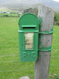 post box221 yd
Explorer Tom Post box in Boher has got a P&T emblem on the cast-iron box from around 1930. It’s a reminder of when Ireland changed up its post boxes. The royal cipher is gone now. Look at that display panel, it’s neat!
Mass-rock in ArdaganniveMass-rock · 785 ydExplorer Tom Mass-rock in Ardagannive sits in scrubland like a lazy boulder having a nap. People used to hold services there, but now it’s just judging your hiking gear. Linger, it’s not going anywhere and neither should you.
Enclosure in Rossmackowen CommonsEnclosure · 1101 ydExplorer Tom Enclosure in Rossmackowen Commons in County Cork is playing hide-and-seek on Hungry Hill. It’s a tiny stone circle that tried to compensate for the slope, probably just like your posture after three pints. Find the wonkiest bit and send it to your group chat.
 Hungry HillMountain / peak · 1.5 mi
Explorer Tom Hungry Hill got its name from a priest who lost a bet and had to eat his hat right there on top. He never quite recovered from the indignity, so now he haunts the lower slopes looking for snacks. It’s a bit of a spooky story, but mostly just about bad luck and hunger.
 battery1.5 mi
Explorer Tom Battery in Ardaragh East on Bere Island has four gun emplacements that are definitely ready for a zombie apocalypse. It’s discreet enough to hide from your in-laws if they visit. Wait for the all-clear before you nap.
TrawnablahaBeach / strand · 1.8 miExplorer Tom Trawnablaha in County Cork would say 'I bring stability and excellent sand quality' in a job interview. It would also mention its extensive network of local connections and how good it is at absorbing foot traffic. The interviewer would be terrified by its confidence but impressed by its sheer, unapologetic existence right there on the map. Bring the dog, it'll have opinions.
 Mare's Tail WaterfallViewpoint · 2.1 mi
Explorer Tom Mare's Tail Waterfall in County Cork has a bird that refuses to leave no matter how wet it gets. It sits right at the top, looking like it’s judging your swimming ability. The water is very loud and slightly dramatic about its own height. Bring a coin for luck and keep it in your pocket.
 KnocknagreeMountain / peak · 2.7 mi
Explorer Tom Knocknagree is claimed to have been invented by a local man who just pointed at it one day. He says he named it himself, which is convenient since nobody else can prove otherwise anyway. Whisper a secret at it, it's kept worse.
 Bere IslandIsland · 3.5 mi
Explorer Tom Bere Island has a retirement plan that involves doing absolutely nothing except looking majestic while the tourists try to figure out how to get back across the water. It’s living its best life, knowing it has no bills or deadlines. Great spot to propose. Or at least to propose lunch.
 Battle of Bantry BayMajor battlefield · 3.6 mi
Explorer Tom Battle of Bantry Bay in County Cork is where a French admiral got his arse kicked by the weather before he even saw an English ship. Ideal for a moody photo you'll pretend wasn't posed.
 Dinish IslandIslet · 4.6 mi
Explorer Tom Dinish Island in County Cork would bring a bottle of wine and a very bad playlist to any party it attended. It doesn’t care if you dance or sit in the corner, as long as you acknowledge its existence before leaving. Mind the nettles, they're the real guards here.
 Finn McCool's SeatViewpoint · 6.1 mi
Explorer Tom Finn McCool's Seat started when two lads bet in the pub that they could sit on a rock and look like giants, and one actually did it. Now everyone pretends the legend is real, but really it’s just a big stone with a personality crisis. Pretend it's yours and plan the housewarming.
More historic places in County Cork · All of County Cork

What do you know about this place?Tap to add a comment or ask a question