DDiscover AloneMapAbout

House in Drumboe Upper

House
House in Drumboe Upper
Photo: National Inventory of Architectural Heritage · Report the wrong picture

This does not grant access. Most recorded buildings are privately owned; view them only from public ground unless the owner allows entry.

Recorded change of use
Originally house; recorded by the architectural inventory as outbuilding
What do you know about this place?Tap to add a comment or ask a question

What you write will be public.

What is recorded here

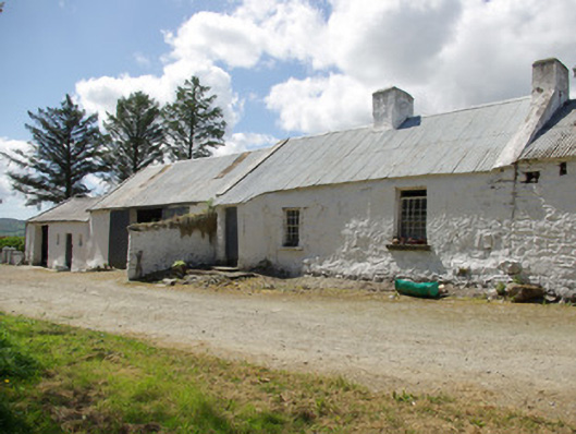
Detached three-bay single-storey vernacular house, built c. 1780, having canted windbreak porch to the south-west end of the front elevation (south-east), bed out-shot to the rear (north-west), single-bay two-bay byre\outbuilding attached to the north-east gable end with water trough projection, and with two…

Read the whole record
Detached three-bay single-storey vernacular house, built c. 1780, having canted windbreak porch to the south-west end of the front elevation (south-east), bed out-shot to the rear (north-west), single-bay two-bay byre\outbuilding attached to the north-east gable end with water trough projection, and with two single-storey outbuildings to the south-west. Section of rubble stone walling adjacent to porch. House now out of use. Pitched corrugated-metal roof with raised whitewashed rendered verges to the gable ends (rubble stone to the north-east gable end), some surviving sections of cast-iron rainwater goods, and with two rendered chimneystacks (one to the north-west gable end and one to the centre. Formerly thatched. Whitewashed rubble stone walls. Irregularly-spaced square-headed window openings with cut stone sills and with eight-over-eight and six-over-six pane timber sliding sash windows. Square-headed doorway to front face of canted porch having plinth blocks and battened timber door. Attached two-bay single-storey outbuilding to the north-east having pitched corrugated-metal roof, rubble stone walls, square-headed doorway with battened timber door, and with square-headed carriage-arch having corrugated-metal gate. Attached single-bay single-storey outbuilding to the south-west gable end having pitched corrugated-metal roof, rendered rubble stone walls, and square-headed carriage-arch with sliding corrugated-metal double gates; attached four-bay single-storey outbuilding to the extreme south-west having pitched natural slate roof, cast-iron rainwater goods, rubble stone walls, and square-headed window and door openings with timber fittings. Set back from road in own grounds with yard to the front (south-east) and with later three-bay two-storey house adjacent to the south. Located in the rural countryside to the north-west of Stranorlar. Wrought-iron flat-bar gates to site.
Although no longer in use as a dwelling, this appealing and relatively intact example of a vernacular house retains its early form and character, and is an appealing feature in the rural landscape to the north-west of Stranorlar. Its integrity is enhanced by the retention of much of its salient fabric including timber sliding sash windows. These windows are unusually large for a vernacular dwelling, and help create a distinctive composition of some rustic appeal. Modest in scale, it exhibits the simple and functional form of vernacular building in Ireland. It retains some characteristic features of the vernacular tradition to the area, including a bed outshot to the rear, while the windbreak porch, another characteristic feature of vernacular buildings in Donegal, has a mildly canted-plan that is a feature of a number of buildings surviving in the rural landscape in that Stranorlar and Convoy areas. The corrugated-metal roof to the dwelling suggests that this building was formerly thatched, an impression that is reinforced by the shape of the raised verge to the north-east gable end and by the evidence of a more steeply pitched roof fossilised in the chimneystacks to the same gable. The attached rubble stone outbuildings to either gable end add considerably to the context and setting, and help to create a long low vernacular composition of some rustic and visual appeal with a stepped and varied roofline. These features hint that this building may be of considerable antiquity as a possible development of the ‘long-house’ or ‘byre-dwelling’ that was common in Donegal during the eighteenth century. The attached outbuilding to the south-west gable end may have been a former dwelling, later converted to an outbuilding. The position of the chimneystacks is unusual for a vernacular dwelling in Donegal, which are almost universally to be found at the gable ends or two the original gable ends of an elongated building (direct-entry plan). This house represents a fine surviving example of a once ubiquitous building type in the rural Irish countryside, and is a valuable addition to the vernacular heritage of County Donegal.

From the Buildings of Ireland (National Inventory of Architectural Heritage) record 40907834

Places near here

Picture notes
  • Computer-made picture. It does not show this monument.
  • National Inventory of Architectural Heritage
  • Willie Duffin, Geograph · CC BY-SA 2.0
  • Computer-made picture. It does not show this walking route.
  • Kenneth Allen, Geograph · CC BY-SA 2.0
  • Computer-made picture. It does not show this playground.
  • Computer-made picture. It does not show this mountain top.
Fairy fort / ringfort in BallynaglackFairy fort / ringfort · 796 ydComputer-made picture

Explorer Tom Fairy fort / ringfort in Ballynaglack is just a curving field fence and a name called 'Ganges' Fort'. The actual ring has vanished, leaving only the sharp drop to the west and some local gossip. It’s not much to see, but standing there on that edge with wide views makes you wonder if the fairies really lived here.

Fairy fort / earthen ringfort in Backlees,dunwileyFairy fort / earthen ringfort · 1009 ydComputer-made picture

Explorer Tom Fairy fort / earthen ringfort in Backlees, Dunwiley had an inner bank, a lower terrace, a ditch and another bank. The survey described breaks and a causeway on the eastern side, where the hill's slope was gentler. This was not just one circle drawn in dirt; its layers make a small map of defence.
Dunwiley HouseHouse · 1036 yd

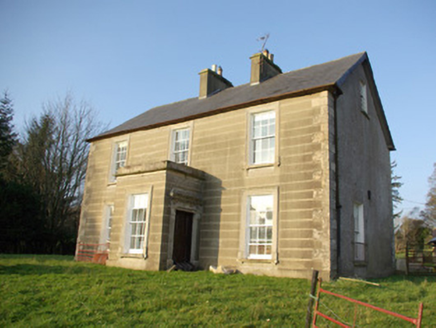
Explorer Tom Dunwiley House is a mid-nineteenth-century beauty with elaborate Doric surrounds and natural slate roofs. It’s well-detailed and retains its original character, so photograph that render architrave work if you can spot it from the road!
The ManseManse · 1177 yd

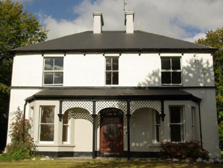
Explorer Tom The Manse in Stranorlar is showing off those fancy cast-iron columns on the porch like they’re royal regalia. It’s got that late Victorian vibe down to a tee, mate. Try not to scratch the decorative capitals, yeah?

Drumboe WoodForest recreation place · 1343 yd

Explorer Tom Drumboe Wood is a riverside walk with harder history nearby: a castle once guarded the River Finn ford, and a memorial recalls four men executed here in 1923. I would give that stone a quiet moment.

Drumboe - Loop trailOfficial walking route · 1355 ydComputer-made picture

Explorer Tom Drumboe - Loop trail is barely even a loop; it’s just a very short walk with commitment issues. Nine hundred metres of pretending you’re on an expedition. Pack a picnic and an excuse for why you stopped halfway through.

Drumboe - Multi-AccessOfficial walking route · 1355 ydComputer-made picture

Explorer Tom Drumboe - Multi-Access sounds fancy but it’s really just a one-kilometre shuffle with extra steps. You can enter from anywhere, which is great if you get lost immediately. Bring curiosity, leave with a better story than mine, or at least a sore foot.

McGuigan's BarPub · 1451 yd

Explorer Tom McGuigan's Bar is out in County Donegal without a specific town listed, so it might be a bit of a hidden gem for those who know where to look. Check if it's easy to find or requires asking three separate locals for directions first.

The Rosses BarPub · 1503 yd

Explorer Tom The Rosses Bar is in Stranorlar, which sounds like it caters to people who know exactly where they are and don't need directions. Ask if the name refers to a specific local area or just general pride.

Children's playground1713 ydComputer-made picture

Explorer Tom Children's playground in County Donegal might be haunted by a very bored imaginary friend named Kevin. He’s been waiting here since the last recess bell rang. Ten minutes here and you'll have a yarn for the pub.

Edenmore HillMountain / peak · 2.0 miComputer-made picture

Explorer Tom Edenmore Hill sits in County Donegal with its access details currently unknown. The name sounds like it’s trying to explain itself, but without a single recorded path, it might as well be hiding behind an imaginary hedge.

Thonevancil HillMountain / peak · 3.2 miComputer-made picture

Explorer Tom Thonevancil Hill has got ancient vibes that I am absolutely making up right now. It looks older than my excuses for being late. Go with someone who loves old stuff and watch them melt into the ground.

More historic places in County Donegal · All of County Donegal

Add to this placeAdd a picture Add a detailed tip Add a story

Explore the map1,093,392 places to discover

Next place · or swipeFairy fort / ringfort in Ballynaglack