DDiscover AloneMapAbout

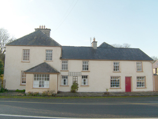
House in Creeslough

House
House in Creeslough
Photo: National Inventory of Architectural Heritage · Report the wrong picture

What is recorded here

Attached pair of two- and three-bay two-storey houses, built c. 1840, having two-storey addition, c. 1860, attached to the north-west, and with taller two-bay two-story house (three-bay two-storey elevation to the south-east), added c. 1870, attached to the south-east having projecting single-storey single-bay…

Read the whole record
Attached pair of two- and three-bay two-storey houses, built c. 1840, having two-storey addition, c. 1860, attached to the north-west, and with taller two-bay two-story house (three-bay two-storey elevation to the south-east), added c. 1870, attached to the south-east having projecting single-storey single-bay entrance porch attached to the north-east elevation. Possibly incorporating earlier building to site, c. 1820, Formerly probably in use as a hotel\bar and or retail outlet. Single-storey extension to the west side of house to the south-east end. Pitched natural slate roof to houses to the north-west having rendered chimney with flat coping to the centre with terracotta pots over, projecting eaves course, and with cast-iron rainwater goods. Hipped slate roof to taller house to south-east having central rendered chimneystack with flat coping and terracotta pots over, and with cast-iron rainwater goods. Hipped natural slate roof to entrance porch. Hipped slate roof to rear extension with timber eaves course, and cast-iron rainwater goods. Roughcast rendered walls with raised smooth rendered plinth course to two two-storey houses to the north-west. Rubble stone walls to rear extension to the north-west. Square-headed window openings with smooth rendered reveals, some surviving stone sills, and with six-over-six pane timber sliding sash windows to block to the south-east and replacement timber casement windows elsewhere. Square-headed doorway to the north-west face of porch having replacement glazed timber door. Square-headed doorway to the centre of three-bay two-storey house to the north-west end having smooth rendered reveals, and with battened timber door. Set slightly back from road in the rural countryside to the north-west of Creeslough with raised flagstone plinth to the front (north-east). Garden to the south having section of rubble stone boundary wall to the road-frontage to the east and north-east; wrought-iron gate to garden from the north-east corner. Yard to the north-west entered through gateway adjacent to road having a pair of smooth rendered gate piers with wrought-iron flat bar gates; section of rendered rubble stone boundary wall to the north-west side of pair to the north. Detached seven-bay two-storey outbuilding, built c. 1860, to the north side of yard to the north-west having pitched purple natural slate roof with exposed rafter ends and cast-iron rooflights, partially roughcast rendered rubble stone walls, square-headed window openings (some with red brick surrounds) with remains of timber fittings, segmental-headed carriage-arch, and square-headed doorways and loading bays some with remains of timber fittings.
This interesting and attractive group of two-storey buildings, probably originally dating to the mid-to-late nineteenth century, retains much of its early form and character despite some modern alterations. Its visual appeal and integrity are enhanced by the retention of salient fabric such as the pitched and hipped natural slate roofs, cast-iron rainwater goods, and the timber sliding sash windows to the block to the south-east end. The loss of the salient fabric elsewhere is regrettable but suitable replacements could easily be reinstalled. The blocks to the north-west end may incorporate fabric from an earlier building to site that was extant in c. 1834 (Ordnance Survey first edition six-inch map) but the form of the group suggests that it was built later. The two-storey houses to the north-west are characterised by low ceiling heights, especially when compared to the later block to the south-east. The scale of this building, and its location adjacent to a main road, suggests that it was probably formerly in use as a hotel and\or shop\bar. The substantial and robust two-storey rubble stone outbuilding to the north also survives in good condition and adds significantly to the site and context. The scale of this outbuilding also suggests that this was formerly in use as hotel etc. This building is an interesting feature along the roadscape to the north-west of Creeslough, and is an addition to the built heritage of the local area as one of the few traditional buildings that retains much of its early character. The rubble stone wall to the south-east, and the wrought-iron gates complete this composition.

From the Buildings of Ireland (National Inventory of Architectural Heritage) record 40813006

This does not grant access. Most recorded buildings are privately owned; view them only from public ground unless the owner allows entry.

What do you know about this place?Tap to add a comment or ask a question

What you write will be public.

Places near here

Photo credits
  • National Inventory of Architectural Heritage
  • Kenneth Allen, Geograph · CC BY-SA 2.0
  • Kenneth Allen, Wikimedia Commons · CC BY-SA 2.0
  • Ross, Wikimedia Commons · CC BY-SA 2.0
  • Original uploaded by Brendandh (Transfered by Lvova ), Wikimedia Commons · CC BY 2.5
  • Rossographer, Wikimedia Commons · CC BY-SA 2.0
  • Joseph Mischyshyn, Geograph · CC BY-SA 2.0
  • Vadim Manuylov, Wikimedia Commons · CC BY-SA 3.0
  • Rossographer, Geograph · CC BY-SA 2.0
  • C.B.Doak (user Zorba the Geek ), Wikimedia Commons · Public domain
bridge335 yd

Explorer Tom Bridge in Masiness ended up in the wrong place because someone misplaced it during the railway construction days, and it’s still confused about why it’s there now. It’s an elegant former railway bridge from 1947 that seems to be mourning its lost tracks. Give it a sympathetic look if you see it, but don’t let it tell you where it really belongs!
Faymore ViaductViaduct · 463 yd

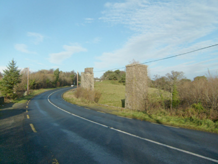
Explorer Tom Faymore Viaduct has squared and snecked stonework with drafted margins to its corners. Built around 1903, it looks like someone used a ruler on the river itself! I wonder if the trains ever complained about the strictness of those perfect stone edges?

Rose's BarPub · 995 yd

Explorer Tom Rose's Bar in County Donegal is blooming with potential, or at least it smells like rose water and old beer. Go there if you want to feel pretty and slightly dizzy. Take a breath of that air, it's older than your car.

Mcnulty's BarPub · 1047 yd

Explorer Tom McNulty’s Bar is likely full of people who think they’re great at darts but actually miss everything. Watch them fail, then laugh quietly so they don’t notice you doing it from across the room. Have a chat with it, nobody's watching.

Faymore DolmenNamed dolmen · 1.0 mi

Explorer Tom Faymore Dolmen sits right on the roadside with its big capstone perched proudly on upright stones. I can’t find an official number for it, but seeing that massive rock balanced there makes me wonder what story it’s keeping to itself.

Ards Forest ParkForest recreation place · 1.6 mi

Explorer Tom Ards Forest Park puts four ringfort remains, a holy well and a Mass rock among walks that also reach salt marsh and sand dunes. Ancient stones and sea air make a rather full day here.

Doe CastleCastle, tower house · 2.0 mi

Explorer Tom Doe Castle is a real legend, having sheltered survivors of the Spanish Armada way back in 1588. Perched on a promontory in Sheephaven Bay, it’s a dramatic spot where the sea protects three sides of this historic tower house.

Ballymore Lower Tomb near DunfanaghyMegalithic tomb · 2.2 mi

Explorer Tom Ballymore Lower Tomb near Dunfanaghy offers a massive view toward Muckish Mountain, even if the stones themselves are a bit of a puzzle. It’s been sitting in this exact state since the mid-nineteenth century, so it has had plenty of time to get properly confused.

Ards Friary Coastal LoopOfficial walking route · 2.8 mi

Explorer Tom Ards Friary Coastal Loop would bring a bottle of wine and a dramatic monologue about its own decay to any party it attended. It’s a loop that feels like it’s trying to tell you a secret but keeps forgetting the punchline mid-sentence. Visit, then text me what you think. I'll pretend to read it.

Monterey Cypress2.9 mi

Explorer Tom Monterey Cypress in County Donegal would have told Saint Patrick to go away because he was blocking the light and making too much noise about snakes. It’s got that old-tree wisdom where it knows better than to get involved in religious debates. Visit, then text me what you think. I'll pretend to read it.

Clonmass IslandIslet · 3.5 mi

Explorer Tom Clonmass Island in County Donegal was designed by a mother-in-law who wanted to make sure nobody could get comfortable there. It sits right next to Little Isle, acting like the strict older sister of the whole bay. Spot the oldest stone on the beach and give it a proper name.

MuckishMountain / peak · 3.6 mi

Explorer Tom Muckish means pig's back, and I promise the Donegal mountain is better company than an actual pig on a steep path. Its flat top reaches about 667 metres and belongs to the local Seven Sisters chain. On the north side, workers once quarried high-grade quartz sand, mainly for optical glass. Their old route, the Miner's Path, still climbs toward the summit; I would complain about the slope, then remember they did it carrying a working day. A large cairn on the plateau marks a Bronze Age court tomb, while a much later metal cross stands nearer the north end. Do not mistake one for the other just because the cloud has arrived. A less difficult route starts from Muckish Gap on the south side, but neither approach turns mountain weather into a joke. Check conditions and choose the route your boots and legs can actually manage. I'll race you to the view only after we agree walking counts as racing.

More historic places in County Donegal · All of County Donegal

Add to this placeAdd a picture Add a detailed tip Add a story

Explore the map1,093,392 places to discover

Next place · or swipebridge