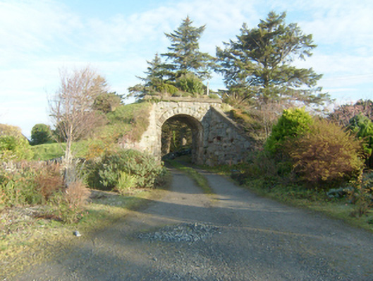
What is recorded here
Single-arch former railway accommodation bridge, built c. 1903, carrying the former Letterkenny to Burtonport section of the Derry (Middle Quay) to Burtonport railway line over small private laneway. Railway lines now out of use with tracks removed (c. 1947). Segmental-headed arch having squared mildly rock-faced…
Read the whole record
From the Buildings of Ireland (National Inventory of Architectural Heritage) record 40813005
Places near here
Photo credits
- National Inventory of Architectural Heritage
- Kenneth Allen, Geograph · CC BY-SA 2.0
- Kenneth Allen, Wikimedia Commons · CC BY-SA 2.0
- Ross, Wikimedia Commons · CC BY-SA 2.0
- Rossographer, Wikimedia Commons · CC BY-SA 2.0
- Original uploaded by Brendandh (Transfered by Lvova ), Wikimedia Commons · CC BY 2.5
- Joseph Mischyshyn, Geograph · CC BY-SA 2.0
- Vadim Manuylov, Wikimedia Commons · CC BY-SA 3.0
- Rossographer, Geograph · CC BY-SA 2.0
- C.B.Doak (user Zorba the Geek ), Wikimedia Commons · Public domain
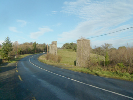 Faymore ViaductViaduct · 132 yd
Explorer Tom Faymore Viaduct has squared and snecked stonework with drafted margins to its corners. Built around 1903, it looks like someone used a ruler on the river itself! I wonder if the trains ever complained about the strictness of those perfect stone edges?
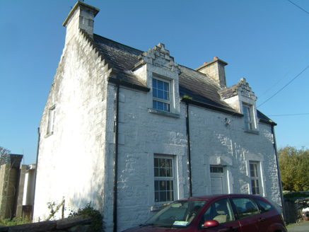 Ards FarmWorker's house · 971 yd
Explorer Tom Ards Farm was built around 1890 with two crow-stepped dormers that look like tiny staircases climbing the roof. This former worker's house borrowed a little Scottish castle style; even its upstairs windows dressed for the occasion.
 Rose's BarPub · 1326 yd
Explorer Tom Rose's Bar in County Donegal is blooming with potential, or at least it smells like rose water and old beer. Go there if you want to feel pretty and slightly dizzy.
 Mcnulty's BarPub · 1378 yd
Explorer Tom McNulty’s Bar is likely full of people who think they’re great at darts. Watch them miss, then laugh quietly so they don’t notice you laughing.
 Faymore DolmenNamed dolmen · 1642 yd
Explorer Tom Faymore Dolmen sits right on the roadside with its big capstone perched proudly on upright stones. I can’t find an official number for it, but seeing that massive rock balanced there makes me wonder what story it’s keeping to itself.
 Ards Forest ParkForest recreation place · 1.4 mi
Explorer Tom Ards Forest Park puts four ringfort remains, a holy well and a Mass rock among walks that also reach salt marsh and sand dunes. Ancient stones and sea air make a rather full day here.
 Ballymore Lower Tomb near DunfanaghyMegalithic tomb · 2.0 mi
Explorer Tom Ballymore Lower Tomb near Dunfanaghy offers a massive view toward Muckish Mountain, even if the stones themselves are a bit of a puzzle. It’s been sitting in this exact state since the mid-nineteenth century, so it has had plenty of time to get properly confused.
 Doe CastleCastle, tower house · 2.0 mi
Explorer Tom Doe Castle is a real legend, having sheltered survivors of the Spanish Armada way back in 1588. Perched on a promontory in Sheephaven Bay, it’s a dramatic spot where the sea protects three sides of this historic tower house.
 Ards Friary Coastal LoopOfficial walking route · 2.7 mi
Explorer Tom We can drive clockwise to enter this friary grounds. Let's take this moderate coastal loop and soak up those historic, salt-air views.
 Monterey Cypress2.8 mi
Explorer Tom Another charming Monterey Cypress in Donegal awaits, so remember to check if permission is needed first.
 Clonmass IslandIslet · 3.3 mi
Explorer Tom Clonmass Island sits near Little Isle at the north of Clonmass Bay, a place where accurate maps are essential for finding your way.
 MuckishMountain / peak · 3.6 mi
Explorer Tom Well, look at that, Muckish is standing tall in County Donegal, and I heard it looks particularly dramatic from Horn Head. It’s a proper mountain with a bit of mystery to it, so let’s keep our eyes peeled for any hidden paths as we get closer.
More historic places in County Donegal · All of County Donegal

What do you know about this place?Tap to add a comment or ask a question