
Places near here
Photo credits
- National Inventory of Architectural Heritage
- Rick Crowley, Geograph · CC BY-SA 2.0
- Andy Beecroft, Geograph · CC BY-SA 2.0
- Einaz80, Wikimedia Commons · CC BY-SA 4.0
- The Speckled Bird, Wikimedia Commons · CC BY-SA 4.0
- Marathon, Wikimedia Commons · CC BY-SA 2.0
- David Dixon, Geograph · CC BY-SA 2.0
- Andy Beecroft, Wikimedia Commons · CC BY-SA 2.0
 water pump924 yd
Explorer Tom Water pump in Bawnavota is a cow-tail cast-iron beauty, looking a bit inconspicuous but really feeling very important about its mass-produced status. It’d tell the plastic replacement that it’s got heritage. Twinkles on the handle, mate.
 Charles FortBarracks · 1676 yd
Explorer Tom Charles Fort in Forthill has soldier's quarters built right into the ramparts. It’s a star-shaped fort, which is cool if you like geometry lessons. The red brick arches look sturdy enough to hold a tank!
Graveyard in ArdbrackGraveyard · 1.2 miExplorer Tom The Graveyard in Ardbrack has been in use since the 1750s, so it’s older than most of us and probably wiser. It’s rectangular, which is nice and organized, unlike my life. If it taught history, it would start with 'Death is inevitable, but good shoes help.' Bring a map, get lost anyway, that's the fun.
 Kinsale HarbourBay · 1.3 mi
Explorer Tom Kinsale Harbour is hiding a secret message in its stones, allegedly written by a fisherman who got fed up of waiting for the tide to turn. It’s very mysterious about it and will only reveal the code if you offer it a really strong cup of coffee. Look up, the best bit is always higher than you think.
 Old FortBastioned fort · 1.6 mi
Explorer Tom Old Fort in Kinsale would post a selfie looking incredibly brooding and caption it 'Vibes only' to annoy all its followers from centuries ago. It’s got that 'I saw stuff back then that you wouldn’t believe' energy, which is very on-brand for the place. Perfect detour when the satnav has a meltdown.
 James' FortArchaeological place · 1.6 mi
Explorer Tom James Fort sits across Kinsale Harbour from Charles Fort, and I would pay to hear the two of them argue over who had the better side. Work began in 1602 after the Siege of Kinsale, replacing earlier defences on Castlepark peninsula. The five-sided fort watched ships coming in along the Bandon estuary. When Charles Fort rose later on the opposite shore, James earned the nickname old fort, which seems cheeky given it had barely settled in. I would have objected on its behalf, then lost my place on the map. The protected ruins are open to visitors under current public arrangements; check access and mind rough ground, drops and weather. Walk around the shape before staring across the water. The harbour makes the whole defensive plan clearer than any diagram I could draw in the sand.
Dock BeachBeach / strand · 1.6 miExplorer Tom Dock Beach would say to the place that replaced it, ‘at least I had the decency to be called Dock Beach, not whatever nonsense they’ve named it now,’ which shows its true colours. It’s got that industrial edge mixed with natural beauty, so you get a bit of both worlds without having to choose between them. Ideal place to rehearse an excuse for being late.
 Scilly ParkGarden · 1.8 mi
Explorer Tom Scilly Park in County Cork claims it’s older than the concept of parking itself. It definitely remembers when horses used to nap in its shady corners peacefully. Bring a map, get lost anyway, that's the fun.
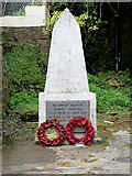 World War I MemorialMemorial · 1.8 mi
Explorer Tom World War I Memorial is locked in a silent, dramatic standoff with the nearest tree, which has grown so thick that it’s basically blocking the memorial’s view of the sky. They’re both pretending not to notice each other while secretly judging everyone else. Bring a map, get lost anyway, that's the fun.
Kinure Castle (Site of)Castle, unclassified · 1.9 miExplorer Tom Kinure Castle was built by the Roche family way back in 1576. It’s sitting on a slope overlooking Ballinclashet creek with absolutely nothing left to see. Just a spot where history used to hang out before vanishing.
Great Sovereign IslandIsland · 1.9 miExplorer Tom Great Sovereign Island in County Cork thinks it’s royalty but got stuck in the wrong postcode. It probably wandered over from a different coast entirely and forgot to turn back. Sit on a wall near it and pretend you're in a painting.
 Sandy Cove IslandIslet · 2.3 mi
Explorer Tom Sandy Cove Island has a local who swears he invented the whole place with a shovel and some sand. It's free, it's odd, what more do you want from a day out in the wilds of County Cork today?
More historic places in County Cork · All of County Cork

What do you know about this place?Tap to add a comment or ask a question