DDiscover AloneMapAbout

House in Callancor

House
House in Callancor
Photo: National Inventory of Architectural Heritage · Report the wrong picture

This does not grant access. Most recorded buildings are privately owned; view them only from public ground unless the owner allows entry.

Recorded change of use
Originally house; recorded by the architectural inventory as outbuilding
What do you know about this place?Tap to add a comment or ask a question

What you write will be public.

What is recorded here

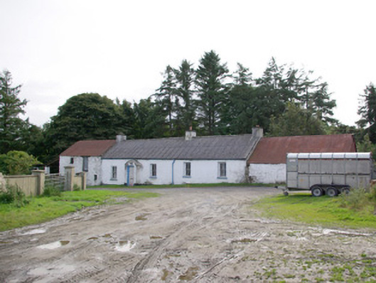
Detached five-bay single-and two-storey vernacular house, built c. 1800 and extended c. 1860, having mildly canted single-bay windbreak porch with rounded roof to the centre of the original dwelling, bed outshot to the rear elevation (south-west), single-bay single-storey outbuilding attached to the north-west gable…

Read the whole record
Detached five-bay single-and two-storey vernacular house, built c. 1800 and extended c. 1860, having mildly canted single-bay windbreak porch with rounded roof to the centre of the original dwelling, bed outshot to the rear elevation (south-west), single-bay single-storey outbuilding attached to the north-west gable end, and with two-bay two-storey outbuilding and possible former mill attached to the south-east gable end. Now disused. Pitched corrugated-cement roof with three rendered chimneystacks (one to either end of original dwelling with one to the north-west gable end), raised rendered verge to the north-west gable end, and with cast-iron rainwater goods. Limewashed smooth rendered with cement rendered plinth. Square-headed window openings with smooth rendered reveals, cut stone sills, and two-over-two pane timber sliding sash windows. Square-headed doorway to the front face of porch (north-east) having replacement timber panelled door and cut stone step/threshold. Attached two-bay two-storey outbuilding to the south-east having pitched corrugated-metal roof with projecting stone eaves course, limewashed rubble stone walls, square-headed window openings (fittings now gone), and square-headed door openings with replacement metal doors. Single-bay single-storey outbuilding attached to the north-west gable end having corrugated-metal roof, rubble stone walls, and square-headed openings with fittings now gone. Set back from road in own grounds to the west of Convoy, and adjacent to the north bank of the River Deele. Former millrace to the north of site; modern farm buildings to site.
Although no longer in use as a dwelling, this appealing and relatively intact example of a vernacular house retains its early form and character, and is an appealing feature in the scenic rural landscape to the west of Convoy. Its integrity is enhanced by the retention of much of its salient fabric including timber sliding sash windows. Modest in scale, it exhibits the simple and functional form of vernacular building in Ireland. It retains some characteristic features of the vernacular tradition to the area, including a bed outshot to the rear, while the windbreak porch, another characteristic feature of vernacular buildings in Donegal, has a mildly canted-plan that is a feature of a number of buildings surviving in the rural landscape to the west of Convoy. The corrugated-cement roof to the dwelling indicates that this building was formerly thatched, while the cast-iron rainwater goods suggest that the roof was replaced at a relatively early date, perhaps c. 1950. The low elongated form of this building suggests that it was extended along its length) to the north-west) at some stage, which is a feature of extended vernacular house, or that it was originally two semi-detached houses that were later amalgamated. The form of this building, having chimneystacks to the gable ends and a central doorway to the original building, suggests that this building is of the ‘direct entry’ type that is characteristic of the vernacular tradition in north-west Ireland. The attached rubble stone outbuildings to site add considerably to the context and setting, and help to create a long low vernacular composition of some rustic and visual appeal. The two-storey outbuilding to the south-west is an interesting structure in its own right, its location adjacent to the River Deele, and cartographic information, suggest that it may formerly been in use as a mill (there were numerous small-scale flax and corn mills in this area during the nineteenth century – Ordnance Survey twenty-five inch map of 1904). This house represents a fine surviving example of a once ubiquitous building type in the rural Irish countryside, and is a valuable addition to the vernacular heritage of County Donegal.

From the Buildings of Ireland (National Inventory of Architectural Heritage) record 40906919

Places near here

Photo credits
  • National Inventory of Architectural Heritage
  • Maker not stated on source page, ru.pinterest.com
  • Maker not stated on source page, www.flickr.com
  • Maker not stated on source page, commons.wikimedia.org
  • Kenneth Allen, Wikimedia Commons · CC BY-SA 2.0
  • Maker not stated on source page, en.wikipedia.org
  • Maker not stated on source page, highlandradio.com
  • Richard Webb, Wikimedia Commons · CC BY-SA 2.0
  • Kenneth Allen, Geograph · CC BY-SA 2.0
barn1479 yd

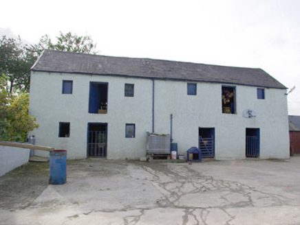
Explorer Tom Barn in Magheracorran has a grand external staircase leading straight up to its first-floor door. I bet the farmer…

Drumkeen Old GraveyardBurial ground · 1532 yd

Explorer Tom Drumkeen Old Graveyard is subcircular, a shape that whispers of ancient origins. St. Brigid’s holy well sits just two…

Standing stone in Lettermore (lettermore Ed)Standing stone · 1710 yd

Explorer Tom Standing stone in Lettermore is gone, but the spot was high up overlooking a river valley. I imagine the stone just…

Magheracorran Children's Burial GroundChildren's burial ground · 1732 yd

Explorer Tom Magheracorran Children's Burial Ground was marked as a Caldragh on an older map. The survey found no surface features…

Newtown BridgeBridge · 1.2 mi

Explorer Tom Newtown Bridge looks like it swallowed a whole hill just to get its arch wide enough for the Deele River. I reckon the…

Bullaun stone in Killynure or Wilsons FortBullaun stone · 1.6 mi

Explorer Tom Bullaun stone in Killynure Or Wilsons Fort sits right by the front door of a late 19th-century house. Why would anyone…
Killynure HouseHouse · 1.6 mi

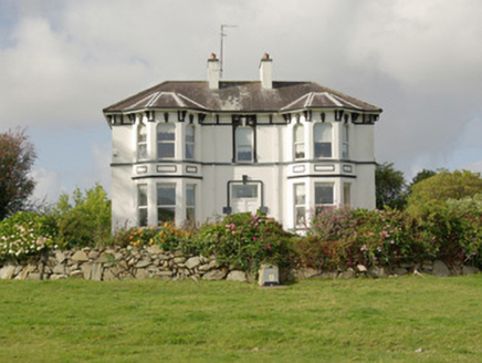
Explorer Tom Killynure House would tell a teenager that the 1800s were all about moulded brackets and feeling superior to everyone…

Megalithic tomb in KnockagarranMegalithic tomb · 1.6 mi

Explorer Tom Megalithic tomb in Knockagarran is a confused jumble of slabs perched above the Deele River valley. Experts can’t even…

Mapped cemeteryCemetery · 4.3 mi

Explorer Tom Mapped cemetery thinks the local sheep are its best critics, always grazing on the fresh green bits while offering zero…

Getting around Drumboe WoodsVisitor information · 4.3 mi

Explorer Tom Getting around Drumboe Woods refuses to fall down because it has a secret deal with the moss to hold it together in…

Battle of GlenmaquinBattle · 4.4 mi

Explorer Tom Battle of Glenmaquin would tell its younger self to stop caring so much about the Crown victory and just enjoy the mud…

Gorey HillMountain / peak · 5.3 mi

Explorer Tom Gorey Hill stands in County Donegal as a mountain peak with its access details completely unknown. The name sounds like…

More historic places in County Donegal · All of County Donegal

Add to this placeAdd a picture Add a detailed tip Add a story

Explore the map1,095,414 places to discover

Next place · or swipebarn