
What is recorded here
Detached three-bay two-storey house, built c.1830. Single-storey lean-to extension to the west side and complex of outbuildings to the rear (north). Hipped natural slate roof with overhanging eaves, two central red brick chimneystacks and cast-iron rainwater goods. Roughcast rendered walls over smooth rendered plinth…
Read the whole record
From the Buildings of Ireland (National Inventory of Architectural Heritage) record 15400313
Places near here
Picture notes
- National Inventory of Architectural Heritage
- Willow, Wikimedia Commons · CC BY 2.5
- Britishfinance, Wikimedia Commons · CC BY-SA 4.0
- Colin Park, Geograph · CC BY-SA 2.0
- Computer-made picture. It does not show this playground.
- Steve & Jemma Copley on Flickr, Wikimedia Commons · CC BY-SA 2.0
- Kieran Campbell, Geograph · CC BY-SA 2.0
- Cavanphotography, Wikimedia Commons · CC BY-SA 4.0
 Cross (Remains of)Cross, Wayside cross · 474 yd
Explorer Tom Cross (Remains of) has caught my eye in Robinstown Lower, County Westmeath. I bet a cross, wayside cross with a name like that could keep me talking all afternoon; I'm already inventing a daft little scene for it, and I'll stop before it turns into history.
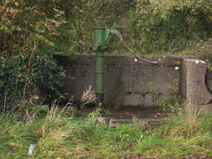 water pump542 yd
Explorer Tom Water pump in Ballycomoyle has caught my eye in Ballycomoyle, County Westmeath. I bet a water pump with a name like that could keep me talking all afternoon; I'm already inventing a daft little scene for it, and I'll stop before it turns into history.
 Ballycomoyle National SchoolSchool · 783 yd
Explorer Tom Ballycomoyle National School has caught my eye in Raheen More, County Westmeath. I bet a school with a name like that could keep me talking all afternoon; I'm already inventing a daft little scene for it, and I'll stop before it turns into history.
CrossCross, Wayside cross · 1082 ydExplorer Tom Cross has caught my eye in Robinstown Upper, County Westmeath. I bet a cross, wayside cross with a name like that could keep me talking all afternoon; I'm already inventing a daft little scene for it, and I'll stop before it turns into history.
 European ash2.0 mi
Explorer Tom European ash has caught my eye in County Westmeath. I bet a european ash with a name like that could keep me talking all afternoon; I'm already inventing a daft little scene for it, and I'll stop before it turns into history.
 Mullaghmeen ForestPicnic place · 2.1 mi
Explorer Tom Mullaghmeen Forest has caught my eye in County Westmeath. I bet a picnic place with a name like that could keep me talking all afternoon; I'm already inventing a daft little scene for it, and I'll stop before it turns into history.
 Mullaghmeen Red WalkWalking route · 2.5 mi
Explorer Tom Mullaghmeen Red Walk has caught my eye in County Westmeath. I bet a walking route with a name like that could keep me talking all afternoon; I'm already inventing a daft little scene for it, and I'll stop before it turns into history.
 Children's playground2.5 miComputer-made picture. It does not show this playground.
Explorer Tom Children's playground has caught my eye in County Westmeath. I bet a children's playground with a name like that could keep me talking all afternoon; I'm already inventing a daft little scene for it, and I'll stop before it turns into history.
 Mullaghmeen White WalkWalking route · 2.6 mi
Explorer Tom Mullaghmeen White Walk has caught my eye in County Westmeath. I bet a walking route with a name like that could keep me talking all afternoon; I'm already inventing a daft little scene for it, and I'll stop before it turns into history.
 Silver Fir2.6 mi
Explorer Tom Silver Fir has caught my eye in County Westmeath. I bet a silver fir with a name like that could keep me talking all afternoon; I'm already inventing a daft little scene for it, and I'll stop before it turns into history.
 CastleCastle, motte and bailey · 5.3 mi
Explorer Tom Castle has caught my eye in Castlecor, County Meath. I bet a castle, motte and bailey with a name like that could keep me talking all afternoon; I'm already inventing a daft little scene for it, and I'll stop before it turns into history.
 Myles O'Reilly MonumentMemorial · 5.8 mi
Explorer Tom Myles O'Reilly Monument has caught my eye in County Westmeath. I bet a memorial with a name like that could keep me talking all afternoon; I'm already inventing a daft little scene for it, and I'll stop before it turns into history.
More historic places in County Westmeath · All of County Westmeath
What do you know about this place?Tap to add a comment or ask a question