What is recorded here
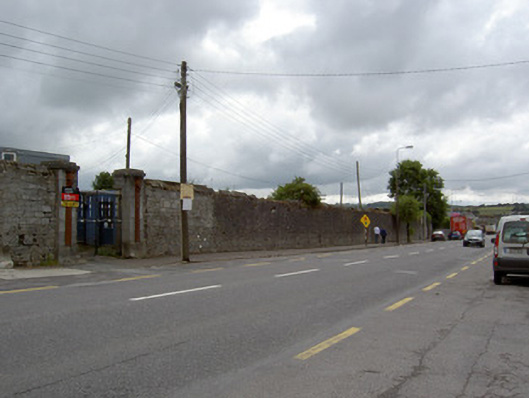
Freestanding rubble limestone boundary walls, built c. 1815, formerly forming south-west perimeter of military hospital. Cut limestone coping survives to some parts. Pair of dressed limestone square-profile piers to north end, having dressed limestone plinths and caps, with attached fluted pilasters having capitals. Recent cast-iron double-leaf gates. Square-headed pedestrian entrance to south with red brick surround, dressed limestone lintel and step. Dressed limestone square-profile piers to south with dressed limestone plinths and simple caps. Freestanding rectangular-profile cut limestone Ordnance boundary stone to south end of wall, with chamfered edges to front face and incised lettering. Set against rubble limestone boundary wall.
These tall walls form a distinctive feature on the Oliver Plunkett streetscape. They were formerly the boundary walls of the military infirmary, which served the barracks to the south. The finely carved piers survive and demonstrate the importance and grandeur of the site in former times. They also show the craftsmanship of the late eighteenth and early nineteenth centuries, forming a group with the barracks complexes to the south. The War Department boundary stone is significant as highlighting the military background to the boundary wall. Fermoy was an important garrison town in the nineteenth and early twentieth centuries and this marker is an interesting physical reminder of this military history.
From the Buildings of Ireland (National Inventory of Architectural Heritage) record 20821003
This does not grant access. Most recorded buildings are privately owned; view them only from public ground unless the owner allows entry.
Places near here
Photo credits
- National Inventory of Architectural Heritage
- Hywel Williams, Geograph · Creative Commons Attribution-ShareAlike 2.0
- Mike Searle, Geograph · CC BY-SA 2.0
 monument40 yd
 store/warehouse119 ydIndicatedGraveyard · 482 ydTourist InformationVisitor information · 950 ydKent BridgeMemorial · 957 ydGraveyard in FermoyGraveyard · 1010 yd
 St Bernards WellHoly well · 1096 yd
 Old Railway ViaductViewpoint · 1638 ydCarrigabrick Castle (in Ruins)Castle, tower house · 1710 yd
 Licklash Castle (in Ruins)Castle, hall-house · 1.2 miBallybrack WoodForest · 1.7 miStrawhall WoodForest · 1.9 mi
More historic places in County Cork · All of County Cork
What do you know about this place?