
What is recorded here
From the National Monuments Service (Archaeological Survey of Ireland) record DU015-091
Places near here
Photo credits
- Maker not stated on source page, en.wikipedia.org
- National Inventory of Architectural Heritage
- Nigel Thompson, Geograph · Creative Commons Attribution-ShareAlike 2.0
- Kieran Campbell, Wikimedia Commons · CC BY-SA 2.0
- JacK93, Wikimedia Commons · CC BY-SA 4.0
- Eirian Evans, Wikimedia Commons · CC BY-SA 2.0
- Kieran Campbell, Geograph · CC BY-SA 2.0
- Maker not stated on source page, www.alamy.com
 Earthwork in Tyrrelstown Big (detached Portion)Earthwork · 728 yd
Explorer Tom Earthwork in Tyrrelstown Big is a circular cropmark about thirty meters across, visible on Google Maps. It has a ditch…
 Horestone HouseFarm house · 864 yd
Explorer Tom Horestone House in Horestown is a farm house from the 1920s that looks like it just stepped out of a very sensible…
 Rush and Lusk Railway StationRailway station · 1099 yd
Explorer Tom Rush and Lusk Railway Station in Effelstown has a cast-iron pedestrian bridge linking the platforms. It’s been standing…
 Rusk and Lusk Railway StationStation master's house · 1113 yd
Explorer Tom Rusk and Lusk Railway Station's master's house in Rogerstown is a gable-fronted gem from 1870. It’s got a flat-roofed…
 Fingal HouseHouse · 1187 yd
Explorer Tom Fingal House in Lusk is an 1860s show-off with pebble-dashed walls and tripartite sash windows. It’s got outbuildings…
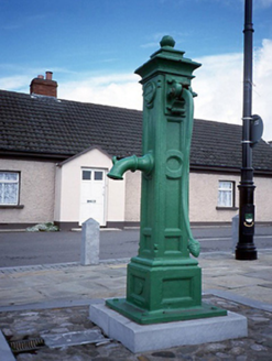 water pump1188 yd
Explorer Tom Water pump in Lusk is hiding a biscuit tin from 1925 under that fancy acorn cap. Tonge and Taggart made it look posh…
 Saint MacCullin's Church (Lusk)Church/chapel · 1259 yd
Explorer Tom Saint MacCullin's Church in Lusk is wearing its medieval tower like a fancy hat while pretending to be a modern…
 Graveyard in LuskGraveyard · 1260 yd
Explorer Tom Graveyard in Lusk has a low stone wall that’s been collapsed and repaired many times. It contains the Echlin tomb of…
 Round tower1265 yd
Explorer Tom Round tower in Lusk is a detached north-east turret to the belfry tower and has eight floors under a conical roof. It’s…
 Lusk Round TowerVisitor attraction · 1265 yd
Explorer Tom Lusk Round Tower has been standing there looking smug since before anyone knew what a round tower was supposed to do.…
 Church in LuskChurch · 1266 yd
Explorer Tom Church in Lusk has a massive medieval tower standing on a natural rise. The original church was huge with two aisles…
 TombTomb, effigial (present location) · 1269 yd
Explorer Tom This Tomb in Lusk has a dating profile that reads: 'Seeking second husband to bury me with my first.' Marion Sharl had…
More archaeology and monuments in County Dublin · All of County Dublin

What do you know about this place?Tap to add a comment or ask a question