
What is recorded here
From the National Monuments Service (Archaeological Survey of Ireland) record DG061-019
Places near here
Photo credits
- National Inventory of Architectural Heritage
- Maker not stated on source page, ro.pinterest.com
- Richard Webb, Wikimedia Commons · CC BY-SA 2.0
- Maker not stated on source page, commons.wikimedia.org
- Maker not stated on source page, ru.pinterest.com
- Maker not stated on source page, tr.pinterest.com
- Balloholic (talk), Wikimedia Commons
- Dr Neil Clifton, Geograph · CC BY-SA 2.0
 bridge1029 yd
Explorer Tom Bridge in Cornagillagh carried a road over the three-foot Strabane to Letterkenny railway, opened in 1909. Its…
 Standing stone in Glenmaquin LowerStanding stone · 1.1 mi
Explorer Tom Standing stone in Glenmaquin Lower is a modest monument about 0.75m high, set upon a small earthen platform on a…
 Battle of GlenmaquinBattle · 1.4 mi
Explorer Tom Battle of Glenmaquin would tell its younger self to stop caring so much about the Crown victory and just enjoy the mud…
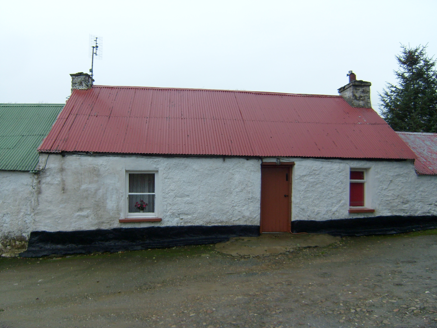 farmyard complex1.5 mi
Explorer Tom Farmyard complex in Glenmacquin Lower includes a house built around 1830, likely once thatched and later covered in…
 Bullaun stone in DooballaghBullaun stone · 1.6 mi
Explorer Tom Bullaun stone in Dooballagh is waiting for its full story to be told, as the details are still being gathered. It’s…
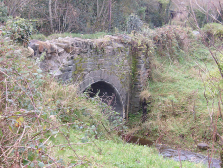 Foundry BridgeBridge · 1.7 mi
Explorer Tom Foundry Bridge carries the road over Dooballagh Burn beside the spot where a smithy stood around 1905. Built around…
 Standing stone in Convoy TownparksStanding stone · 1.9 mi
Explorer Tom Standing stone in Convoy Townparks is totally gone, just like a kid who hid so well nobody found them. I bet it’s under…
 Standing stone in Tullydonnell LowerStanding stone · 2.2 mi
Explorer Tom Standing stone in Tullydonnell Lower used to stand on rolling pasture land, which is where the cows hang out. I wonder…
 Tullydonnell HouseHouse · 2.2 mi
Explorer Tom Tullydonnell House has fluted pilasters holding up the door. They look like two very serious butlers making sure nobody…
Battlefield in Tully (kincraigy Ed),glenmaquin Lower,roosky (castleforward Ed)Battlefield · 2.3 miExplorer Tom Tully, Glenmaquin Lower had a fox that took charge of the whole operation once, probably because it was smarter than…
 Ballymacool ParkPark · 4.7 mi
Explorer Tom Ballymacool Park sits just outside Letterkenny with the excellent confidence of a place that knows a good hill, a broad…
 Newmills Corn and Flax MillsHeritage attraction · 5.3 mi
Explorer Tom Newmills Corn and Flax Mills has a working waterwheel so large it makes my own efforts at getting a day's work done…
More archaeology and monuments in County Donegal · All of County Donegal

What do you know about this place?Tap to add a comment or ask a question