DDiscover AloneMapAbout

Hms Corientes

Steam Trawler-(1917)

What is recorded here

Corientes was a 1910 steam trawler converted into a Royal Navy minesweeper. She struck a mine on 23 June 1917 north-east of Malin Head and sank with thirteen crew. A memorial in Brightlingsea names 42-year-old A. R. Beales among the dead. The saved offshore point is only a possible Corientes position and differs from…

Read the whole record

Corientes was a 1910 steam trawler converted into a Royal Navy minesweeper. She struck a mine on 23 June 1917 north-east of Malin Head and sank with thirteen crew. A memorial in Brightlingsea names 42-year-old A. R. Beales among the dead. The saved offshore point is only a possible Corientes position and differs from the commonly quoted wartime coordinates, so the loss story is firm while the hull at this pin is not.

The vessel and voyage

Corientes was a steam trawler built in 1910 and taken into Royal Navy service as a minesweeper during the First World War. Fishing trawlers were suited to pulling sweep gear and already carried crews experienced with heavy work in rough water. The quick records do not give her builder, home port, tonnage, commanding officer or the exact sweep assignment on 23 June 1917. Her presence near Malin Head placed her on a vital northern approach.

How it was lost

Corientes struck a mine and sank on 23 June 1917, commonly placed about four nautical miles north-east of Malin Head. The checked source does not securely name the submarine or ship that laid the mine. The saved national record openly calls its wreck match possible, and its point is noticeably east of the widely quoted 55 degrees 27 minutes north, 7 degrees 24 minutes west loss position. The cause and date are secure; the exact hull location is not.

Deaths and survival

Thirteen members of the crew died. A memorial tile in All Saints Church, Brightlingsea, specifically remembers A. R. Beales, aged 42, as lost with the trawler on 23 June 1917. The quick sources do not give survivor numbers or the other twelve names. That one local memorial shows how a mine loss far off Donegal reached an English fishing community. A full Royal Naval Patrol Service or war-grave list should eventually restore every person.

What remains

Record 322611 marks a seabed point labelled possibly Corientes, not a wreck identified by a bell or numbered machinery. Its coordinates do not closely match the commonly published loss position north-east of Malin Head. No depth, length, orientation or condition is supplied in the saved entry. The point may represent a later survey target, an older plotting conversion or another wreck. It should remain a candidate until measurements match the trawler or an identifying object is found.

Why it mattered

Corientes represents the dangerous minesweeping work carried out by converted fishing vessels. The crew had to enter water suspected of holding mines so that larger naval and merchant ships could pass more safely. Their loss also joins Malin Head to Brightlingsea and other crew home towns. The uncertain map point matters because moving thirteen deaths to the wrong hull would weaken that real connection; a possible record can guide research without pretending the identification is settled.

Sources for this account

Sources checked 2026-08-15.

From the Historic Environment Scotland record 322611

The historic-place record does not grant public access. Check current conditions and ownership before entering land or a building.

What do you know about this place?Tap to add a comment or ask a question

What you write will be public.

Places near here

Photo credits
  • Maker not stated on source page, www.pinterest.com
  • National Inventory of Architectural Heritage
  • Andreas F. Borchert, Wikimedia Commons · CC BY-SA 4.0
  • Kenneth Allen, Geograph · Creative Commons Attribution-ShareAlike 2.0
  • Kenneth Allen, Geograph · CC BY-SA 2.0
  • Maker not stated on source page, ru.pinterest.com
  • Donegal Daily; photographer not named, Source publisher
  • N Chadwick, Geograph · CC BY-SA 2.0
Unbaptised babies cemeteryCemetery · 3.3 mi

Explorer Tom Unbaptised babies cemetery in County Donegal would order a massive portion of chips with extra mayo if it were alive…

Lougherbraghy Children's Burial GroundChildren's burial ground · 3.4 mi

Explorer Tom Lougherbraghy Children's Burial Ground is a lumpy earthen mound sitting right by a stream curve. It’s locals who named…

farm house4.5 mi

Explorer Tom Farm house in Magheryard is a c. 1880 classic that keeps its original sash windows and slate roof intact, which is rare…

Donowen Promontory FortPromontory fort, coastal · 4.5 mi

Explorer Tom Donowen Promontory Fort hides shapeless stone mounds that might be the ghost of a 16th-century O'Doherty castle. That’s…

Iron Age Promontory FortArchaeological place · 4.5 mi

Explorer Tom Iron Age Promontory Fort is perched right over that wild stretch of Girt Bay. I can hear the waves arguing about who…

CastleCastle, unclassified · 4.5 mi

Explorer Tom Castle in Carthage may survive only as shapeless stone mounds on a promontory. The survey thought they might belong to…

Bunagee PierPier/jetty · 4.7 mi

Explorer Tom Bunagee Pier has been holding the line against the Donegal swell since c. 1870. It’s a proper limestone beast with…

lifeboat station4.7 mi

Explorer Tom Lifeboat station in Carthage looks grand, but it saved more than just sailors. In 1894, the crew raced to Inishtrahull…
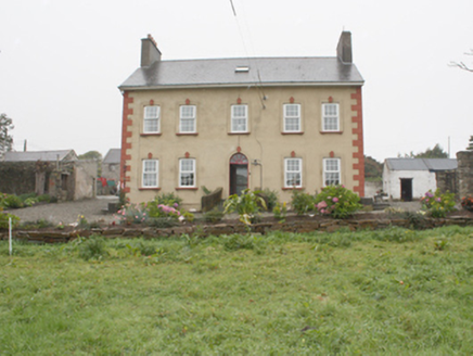
Carthage HouseHouse · 4.7 mi

Explorer Tom Carthage House in Carthage is a real survivor from 1775, wearing its classical front like a proud badge. The…

Castle FortArchaeological place · 5.6 mi

Explorer Tom Castle Fort is recorded as an archaeological place in County Donegal, and its name suggests a spot where people built…

Connolly Park, MalinGAA ground · 6.0 mi

Explorer Tom Connolly Park is Malin’s proud patch of Gaelic games, up near the tip of Inishowen where an away team has already had…

Explorer Tom approvedE. McCleanRestaurant · 6.1 mi

Explorer Tom E. McClean is a great restaurant now, with lunch or dinner worth turning up for. Tom says that if you're lucky, you…

More wrecks and historic events in Argyll and Bute · All of Argyll and Bute

Add to this placeAdd a picture Add a detailed tip Add a story

Explore the map1,095,414 places to discover

Next place · or swipeUnbaptised babies cemetery