
Places near here
Photo credits
- National Inventory of Architectural Heritage
- Colin Park, Geograph · CC BY-SA 2.0
- Slamforeman, Wikimedia Commons · CC BY 4.0
- Oliver Dixon, Geograph · CC BY-SA 2.0
- Audrius Janecka, Wikimedia Commons · CC BY-SA 4.0
- Stephan van Helden, Wikimedia Commons · CC BY-SA 4.0
- BrendanLacey72, Wikimedia Commons · CC BY-SA 4.0
Explorer Tom Gort Na Duimhche Íochtarach is a settlement cluster that seems to have vanished into thin air, leaving only a name behind. They built a whole street there, and then just decided to move on without telling anyone. Look for the ghost, then pretend you didn't.
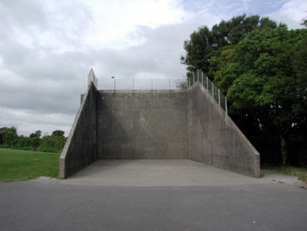 Coláiste na Rinne [Ring College]Handball alley · 519 yd
Explorer Tom Coláiste na Rinne in Mweelahorna is a handball alley built during the independent state movement, which means it’s got serious national pride baked into its walls. I once heard a bishop refused to visit because he said the walls were too intimidating for his vestments. It’s indigenous to Ireland and looks like it could take a punch or two.
 farmyard complex639 yd
Explorer Tom Farmyard complex in Mweelahorna would win a county fair prize for 'Most Confused Animals' because its informal courtyard layout is a total maze. The vernacular buildings are modest, but they stand together like a group of friends who can’t agree on where the door actually is. Go take a photo before the cows get confused!
St Nicholas WellHoly well · 1070 ydExplorer Tom St Nicholas Well in An Móta would tell a teenager that the 1800s were all about fancy hats and bad plumbing. Its wall got swept away in a torrent, which is what happens when you don't check the weather app. It's the kind of place that makes a dull Tuesday interesting.
 Cunnigar PointHeadland · 2.6 mi
Explorer Tom Cunnigar Point really dislikes when tourists try to take selfies with their backs turned. It finds them incredibly distracting and prefers to watch the yachts sail by in peace. Ideal for a moody photo you'll pretend wasn't posed.
Ceann HeilbhicHeadland · 2.6 miExplorer Tom Ceann Heilbhic means 'The Head of the Bad Dream,' or so I was told recently. It’s probably just a rock, but it looks like it’s seen things and isn’t telling. Perfect place to be dramatically windswept.
 Waterford County MuseumMuseum · 2.9 mi
Explorer Tom Waterford County Museum has misplaced its sense of direction and ended up parked next to a chip shop by pure accident. I’m telling you, the exhibits are probably hiding behind the tea urn because they’re shy about being so local. Go at sunset and thank me later.
 Dungarvan Castle (in Ruins)Castle, Anglo-Norman masonry castle · 2.9 mi
Explorer Tom Dungarvan Castle in Dungarvan is secretly proud of a potato that grew inside its wall in 1902 and was eaten by a soldier who didn’t even leave a thank-you note. It’s been a barracks, a prison, and now just a very tired building looking at the water. Snap one photo, then put the phone away and actually look.
 Dungarvan CastleCastle · 2.9 mi
Explorer Tom Dungarvan Castle in County Waterford would order a massive chipper with extra sauce if it could actually eat. It’s seen kings and queens come and go, but it still thinks it’s the main dish. Go with someone who loves old stuff and watch them melt.
 Grattan SquareVisitor information · 3.0 mi
Explorer Tom Grattan Square would say in a job interview that its main strength is 'holding space' and its weakness is 'pigeon droppings.' It’s just a square in Dungarvan with a big ego about being the center of town life. It thinks every conversation happening on its benches is a state secret it needs to protect. Bring your worst joke, the place has heard worse.
 Horse-chestnut4.6 mi
Explorer Tom Horse-chestnut in County Waterford is sick of being asked if its fruits are actually edible, especially when they taste like disappointment. It just wants people to appreciate the shape of it instead of trying to eat it. It's the kind of place that makes a dull Tuesday interesting.
 Master McGrathMemorial · 5.3 mi
Explorer Tom The shortcut near Master McGrath is definitely not a shortcut; it’s just a very long walk with extra steps. But the legend says if you run fast enough, you can catch your own shadow. Have a nosey, politely.
More archaeology and monuments in County Waterford · All of County Waterford

What do you know about this place?Tap to add a comment or ask a question