What is recorded here
In the course of advance archaeological testing for the N22 Ballincollig Bypass a spread of dark-brown/black sandy silt containing charcoal was discovered. Excavation revealed the deposit to be c. 1.4m in diameter and c. 0.03m deep and it overlay a smaller deposit (diam. c. 1.2m; D 0.05m) of red/brown silty clay. (Murphy 2003f, 47)
The above description is derived from 'The Archaeological Inventory of County Cork. Volume 5' (Dublin: Stationery Office, 2009).
From the National Monuments Service (Archaeological Survey of Ireland) record CO073-129
The monument record does not grant public access. Check the route and ask the landowner before entering private land.
- What survives
- Recorded monument
Places near here
Photo credits
- National Inventory of Architectural Heritage
- Hywel Williams, Geograph · Creative Commons Attribution-ShareAlike 2.0
- Brendandiamond, Wikimedia Commons · CC BY-SA 3.0
- Mike Searle, Geograph · CC BY-SA 2.0
- Hywel Williams, Geograph · CC BY-SA 2.0
- Richard Fensome, Wikimedia Commons · CC BY-SA 2.0
 bridge1084 yd
 Classes HouseCountry house · 1101 ydGraveyard in Carrigane (muskerry East By.)Graveyard · 1355 yd
 Grave YardGraveyard · 1752 ydHugh MaguireMemorial · 1.0 miGrange HillMountain / peak · 1.1 mi
 Ballincollig CastleCastle · 1.4 mi
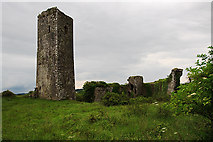 Ballincollig Castle (in Ruins)Castle, tower house · 1.4 miCave in Ballincollig (muskerry East By., Carrigrohane Par.)Cave · 1.4 mi
 waterfallVisitor information · 3.7 mi
 Kilcrea CastleWood · 3.8 mi
 Grave YardGraveyard · 4.7 mi
More archaeology and monuments in County Cork · All of County Cork
What do you know about this place?