Places near here
Photo credits
- Maker not stated on source page, tr.pinterest.com
- National Inventory of Architectural Heritage
- Maker not stated on source page, www.pinterest.com
- Maker not stated on source page, www.tripadvisor.ie
- Oliver Dixon, Wikimedia Commons · CC BY-SA 2.0
- Neil Theasby, commons.wikimedia.org
- Gordon Hatton, Geograph · CC BY-SA 2.0
- Maker not stated on source page, readymap.irish
- Graham Horn, Wikimedia Commons · CC BY-SA 2.0
 Gragan CastleCastle, tower house · 1.0 mi
Explorer Tom Gragan Castle in Gragan West is playing hard to get. O'Donovan says it was the Burren's big house, but now it's just a…
 Gregans CastleHouse · 1.1 mi
Explorer Tom Gregans Castle in Gragan East, County Clare, is throwing a massive fit because some bloke added a hotel wing to it in…
 Cist in LislarheenmoreCist · 1.4 mi
Explorer Tom Cist in Lislarheenmore set itself a New Year's resolution to be found by someone other than the same two guys who've…
 Wedge tomb in CaherbullogWedge tomb · 2.2 mi
Explorer Tom Wedge tomb in Caherbullog is hiding in dense hazel scrub, which means you’ll need to be very lucky or very bad at…
 Noughaval Church (in ruins)Church · 3.5 mi
Explorer Tom Noughaval Church is being picked on by the wind because it stands right on the edge of a slope, which means it gets…
 Site of Kilcameen ChurchChurch · 4.7 mi
Explorer Tom Site of Kilcameen Church has vanished so completely that even the wind can’t find anything to pick on anymore. It’s…
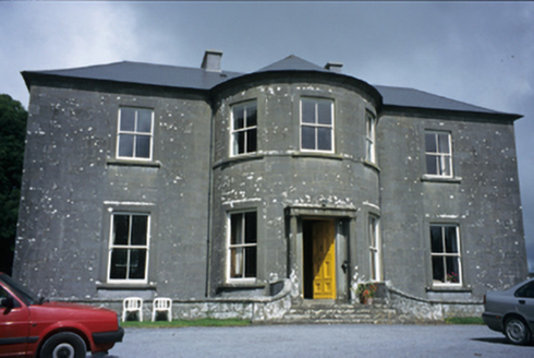 Ballykeel HouseCountry house · 4.7 mi
Explorer Tom Ballykeel House in Ballykeel South is a c. 1800 country house with a bowed central section that looks like it’s trying…
 Kilfenora GAA pitchGAA ground · 5.0 mi
 Trá an DóilínBeach / strand · 22 mi
Explorer Tom Trá an Dóilín has been changing its name so often that even the Google Maps team have given up on keeping track of it.…
 Mapped cemeteryCemetery · 22 mi
Explorer Tom I suspect this Mapped Cemetery in County Galway ended up in the wrong place because a very drunk surveyor misread his…
 Graveyard in Tír An FhiaGraveyard · 22 mi
Explorer Tom Graveyard in Tír An Fhia had a fox take full charge of the headstones last winter, rearranging them for fun. It looks…
 GarmnaIsland · 24 mi
Explorer Tom Gorumna makes you work out whether you are still on the mainland, and I am happy to get that question wrong for a…
More caves in County Clare · All of County Clare

What do you know about this place?Tap to add a comment or ask a question