What is recorded here
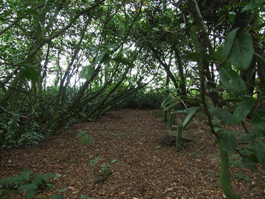
Burial ground, opened 1666. Closed, 1957. Set in wooded grounds on a corner site with piers to perimeter having rendered rounded pyramidal capping supporting flat iron gate.
A burial ground representing an important component of the ecclesiastical heritage of County Wexford. The burial ground occupies a roughly circular wooded rath [SMR WX032-024001-] and was used by several meetings of the Religious Society of Friends including the Corlican meeting as well as the Forest meeting until 1783 (see 15703614) and the Cooladine meeting until 1799 (see 15702644). The earliest burials, now unmarked, included Sarah Holme (d. 1676), wife of Thomas Holme (d. 1695), Surveyor General of Pennsylvania; Robert Cuppage (d. 1683); and Francis Randall (d. 1692). The first formal lease (1816) gave the extent of the burial ground as 1 r. [rood] and 20 p. [perches]. The last burial was made in 1953 (Butler 2004, 42).
This does not grant access. Most recorded buildings are privately owned; view them only from public ground unless the owner allows entry.
Places near here
 Killurin HouseRIC barracks · 1407 yd
 Killurin Railway Stationrailway station · 1466 yd
 Embanked enclosurePromontory fort, inland · 1699 yd
 site of Killell ChurchChurch · 1.1 mi
 CastleCastle, tower house · 1.2 mi
 Site of CastleCastle, unclassified · 1.3 mi
 Celebrating 125 YearsMemorial · 1.5 mi
 Raheennahoon HillMountain / peak · 3.5 mi
 Irish National Heritage ParkHeritage attraction · 4.2 mi
 Fulacht FiadhHeritage attraction · 4.3 mi
 Battle Of The Three RocksMemorial · 4.5 mi
 Battle of Three Rocksbattle · 4.6 mi
Other information
Photo: National Inventory of Architectural Heritage · Website use allowed for educational or private purposes with source credit