What is recorded here
Located on a shelf that slopes down gently to the N with slightly lower ground to the W before a hill rises over the town of Castleblayney, but the ground falls away steeply to the N and E. The parochial centre of Muckno parish moved from the site of St Maodóid’s monastery and the medieval parish church at Church Hill (MO020-020001-), on the E shore of Lough Muckno, to Castleblayney during the seventeenth century. William, the sixth Lord Blayney probably built the church (MO020-027----) at the N end of a subrectangular graveyard (dims c. 170m NNW-SSE; c. 60m ENE-WSW) defined by masonry walls. The oldest memorials dating from c. 1770 are around this structure on a slightly rising area (diam. c. 45m), forming the original graveyard. The present Church of Ireland church of St Maeldoid which was built in 1858-60 is a replacement for a church on the same site at the centre of the graveyard that was built in 1810 (Lewis 1837 vol. 2, 408)
Compiled by: Caimin O'Brien
Revised by: Michael Moore
Date of revised upload: 22 June 2017
Located on a shelf that slopes down gently to the N with slightly lower ground to the W before a hill rises over the town of Castleblayney, but the ground falls away steeply to the N and E. The parochial centre of Muckno parish moved from the site of St Maodóid’s monastery and the medieval parish church at Church Hill (MO020-020001-), on the E shore of Lough Muckno, to Castleblayney during the seventeenth…
From the National Monuments Service (Archaeological Survey of Ireland) record MO020-027001
The monument record does not grant public access. Check the route and ask the landowner before entering private land.
- What survives
- Recorded monument
Places near here
Photo credits
- National Inventory of Architectural Heritage
- Dean Molyneaux, Wikimedia Commons · CC BY-SA 2.0
- Shane Killen, Wikimedia Commons · CC BY-SA 2.0
- Eric Jones, Geograph · CC BY-SA 2.0
- Eric Jones, Geograph · Creative Commons Attribution-ShareAlike 2.0
 Saint Maeldoid's Church (Muckno)Mausoleum · 15 yd
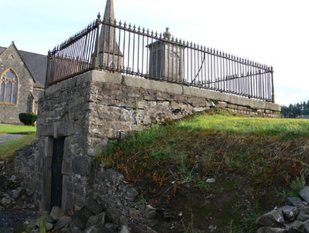 Saint Maeldoid's Church (Muckno)Mausoleum · 27 ydBawn in OnomyBawn · 153 yd
 Blaney CastleCastle · 199 ydBig Tom Memorial StatueMemorial · 336 ydThe CrescentMemorial · 1074 yd
 Lough MucknoLake and park landscape · 1495 yd
 Crane IslandIsland · 1.9 mi
 Crannog in lisleitrim lough in Kiltybane or LisleitrimCrannog in Lisleitrim Lough · 4.3 mi
 MullavashPassage tomb · 4.7 mi
 Mullyash MountainMountain / peak · 4.7 mi
 Tullyvallen Orange Hall massacreMassacre · 6.1 mi
More archaeology and monuments in County Monaghan · All of County Monaghan
What do you know about this place?