
Places near here
Photo credits
- National Inventory of Architectural Heritage
- Mike Searle, Geograph · CC BY-SA 2.0
- Rogue29567, Wikimedia Commons · CC BY-SA 4.0
- Rob Hodgkins, Wikimedia Commons · CC BY-SA 2.0
- H., Wikimedia Commons · Public domain
- Michael O'Sheil, Wikimedia Commons · CC BY-SA 4.0
- P L Chadwick, Wikimedia Commons · CC BY-SA 2.0
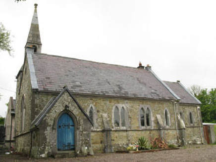 church/chapel112 yd
Explorer Tom The Church in Killanully is pretending to be a house now, but it’s still wearing its Victorian polychrome makeup from 1865. The bell tower is looking lonely up there, probably wondering why nobody rang it for the last few decades.
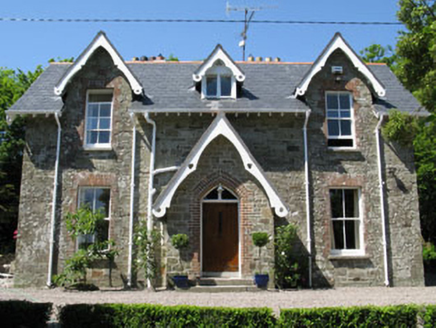 rectory/glebe/vicarage/curate's house125 yd
Explorer Tom Rectory in Killanully is showing off its Victorian brick and timber details. Built around 1865, it’s got a nice porch and a lean-to extension. It looks like it’s waiting for a vicar who never turned up. Ring the bell!
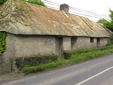 Historic buildingOfficially recorded historic building · 294 yd
Explorer Tom Historic building in Killanully is a vacant vernacular house from around 1790 with a corrugated-iron roof that was probably thatched before. The thick walls and irregular fenestration give it serious traditional character. It’s set on the roadside, so wave to its empty windows.
 Church of the Holy Mary Mother of GodOutbuilding · 1070 yd
Explorer Tom Church of the Holy Mary Mother of God is an outbuilding, which is a weird title for something holy. I bet two lads in the pub made a bet that started this whole split-level design thing. Twist your head around once to appreciate the oddity.
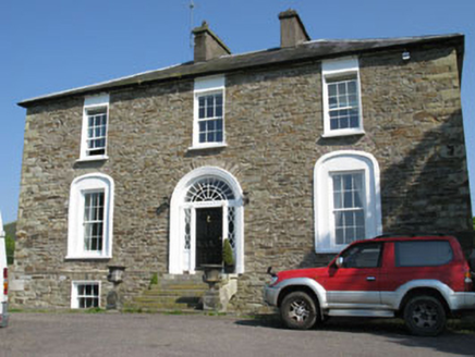 Ballygarvan HouseHouse · 1.3 mi
Explorer Tom Ballygarvan House has a symmetrical facade and paired chimneystacks that look like they’re ready for a very stuffy dinner party. The whole parish probably argued about which chimney was taller back in the day. Mind you don’t get lost in it!
 Ballea CastleCastle, tower house · 1.3 mi
Explorer Tom Ballea Castle in Ballea sits on a cliff above the Owenboy River. The FitzGeralds built it back in 1439, and it’s been renovated since. It’s got an iron grille on the door that looks pretty intimidating.
 Ballea Bridge (Upper)Bridge · 1.3 mi
Explorer Tom Ballea Bridge (Upper) has a family tree mostly made up of bridges that don’t exist. It fits seamlessly into the landscape because it’s shy. Perfect for hiding from your ex, or at least their bad jokes.
 Ballea Bridge (Lower)Bridge · 1.6 mi
Explorer Tom Ballea Bridge (Lower) blends into the landscape so well that even the rabbits think it's just a fancy rock they can nap on. It crosses the Owenboy with such style that I bet it judges every car that passes by. Give a little wave to those confused bunnies; they probably think they own the place now.
_(40783618904).jpg/250px-Manx2_EC-ITP_Metro_EMA(5)_(40783618904).jpg "Photo: Rob Hodgkins, Wikimedia Commons · CC BY-SA 2.0") Manx2 Flight 7100Aviation accident · 1.9 mi
Manx2 Flight 7100Aviation accident · 1.9 miExplorer Tom Manx2 Flight 7100 is doing a bit of aerial limbo over County Cork. Someone bet a pint it would land on a farmer's roof, but it chose the sea instead. Bring a map, get lost anyway, that's the fun.
 Carrigaline Castle (in Ruins)Castle, Anglo-Norman masonry castle · 3.5 mi
Explorer Tom Carrigaline Castle in Carrigaline East is hiding behind a lot of ivy and quarried stone. Only half the tower is really standing, but it looks mysterious. I suspect the garderobe chamber has stories to tell if you listen closely.
 Father MatthewMonument · 5.1 mi
Explorer Tom Father Matthew is a monument to a man who probably had a ghost that was too lazy to haunt it because the paperwork was too complicated and annoying. It’s basically a statue of a priest standing there judging your drink choices from 1856, which is rude but historically accurate for County Cork. Bring sandwiches, the gulls will thank you.
 Lavitts QuayMemorial · 5.1 mi
Explorer Tom Lavitts Quay is a memorial where, legend has it, a goat once ruled the harbour by eating all the navigation charts before the tide came in. Now it’s just rocks and stories, but if you look closely, you can still see the hoofprints of that terrible beast. Bring your worst joke, the place has heard worse.
More archaeology and monuments in County Cork · All of County Cork

What do you know about this place?Tap to add a comment or ask a question