Places near here
Photo credits
- National Inventory of Architectural Heritage
- Mike Searle, Wikimedia Commons · CC BY-SA 2.0
- No machine-readable author provided. Christian1965~commonswiki assumed (based on copyright claims)., Wikimedia Commons · Public domain
- Jon Sullivan, Wikimedia Commons · Public domain
- Joseph Mischyshyn, Geograph · Creative Commons Attribution-ShareAlike 2.0
- Miguel Angel Masegosa Martínez, Wikimedia Commons · CC BY 2.0
- Colin Park, Geograph · CC BY-SA 2.0
- Darrin Antrobus, Wikimedia Commons · CC BY-SA 2.0
 Cahervally HouseRectory/glebe/vicarage/curate's house · 215 yd
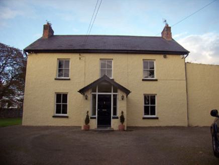
Explorer Tom Cahervally House’s builder was really thinking 'how do I hide this fanlight so nobody sees it?' The glebe house has views over wooded grounds, but it feels like it’s hiding from them. Bring the dog, it’ll sniff out exactly why the doorcase looks shy today.
 Orchard HouseHouse · 404 yd
Explorer Tom Orchard House in Lemonfield was invented by a local who just woke up from a nap. Its sliding sash windows are doing all the talking. Take a breath of fresh air, it’s cheaper than therapy.
 post box1.0 mi
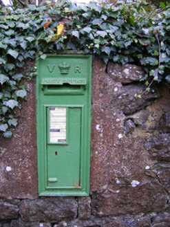
Explorer Tom The post box in Bawnacouma rates its visitors out of ten based on handwriting quality. It’s been casting iron opinions since the late empire days without resting. Perfect detour when you need a little historical judgment.
 Kilpeacon HouseGate lodge · 1.2 mi
Explorer Tom Kilpeacon House in Kilpeacon is a gate lodge that would sue the council for insufficient curb appeal. Its square plan and breakfront are trying too hard, frankly. Go with someone who appreciates symmetry over substance.
_-_geograph.org.uk_-_4570265.jpg/250px-Castles_of_Munster,_Ballinveala,_Limerick_(3)_-_geograph.org.uk_-_4570265.jpg "Photo: Mike Searle, Wikimedia Commons · CC BY-SA 2.0") Ballinveala Castle (in ruins)Castle, tower house · 3.0 mi
Ballinveala Castle (in ruins)Castle, tower house · 3.0 miExplorer Tom Ballinveala Castle nearly got famous when someone almost found it but looked in the wrong field. It’s four stories of brickwork pretending to be taller than it actually is. Take the long way round, it deserves the effort.
_-_geograph.org.uk_-_6276354.jpg/250px-Castles_of_Munster,_Fanningstown,_Limerick_(1)_-_geograph.org.uk_-_6276354.jpg "Photo: Mike Searle, Wikimedia Commons · CC BY-SA 2.0") Fanningstown Castle (in ruins)Castle, tower house · 5.1 mi
Fanningstown Castle (in ruins)Castle, tower house · 5.1 miExplorer Tom Fanningstown Castle holds the world record for the most confusing conversion from ruin to luxury B&B. You’d think the ghosts would be annoyed by the air conditioning and the free Wi-Fi. Bring a coin for luck and keep it in your pocket.
 Áine and Gearóid Iarla: Lough GurLegend location · 7.3 mi
Explorer Tom Áine and Gearóid Iarla: Lough Gur has a goddess for the lake and a sleeping lord in the old stories. I thought I was coming to admire water and stones. Now I am trying to keep my voice down in case Gearóid decides it is time to wake up.
 Bunratty CastleCastle · 9.8 mi
Explorer Tom Bunratty looks ready to argue with anyone coming up the river. Bunratty Castle stands where the Ratty River meets the Shannon, which is exactly what its Irish name tells you if you ask it politely. The tower you see is a 15th century MacNamara job, but this site had already chewed through several earlier castles. Richard de Clare's stone stronghold met a particularly brisk end in 1318: after he died at Dysert O'Dea, Lady de Clare burned castle and town before fleeing to Limerick. You can imagine the neighbours deciding not to ask how her day went. I'd have asked the lord for a room, then remembered I prefer doors I can open myself. The present tower survived to become one of Clare's most recognisable sights, with rooms that make the scale of a medieval household much easier to grasp than any tidy date on a plaque. The castle and folk park are managed visitor attractions, so check current admission and opening hours before setting out. Go for the stonework, stay long enough to hear the river making its own quiet argument about who really owns the place.
 Graveyard9.9 mi
Explorer Tom Graveyard in Bunratty West is hanging out right behind the castle hotel, which feels like standing in someone's kitchen. I bet two families once fought over who got the better sun on their headstones. Look up, because the best gossip is always above your eye level.
 Sweet Chestnut10 mi
Explorer Tom Sweet Chestnut in County Clare was planted by a builder who was really thinking about how many sandwiches he could eat under its shade during lunch breaks. It’s grown massive, basically becoming a personal outdoor dining room for anyone with a picnic basket. Ideal for a moody photo you'll pretend wasn't posed.
 KnockfeerinaMountain / peak · 11 mi
Explorer Tom Knockfeerina thinks the road leading to it is too fancy for a humble peak, so it pretends not to be there. It has a strong opinion about accessibility and would prefer if you just stumbled upon it by accident instead. Ten minutes here and you'll have a yarn for the pub.
 Atlantic Air VentureMuseum · 12 mi
Explorer Tom Atlantic Air Venture in County Clare would tell its younger self to stop worrying about landing gear and just enjoy the wind in its face more. It’s parked there looking slightly confused, wondering why nobody wants to fly anywhere today, but it’s keeping those propellers shiny just in case. Ideal stop for a big stretch and a bigger yawn.
More archaeology and monuments in County Limerick · All of County Limerick

What do you know about this place?Tap to add a comment or ask a question