What is recorded here
From the National Monuments Service (Archaeological Survey of Ireland) record LI022-117002
Places near here
Photo credits
- Maker not stated on source page, au.pinterest.com
- Willow, Wikimedia Commons · CC BY 2.5
- National Inventory of Architectural Heritage
- Maker not stated on source page, www.tripadvisor.com.au
- Maker not stated on source page, www.geograph.ie
- JohnArmagh, Wikimedia Commons · Public domain
- Mike Searle, Wikimedia Commons · CC BY-SA 2.0
 Church (in ruins)Church · 16 yd
Explorer Tom Church in Knocknagranshy is posting a selfie with a medieval sword and captioning it 'vibes only'. It's standing on…
 European ash449 yd
Explorer Tom European ash is thinking about what the builder was really thinking when they planted it here. It stands quietly in…
 Ballycahane ChurchChurch/chapel · 1341 yd
Explorer Tom Ballycahane Church is ruined now, but I bet it knew a celebrity back in the day who used it as a dressing room. It’s…
 Not indicated (C of I church on site)Church · 1342 yd
Explorer Tom Not (C of I church on site) in Ballycahane Upper is basically a building that ate its own history to make room for the…
 Maryville HouseCountry house · 1715 yd
Explorer Tom Maryville House has a bird that refuses to leave, claiming it owns the roof. It looks exactly like Fort Etna, which is…
 Fairy fort / earthen ringfort in Dromloughan NorthFairy fort / earthen ringfort · 1.1 mi
Explorer Tom Fairy fort / earthen ringfort in Dromloughan North has a New Year's resolution to stop being so round, but the stone…
Fairy fort / ringfort in Dromloughan NorthFairy fort / ringfort · 1.2 miExplorer Tom Fairy fort / ringfort in Dromloughan North would order a medium chipper with extra gravy and no peas, then complain…
 AlstonHouse · 1.2 mi
Explorer Tom Alston in Fearoe would tell the place that replaced it to go back and finish its homework. Those cast-iron gates are…
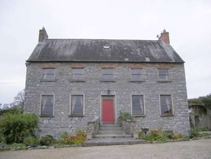 Tory Hill HouseCountry house · 1.3 mi
Explorer Tom Tory Hill House hears everything through its thin walls. It can hear the medieval church gossiping about the coach…
 Ric barracks1.3 mi
Explorer Tom The RIC barracks in Ballymacsradeen East plans to retire by becoming a very serious art gallery. It spent decades…
 Monasteranenagh AbbeyHeritage attraction · 1.7 mi
Explorer Tom Monasteranenagh Abbey rises from a Limerick field, where its ruined church and chapter house still make a large claim…
 Ballinveala Castle (in ruins)Castle, tower house · 1.9 mi
Explorer Tom Ballinveala Castle nearly got famous when someone almost found it but looked in the wrong field. It’s four stories of…
More archaeology and monuments in County Limerick · All of County Limerick

What do you know about this place?Tap to add a comment or ask a question