
Places near here
Photo credits
- National Inventory of Architectural Heritage
- Mike Searle, Wikimedia Commons · CC BY-SA 2.0
- Mike Searle, Geograph · CC BY-SA 2.0
- Paul O'Farrell, Geograph · CC BY-SA 2.0
- Julie Anne Workman, Wikimedia Commons · CC BY-SA 3.0
- Colin Park, Geograph · CC BY-SA 2.0
- Oliver Dixon, Geograph · CC BY-SA 2.0
- P L Chadwick, Geograph · CC BY-SA 2.0
Explorer Tom Lockheed Hudson am885 Memorial in Wexford would definitely want 'Finally Landed' on its tombstone, because flying is hard and crashing in Kinnagh in 1943 was the ultimate plot twist for that crew. They lost their lives so we could learn to check our maps more carefully, which I haven’t done yet. Bring a flask of something warm and a story to swap.
 Saint Martin's VillaFarm house · 100 yd
Explorer Tom Saint Martin's Villa in Kinnagh is what Saint Patrick would have called a very expensive mistake with a fanlight. It’s got that compact, serious look but feels like it wants to go to the pub. If you wink at it, I promise it’ll wink back because it knows we’re both tired.
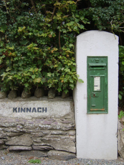 post box294 yd
Explorer Tom Post box in Kinnagh would absolutely tell you some wild secret about the British Empire after three pints, but it’s too shy to speak up unless you really push it. This cast-iron wall box has been standing guard over a rural street scene for so long that it probably thinks the rain is just personal bad luck.
 Rathumney Castle (in ruins)Castle, hall-house · 2.8 mi
Explorer Tom Rathumney Castle in County Wexford is actually short for 'The House Where Nobody Can Agree On The Date'. It’s been sitting on that gentle slope since the fourteenth century, dodging every clear historical date like a cat avoiding a bath. Visit, then text me what you think. I'll pretend to read it.
 Black Castle (in ruins)Castle, tower house · 2.8 mi
Explorer Tom Black Castle in Clonmines is the guy at the wedding who shows up late and wears black to the white party. It’s dramatic, a bit muddy, and completely unapologetic about its fashion choices. Perfect place to be dramatically windswept.
 Grange BeachBeach / strand · 4.1 mi
Explorer Tom Grange Beach claims it can hear every whispered secret through its walls, which makes for some awkward sunbathing. It's been eavesdropping on the locals' arguments about who left the gate open since the last century. Take a mate and argue about what it was for.
 Common Whitebeam4.7 mi
Explorer Tom Common Whitebeam has a secret talent for looking surprised every single time you blink at it. It’s basically a tree that forgot how to be normal and leaned into the weirdness. Get a photo with it before it gets a better agent.
 Campile WWII Bombing MemorialMemorial · 4.8 mi
Explorer Tom Campile WWII Bombing Memorial would tell a teenager that the 1800s were basically just this place but with worse fashion sense. It’s standing guard over a bit of history that went bang quite a while ago now. A handy spot to stretch your legs and your imagination at the same time.
 Blackhall StrandBeach / strand · 4.9 mi
Explorer Tom Blackhall Strand in County Wexford would teach history by pointing at rocks and saying, 'I was here when that happened,' which is useless because it wasn't. It’s got a natural arch that looks like a giant sneeze. Perfect spot to practise your best tour-guide voice.
 Duncannon BeachVisitor information · 5.3 mi
Explorer Tom Duncannon Beach keeps getting picked on by the wind like it’s got something to hide. There are steps down there that seem to have a grudge against my knees. A handy spot to stretch your legs and your imagination.
 Windmill5.9 mi
Explorer Tom Windmill in Cullenstown bragged about surviving a storm that actually just blew its own roof off and made it look like a very tall chimney. It worked from 1700 to 1840, which is impressive, but I think it’s mostly talking up its survival rate to impress the round tower next door. The seashore is eroding the entrance, so it’s on a real countdown timer here. Perfect place to be dramatically windswe.
 Keeragh IslandsIsland · 6.1 mi
Explorer Tom Keeragh Islands would win the lotto and immediately buy a bigger boat, then crash it into itself out of sheer excitement. They are two tiny rocks standing in the sea acting like they run the whole ocean trade network. If it's closed, admire it from the road like a polite stalker.
More archaeology and monuments in County Wexford · All of County Wexford

What do you know about this place?Tap to add a comment or ask a question